New Mexico State Road 3
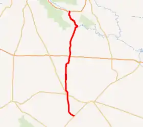
New Mexico State Road 3 (NM 3) is a north-south state highway in the state of New Mexico. NM 3's southern terminus is at U.S. Route 54 (US 54) in the small town of Duran, and the northern terminus is at Frontage Road 2116 (FR 2116) north of Ribera.
| ||||
|---|---|---|---|---|
NM 3 highlighted in red | ||||
| Route information | ||||
| Maintained by NMDOT | ||||
| Length | 72.401 mi[1] (116.518 km) | |||
| Major junctions | ||||
| South end | ||||
| North end | FR 2116 north of Ribera | |||
| Location | ||||
| Counties | Torrance, San Miguel | |||
| Highway system | ||||
| ||||

Route description
NM 3 begins at its intersection with US 54 in the unincorporated community of Duran. The road travels first in a northwest and then a primarily northern direction for about 14.5 miles (23.3 km) until its junction with US 285 and US 60 in Encino. The road then continues north for 25.5 miles (41.0 km) through largely uninhabited areas to its junction with Interstate 40 (I-40). It then continues in a generally northern direction past exit 323 on I-25 to its northern terminus at FR 2127 north of Ribera. This segment passes through Villanueva State Park, where the road briefly follows the Pecos River.
Major intersections
| County | Location | mi[2] | km | Destinations | Notes |
|---|---|---|---|---|---|
| Torrance | Duran | 0.000 | 0.000 | Southern terminus | |
| Encino | 14.476 | 23.297 | |||
| | 39.898– 40.004 | 64.210– 64.380 | I-40 exit 230 | ||
| San Miguel | | 66.645 | 107.255 | Northern terminus of NM 484 | |
| | 72.040 | 115.937 | I-25 exit 323 | ||
| | 72.401 | 116.518 | FR 2116 | Northern terminus | |
| 1.000 mi = 1.609 km; 1.000 km = 0.621 mi | |||||
See also
 U.S. Roads portal
References
- "Posted Route–Legal Description" (PDF). New Mexico Department of Transportation. March 16, 2010. p. 2. Retrieved December 22, 2013.
- "TIMS Road Segments by Posted Route/Point with AADT Info; NM, NMX-Routes" (PDF). New Mexico Department of Transportation. April 3, 2013. p. 2. Retrieved December 22, 2013.
External links
![]() Geographic data related to New Mexico State Road 3 at OpenStreetMap
Geographic data related to New Mexico State Road 3 at OpenStreetMap