U.S. Route 66 in New Mexico
The historic U.S. Route 66 (US 66, Route 66) ran east–west across the central part of the state of New Mexico, along the path now taken by Interstate 40 (I-40). However, until 1937, it took a longer route via Los Lunas, Albuquerque, and Santa Fe, now roughly New Mexico State Road 6 (NM 6), I-25, and US 84. Large portions of the old road parallel to I-40 have been designated NM 117, NM 118, NM 122, NM 124, NM 333, three separate loops of I-40 Business, and state-maintained frontage roads.
| |||||||||||||
|---|---|---|---|---|---|---|---|---|---|---|---|---|---|
| Will Rogers Highway | |||||||||||||
| Route information | |||||||||||||
| Maintained by NMDOT | |||||||||||||
| Existed | November 11, 1926–June 26, 1985[1] | ||||||||||||
| Major junctions | |||||||||||||
| West end | |||||||||||||
| |||||||||||||
| East end | |||||||||||||
| Highway system | |||||||||||||
| |||||||||||||
.svg.png.webp)
It is one of the roads on the Trails of the Ancients Byway, one of the designated New Mexico Scenic Byways.[2]
History
.svg.png.webp)

Route 66 in New Mexico was marked over portions of two auto trails — the National Old Trails Road from Arizona via Albuquerque and Santa Fe to just shy of Las Vegas, and one of the main routes of the Ozark Trails network from that point into Texas.[3] The state had taken over maintenance of these roads under several numbers: NM 6 from Arizona to Los Lunas, part of NM 1 through Albuquerque and Santa Fe to near Las Vegas, NM 56 to Santa Rosa, the short NM 104 to Cuervo, and part of NM 3 to Texas. While NM 56 and NM 104 were completely absorbed by US 66, NM 6 was reassigned to a route splitting from US 66 (old NM 6) at Laguna and heading straight east through Albuquerque, Moriarty, and Palma to US 66 at Santa Rosa. Except between Albuquerque and Moriarty, where it formed part of US 470, this was an unimproved road.[4][5][6]
New Mexico had long been controlled politically by the Santa Fe Ring, a group of businesspeople and officials with close ties to the Republican Party. In 1924, Democrat Arthur Thomas Hannett was unexpectedly elected for a single term (1925–1927) as governor. Blaming the Republican establishment in Santa Fe for his defeat, Hannett used the lame duck remainder of his term to force through a sixty-nine mile cutoff from Santa Rosa directly to Albuquerque, bypassing Santa Fe entirely. The hastily constructed new road opened January 3, 1927, while incoming governor Richard Dillon was still trying to get construction stopped.[7] Dillon was replaced by Arthur Seligman, a Democrat, in 1931.
This new NM 6 was approved as a future realignment of Route 66 by 1932, and in 1933, a new bridge over the Rio Puerco opened. Once paving was completed in 1937, with AASHO approval given on September 26, 1937,[8] Route 66 was moved to this shorter route, known as the Laguna Cut-off west of Albuquerque and the Santa Rosa Cut-off east of Albuquerque.[9] The bypassed roads became NM 6 once again to the west and part of US 84 to the east.
Route description
From the Arizona state line to the Grants area the landscape is mountainous, and US 66 meanders around I-40. It also passes through some Indian reservations. At Laguna, New Mexico is the Laguna Indian Pueblo.[10]
At Mesita, the highway originally followed what is now NM 6 to east of I-25 at Los Lunas. It passed through Albuquerque from south to north along Fourth Street, part of the historic El Camino Real de Tierra Adentro (El Camino Real). The highway is now replaced with I-25 through Santa Fe to, almost, Las Vegas (Historic 66 turns south before reaching Las Vegas), though several old sections exist which are barely (if at all) driveable. From south of Las Vegas back to I-40, the road has been replaced with US 84.[11]
The later, and more popular, alignment, continued straight west to Albuquerque, becoming Central Avenue through the city. While the former US 66 through Albuquerque is now owned and maintained by the city of Albuquerque, a few US-66/BUSINESS I-40 signs remain along Central Avenue in the downtown area. East of Albuquerque, US 66 is now NM 333 all the way to Moriarty. A stretch of NM 333 in Tijeras is a musical road, with rumble strips that play "America the Beautiful". I-40 east of Moriarty to Santa Rosa was built by adding a second set of lanes to US 66. East of Santa Rosa, US 66 is now largely frontage roads for I-40 or business loops for Santa Rosa and Tucumcari. At San Jon, the original alignment (now gravel) continues to the Texas state line at the historic ghost town of Glenrio. A later alignment is the north frontage road for I-40.[12]
Major intersections
This table represents US 66's junctions in 1950.
| County | Location | mi[13] | km | Destinations | Notes | |||
|---|---|---|---|---|---|---|---|---|
| McKinley | | 0 | 0.0 | Continuation into Arizona | ||||
| Gallup | 21 | 34 | Eastern end of US 666 overlap; now southbound NM 610 (locally) and US 491 (long-distance) | |||||
| Now northbound NM 610 (locally) and NM 602 (long-distance) | ||||||||
| Thoreau | 52 | 84 | Western end of NM 56 overlap; now NM 371 | |||||
| Cibola | Bluewater Village | 69 | 111 | Now NM 606 | ||||
| Milan | 77 | 124 | Western end of NM 53 overlap; now NM 605 | |||||
| Grants | 79 | 127 | Eastern end of NM 53 overlap | |||||
| Paraje | 104 | 167 | Now Casa Blanca Road | |||||
| Correo | 123 | 198 | US 66 prior to 1937 | |||||
| Bernalillo | Albuquerque | 152 | 245 | |||||
| 155 | 249 | Pre-1937 US 66; later NM 313 | ||||||
| Tijeras | 171 | 275 | Now NM 337 | |||||
| Santa Fe |
No major junctions | |||||||
| Torrance | Moriarty | 194 | 312 | Former US 366 east | ||||
| Clines Corners | 216 | 348 | ||||||
| | 229 | 369 | ||||||
| Guadalupe | | 255 | 410 | Western end of US 84 overlap | ||||
| Santa Rosa | 273 | 439 | Western end of US 54 overlap | |||||
| 275 | 443 | Eastern end of US 84 overlap | ||||||
| | 284 | 457 | ||||||
| Newkirk | 300 | 480 | ||||||
| Quay | Tucumcari | 333 | 536 | Eastern end of US 54 overlap | ||||
| Now NM 104/NM 209 | ||||||||
| | 339 | 546 | Now NM 278 | |||||
| San Jon | 356 | 573 | Now NM 469 | |||||
| Endee | 369 | 594 | ||||||
| Glenrio | 374 | 602 | Continuation into Texas | |||||
| 1.000 mi = 1.609 km; 1.000 km = 0.621 mi | ||||||||
Structures

The New Mexico Madonna of the Trail is one of a dozen monuments (one in each state on the National Old Trails Road) commemorating the hardships of early pioneer travellers. She stands on US 66 in Albuquerque.[14] Albuquerque is also home to the 1927 Art Deco themed KiMo Theater[15] and the first modern suburban shopping mall in New Mexico, Nob Hill.[16]
Historic districts
Fort Wingate, an abandoned military installation east of Gallup, traces its history to attempts in the 19th century to forcibly displace Navajo to native reservations. It later served as a line of defence against the Apache. Closed in 1912, it reopened briefly to house prisoners during both world wars.[17]
The Barelas-South Fourth Street Historic District is a collection of commercial buildings from various eras in a formerly Hispanic residential neighbourhood in Albuquerque. Eras represented include the arrival of the Atchison, Topeka and Santa Fe Railway and the later construction of US 66.[18]
The Park Lake Historic District is a 25-acre municipal park on a lake in Santa Rosa. Constructed under the Works Progress Administration between 1934 and 1940, the park was a make-work project during the Great Depression.[19]
Restaurants
The historic Jones Motor Company building in Albuquerque, originally a motorcar dealership,[20] has been re-purposed to house the local Kelly's Brew Pub.
Service and filling stations
Richardson's Store in Montoya, a 1901 railroad town, initially provided provisions for Rock Island Railroad workers and ranchers.[21] When Route 66 came to town, the store carried groceries and auto supplies. It closed after I-40 bypassed the community.
Roy T. Herman's Garage and Service Station in Thoreau was moved in 1937 from Grants, where it had originally been established in 1935. The routing of Route 66 had moved, so the station moved with it to keep its Route 66 clientele.[22]
Trading posts
New Mexico is home to the Native American Pueblo of Santo Domingo (Kewa Pueblo) in Santo Domingo [23] and the Pueblo of Laguna in Laguna.[24] Roadside merchants on Route 66 often based their stores on the design of the early trading posts which originally served the native community.
Bowlin's Old Crater Trading Post, Bluewater has long been closed and vacant. Originally a native trading post, its proprietors established a modern chain of highway service centres.[25] Albuquerque's 1939 Maisel's Indian Trading Post, which once employed hundreds of native craftspeople, was reopened in the 1980s and remains in operation today.[26]
Camps, motor courts, and motels
Various towns and cities quickly established roadside motel strips to accommodate a burgeoning traffic from Route 66 travellers.
Tucumcari had long advertised "2000 motel rooms" (later "1200 motel rooms") on roadside signage for hundreds of miles along US 66 using the slogan "Tucumcari tonite!" At least one historically restored Tucumcari Boulevard motel, the 12-room, neon-lit, 1939 Blue Swallow Motel, is listed on the National Register of Historic Places.[27] Another motel recently restored nearby is the Motel Safari. The Motel Safari was built in 1959 by Chester Dohrer and features a mid-century modern retro design with "Doo Wop" or "Googie" styled architecture. Boomerangs, holes in cinder blocks, counter stacked bricks protruding from the façade and whimsical metal cylinders that light up at night, along with its famous camel atop the neon sign, paying tribute to the U.S. Camel Corps that once came through the area in the 1800s on a surveying expedition for a future national road system.
Central Avenue in Albuquerque has many motels from this era, although some (such as the Aztec Motel) have been demolished. Historic Albuquerque lodgings from Route 66's heyday include the Luna Lodge,[28] Tewa Motor Lodge,[29] De Anza Motor Lodge[30] and El Vado Auto Court.[31] Some of these motels are currently closed but are the target of local efforts to ensure their historic preservation.
The El Rancho Hotel in Gallup has been the temporary home of many movie stars.[32]
Bridges and road segments
The Rio Puerco Bridge, a Parker Through truss bridge crossing the Rio Puerco, was built in 1933.[33] Eleven New Mexico road segments on US 66 are listed on the National Register of Historic Places; some originally incorporated wooden bridges to carry the road through flood plains. Listed road segments include: Glenrio to San Jon; San Jon to Tucumcari; Palomas to Montoya; Montoya to Cuervo; Cuervo to NM 156; Albuquerque to Rio Puerco; Laguna to McCartys; McCartys to Grants; Milan to Continental Divide; Iyanbito to Rehobeth; and Manuelito to the Arizona border.[34]
Related routes
These routes were designated along former alignments of US 66 throughout the state.
State Road 118
| |
|---|---|
| Location | Arizona state line to near Fort Wingate |
| Length | 36.852 mi[35] (59.308 km) |
State Road 118 (NM 118) is a 36.852-mile-long (59.308 km) state highway in the US state of New Mexico. NM 118's western terminus is at the Arizona–New Mexico border where it continues westward as Grant Road, and the eastern terminus is at Interstate 40 (I-40) northeast of Fort Wingate. NM 118 follows the routing of the former Historic U.S. Route 66.
The entire route is in McKinley County.
| Location | mi[36] | km | Destinations | Notes | |
|---|---|---|---|---|---|
| | 0.000 | 0.000 | Grant Road | Continues west at Arizona border as Grant Road | |
| | 8.100– 8.500 | 13.036– 13.679 | I-40 exit 8 | ||
| Gallup | 16.579 | 26.681 | I-40 exit 16 | ||
| 20.809 | 33.489 | Access to NM 602 via Arnold Street and Aztec Avenue east | |||
| 21.792 | 35.071 | ||||
| 22.710 | 36.548 | Eastern terminus of NM 609 | |||
| 23.740 | 38.206 | Eastern terminus of NM 564 | |||
| Rehoboth | 25.841 | 41.587 | I-40 exit 26 | ||
| Church Rock | 29.517 | 47.503 | Southern terminus of NM 566 | ||
| Wingate | 33.446 | 53.826 | Northern terminus of NM 400, to eastbound I-40 exit 33 | ||
| | 36.649– 36.852 | 58.981– 59.308 | Eastern terminus, I-40 exit 36 | ||
| 1.000 mi = 1.609 km; 1.000 km = 0.621 mi | |||||
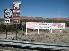
State Road 122
| |
|---|---|
| Location | Near Thoreau to near Grants |
| Length | 38.740 mi[37] (62.346 km) |
State Road 122 (NM 122) is a 38.740-mile-long (62.346 km) state highway in the US state of New Mexico. NM 122's western terminus is at Interstate 40 (I-40) west of Thoreau, and the eastern terminus is at I-40 in Grants. NM 122 follows the routing of the former Historic U.S. Route 66. At the September 20, 2018 Transportation Commission meeting the bridge carrying NM 122 over I-40 was dedicated as "Sgt. Jackson Gibson Memorial Bridge" to honor Jackson Gibson for his service as a veteran, community leader and state transportation commissioner.[38]
| County | Location | mi[39] | km | Destinations | Notes |
|---|---|---|---|---|---|
| McKinley | Continental Divide | 0.000 | 0.000 | Western terminus; I-40 exit 47 | |
| Thoreau | 6.134 | 9.872 | |||
| Prewitt | 16.090 | 25.894 | Northern terminus of NM 412; to I-40 exit 63 | ||
| Cibola | | 24.989 | 40.216 | Northern terminus of NM 606; to I-40 exit 72 | |
| | 26.959 | 43.386 | Former NM 334 | ||
| | 29.799 | 47.957 | Northern terminus of NM 568 | ||
| Milan | 32.022 | 51.534 | Southern terminus of NM 605 | ||
| 32.211 | 51.839 | Eastern terminus of NM 615; to I-40 exit 79 | |||
| Grants | 34.652 | 55.767 | Eastern terminus of NM 53; to I-40 exit 81 | ||
| 36.003 | 57.941 | Southern terminus of NM 547 | |||
| 37.380 | 60.157 | Northern terminus of NM 117 | |||
| 38.455– 38.740 | 61.887– 62.346 | Eastern terminus; I-40 exit 85 | |||
| 1.000 mi = 1.609 km; 1.000 km = 0.621 mi | |||||
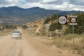
State Road 124
| |
|---|---|
| Location | Near Grants to near Laguna |
| Length | 25.253 mi[37] (40.641 km) |
State Road 124 (NM 124) is a 25.523-mile-long (41.075 km) state highway in the US state of New Mexico. NM 124's western terminus is at NM 117 southeast of Grants, and the eastern terminus is at Interstate 40 (I-40) east of Laguna. NM 124 follows the routing of the former Historic U.S. Route 66.
The entire route is in Cibola County.
| Location | mi[40] | km | Destinations | Notes | |
|---|---|---|---|---|---|
| | 0.000 | 0.000 | Western terminus | ||
| | 7.394 | 11.899 | I-40 exit 96 | ||
| Laguna | 23.750 | 38.222 | Southern terminus of NM 279 | ||
| | 25.543 | 41.107 | Eastern terminus, I-40 exit 114 | ||
| 1.000 mi = 1.609 km; 1.000 km = 0.621 mi | |||||
State Road 333
| |
|---|---|
| Location | Albuquerque to Moriarty |
| Length | 27.715 mi[41] (44.603 km) |
NM 333 begins in eastern Albuquerque at an intersection of Tramway Boulevard (NM 556) and Central Avenue, proceeding east on Central, the route of the former U.S. Route 66 (US 66). After a partial interchange with Interstate 40 (I-40), the highway enters the Sandia Mountains through Tijeras Canyon, where it crosses to the north side of I-40 in a diamond interchange. After traveling through Carnuel, it crosses back to the south side of I-40, though this crossing has no interchange.
Before entering the town of Tijeras, there is a "musical road" feature where rumble strips are arranged to play America the Beautiful for eastbound travelers.[42] Once in Tijeras itself, the highway intersects NM 337, which travels to the southeast, and NM 14, which heads northeast to Santa Fe. Continuing east, NM 333 travels through Sedillo, where it intersects the former NM 306 and NM 217. The highway then leaves Bernalillo County, and enters Santa Fe County and the town of Edgewood, where it intersects NM 344. Shortly thereafter, the highway enters Torrance County and the city of Moriarty, where it ends at an intersection with I-40 Business (I-40 Bus.).[43]
NM 333 follows the routing of the former Historic U.S. Route 66.
| County | Location | mi[44] | km | Destinations | Notes |
|---|---|---|---|---|---|
| Bernalillo | Albuquerque | 0.000 | 0.000 | Western terminus; I-40 exit 167 | |
| Carnuel | 2.060 | 3.315 | I-40 exit 170 | ||
| Tijeras | 6.810 | 10.960 | To I-40 exit 175 westbound on/ off ramps via NM 337 north | ||
| | 7.404 | 11.916 | Southern terminus of NM 14; to I-40 exit 175 westbound on/ off ramps only | ||
| | 7.564 | 12.173 | I-40 exit 175 eastbound on ramp only | ||
| | 10.164 | 16.357 | Access Road (FR 4058) | To I-40 exit 178 | |
| | 13.764 | 22.151 | I-40 exit 181 eastbound on/ off ramps only | ||
| | 13.950 | 22.450 | Sedillo Road | Southern terminus of former NM 306; to I-40 exit 181 westbound on/ off ramps only | |
| | 15.342 | 24.691 | Northern terminus of NM 217 | ||
| Santa Fe | Edgewood | 19.737 | 31.764 | Southern terminus of NM 344; to I-40 exit 187 | |
| Torrance | Moriarty | 27.715 | 44.603 | Eastern terminus | |
| 1.000 mi = 1.609 km; 1.000 km = 0.621 mi | |||||
References
- Special Committee on U.S. Route Numbering (June 26, 1985). "Route Numbering Committee Agenda" (Report). Washington, DC: American Association of State Highway and Transportation Officials. p. 5 – via Wikisource.
- "Trail of the Ancients". New Mexico Tourism Department. Archived from the original on August 21, 2014. Retrieved August 14, 2014.
- "Map of the Ozark Trails". Drivetheost.com. Retrieved August 26, 2012.
- Rand McNally and Company (1926). "Arizona and New Mexico" (Map). Rand McNally Auto Road Atlas. Scale not given. Chicago: Rand McNally and Company. p. 69 – via Broer Map Library.
- Clason Map Company (1926). "New Mexico" (Map). Touring Atlas of the United States. Clason Map Company.
- Rand McNally and Company (1927). "Arizona and New Mexico" (Map). Junior Auto Road Map. Scale not given. Chicago: Rand McNally and Company.
- Antonson, Rick (2012). Route 66 Still Kicks: Driving America's Main Street. Toronto: Dundurn Press. p. 195 – via Google Books.
- Powell, James R. "A Brief History of U.S. Highway 66 and the Route 66 Association of Missouri". Route 66 Association of Missouri.
- Kammer, David (March 2003). "Route 66 Through New Mexico: Re-Survey Report". National Park Service.
- "New Mexico Route 66". theroadwanderer.net. Retrieved November 12, 2014.
- "Historic Route 66 - New Mexico". historic66.com. Retrieved November 24, 2014.
- "Route 66". americansouthwest.net. Retrieved November 24, 2014.
- Official Road Map of New Mexico (PDF) (Map). Santa Fe: New Mexico State Highway Department. 1950. Archived from the original (PDF) on January 16, 2017. Retrieved October 31, 2020.
- National Park Service (September 27, 1998). "Madonna of the Trail". National Park Service. Retrieved August 26, 2012.
- National Park Service (n.d.). "KiMo Theatre". National Park Service. Retrieved August 26, 2012.
- National Park Service (n.d.). "Nob Hill Shopping Center". National Park Service. Retrieved August 26, 2012.
- National Park Service (n.d.). "Fort Wingate Historic District". National Park Service. Retrieved August 26, 2012.
- National Park Service (n.d.). "Barelas South 4th Street Historic District". National Park Service. Retrieved August 26, 2012.
- National Park Service (n.d.). "Park Lake Historic District". National Park Service. Retrieved August 26, 2012.
- National Park Service (n.d.). "Jones Motor Company". National Park Service. Retrieved August 26, 2012.
- National Park Service (n.d.). "Richardson Store". National Park Service. Retrieved August 26, 2012.
- National Park Service (n.d.). "Roy Herman's Service Station". National Park Service. Retrieved August 26, 2012.
- National Park Service (n.d.). "Pueblo of Santo Domingo". National Park Service. Retrieved August 26, 2012.
- National Park Service (n.d.). "Pueblo of Laguna". National Park Service. Retrieved August 26, 2012.
- National Park Service (n.d.). "Bowlin's Old Crater Trading Post". National Park Service. Retrieved August 26, 2012.
- National Park Service (n.d.). "Maisel's Indian Trading Post". National Park Service. Retrieved August 26, 2012.
- National Park Service (n.d.). "Blue Swallow Motel". National Park Service. Retrieved August 26, 2012.
- National Park Service (n.d.). "Luna Lodge". National Park Service. Retrieved August 26, 2012.
- National Park Service (n.d.). "Tewa Motor Lodge". National Park Service. Retrieved August 26, 2012.
- National Park Service (n.d.). "De Anza Motor Lodge". National Park Service. Retrieved August 26, 2012.
- National Park Service (n.d.). "El Vado Auto Court Motel". National Park Service. Retrieved August 26, 2012.
- National Park Service (n.d.). "El Rancho Hotel". National Park Service. Retrieved August 26, 2012.
- National Park Service (n.d.). "Rio Puerco Bridge". National Park Service. Retrieved August 26, 2012.
- National Park Service (n.d.). "New Mexico Road Segments". National Park Service. Retrieved August 26, 2012.
- "Posted Route: Legal Description" (PDF). New Mexico Department of Transportation. March 16, 2010. p. 29. Retrieved October 25, 2018.
- "TIMS Road Segments by Posted Route/Point with AADT Info; NM, NMX-Routes" (PDF). New Mexico Department of Transportation. April 3, 2013. pp. 37–38. Retrieved October 20, 2018.
- Posted Routes (2010), p. 30
- New Mexico State Transportation Commission Meeting (PDF) (Report). Milan: New Mexico Department of Transportation. September 20, 2018. pp. 61–62. Retrieved February 19, 2019.
- TIMS (2013), pp. 38–39
- TIMS (2013), pp. 39–40
- Posted Routes (2010), p. 71
- "Route 66 ‘singing road’ debuts in New Mexico", KRQE News 13 (TV), October 1, 2014.
- Google (January 27, 2019). "Overview map of NM 333" (Map). Google Maps. Google. Retrieved January 27, 2019.
- TIMS (2013), pp. 63–64
External links
| Wikimedia Commons has media related to U.S. Route 66 in New Mexico. |
- Route 66 through New Mexico MPS–documentation of historic districts and individual properties along Route 66 on the National Register of Historic Places
| Previous state: Arizona |
New Mexico | Next state: Texas |