New Mexico State Road 6
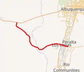
New Mexico State Road 6 (NM 6) is an east–west state highway in the state of New Mexico. NM 6's western terminus is at Interstate 40 (I-40) west of Albuquerque, and the eastern terminus is at NM 47 in Los Lunas.
| ||||
|---|---|---|---|---|
NM 6 highlighted in red | ||||
| Route information | ||||
| Maintained by NMDOT | ||||
| Length | 36.360 mi[1] (58.516 km) | |||
| Major junctions | ||||
| West end | ||||
| ||||
| East end | ||||
| Location | ||||
| Counties | Cibola, Valencia | |||
| Highway system | ||||
| ||||


Route description
NM 6 begins at an intersection with Interstate 40 (I-40) about 30 miles (48 km) west of Albuquerque. The road travels to the southeast and then to the east. It has an interchange with I-25 in Los Lunas. The road passes through the village of Los Lunas as Main Street, crossing the Rio Grande before its eastern terminus at NM 47. Some maps show NM 6 continuing south concurrently with NM 47 through Belen and onward to U.S. Route 60 (US 60). This alignment is not reflected in the state highway log.
History
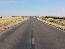
Much of NM 6 follows the historic alignment of US 66 and is signed as such.
Major intersections
| County | Location | mi[2] | km | Destinations | Notes |
|---|---|---|---|---|---|
| Cibola | Laguna Indian Reservation | 0.000 | 0.000 | Western terminus at I-40 Exit 126 | |
| Valencia | Los Lunas | 32.621 | 52.498 | I-25 Exit 203 | |
| 34.364 | 55.303 | ||||
| Valencia | 35.890 | 57.759 | Northern terminus of NM 263 | ||
| 36.360 | 58.516 | Eastern terminus | |||
| 1.000 mi = 1.609 km; 1.000 km = 0.621 mi | |||||
See also
 U.S. Roads portal
References
- "Posted Route–Legal Description" (PDF). New Mexico Department of Transportation. March 16, 2010. p. 3. Retrieved December 19, 2013.
- "TIMS Road Segments by Posted Route/Point with AADT Info; NM, NMX-Routes" (PDF). New Mexico Department of Transportation. April 3, 2013. pp. 3–4. Retrieved December 19, 2013.
External links
![]() Geographic data related to New Mexico State Road 6 at OpenStreetMap
Geographic data related to New Mexico State Road 6 at OpenStreetMap