Newell, Iowa
Newell is a city in Buena Vista County, Iowa, United States. The population was 876 according to the 2010 census.
Newell, Iowa | |
|---|---|
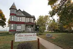 Allee Mansion is listed on the National Register of Historic Places | |
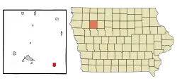 Location of Newell, Iowa | |
| Coordinates: 42°36′22″N 95°0′8″W | |
| Country | |
| State | |
| County | Buena Vista |
| Government | |
| • Mayor | Justin Melohn |
| Area | |
| • Total | 1.26 sq mi (3.27 km2) |
| • Land | 1.26 sq mi (3.27 km2) |
| • Water | 0.00 sq mi (0.00 km2) |
| Elevation | 1,263 ft (385 m) |
| Population | |
| • Total | 876 |
| • Estimate (2019)[3] | 852 |
| • Density | 674.58/sq mi (260.49/km2) |
| Time zone | UTC-6 (Central (CST)) |
| • Summer (DST) | UTC-5 (CDT) |
| ZIP code | 50568 |
| Area code(s) | 712 |
| FIPS code | 19-55965 |
| GNIS feature ID | 0459505 |
| Website | www |
History
Newell was established in 1870 as a station for the Dubuque and Sioux City Railroad, and was named after an official with the Illinois Central Railroad. Newell was incorporated in 1876.[4]
Geography
According to the United States Census Bureau, the city has a total area of 1.27 square miles (3.29 km2), all land.[5]
Demographics
| Year | Pop. | ±% |
|---|---|---|
| 1880 | 348 | — |
| 1890 | 540 | +55.2% |
| 1900 | 762 | +41.1% |
| 1910 | 728 | −4.5% |
| 1920 | 809 | +11.1% |
| 1930 | 812 | +0.4% |
| 1940 | 854 | +5.2% |
| 1950 | 884 | +3.5% |
| 1960 | 893 | +1.0% |
| 1970 | 877 | −1.8% |
| 1980 | 913 | +4.1% |
| 1990 | 1,089 | +19.3% |
| 2000 | 887 | −18.5% |
| 2010 | 876 | −1.2% |
| 2019 | 852 | −2.7% |
| Source:"U.S. Census website". United States Census Bureau. Retrieved 2020-03-29. and Iowa Data Center Source: | ||
2010 census
As of the census[2] of 2010, there were 876 people, 356 households, and 225 families living in the city. The population density was 689.8 inhabitants per square mile (266.3/km2). There were 377 housing units at an average density of 296.9 per square mile (114.6/km2). The racial makeup of the city was 95.5% White, 0.3% African American, 0.1% Native American, 0.3% Asian, 2.6% from other races, and 1.0% from two or more races. Hispanic or Latino of any race were 4.2% of the population.
There were 356 households, of which 30.1% had children under the age of 18 living with them, 51.7% were married couples living together, 9.6% had a female householder with no husband present, 2.0% had a male householder with no wife present, and 36.8% were non-families. 34.0% of all households were made up of individuals, and 15.5% had someone living alone who was 65 years of age or older. The average household size was 2.34 and the average family size was 3.01.
The median age in the city was 41.1 years. 25.8% of residents were under the age of 18; 6.5% were between the ages of 18 and 24; 22.2% were from 25 to 44; 25% were from 45 to 64; and 20.5% were 65 years of age or older. The gender makeup of the city was 48.2% male and 51.8% female.
2000 census
As of the census[7] of 2000, there were 887 people, 361 households, and 237 families living in the city. The population density was 706.9 people per square mile (274.0/km2). There were 381 housing units at an average density of 303.6 per square mile (117.7/km2). The racial makeup of the city was 97.29% White, 0.11% African American, 0.23% Native American, 0.11% Asian, 1.92% from other races, and 0.34% from two or more races. Hispanic or Latino of any race were 3.16% of the population.
There were 361 households, out of which 30.5% had children under the age of 18 living with them, 54.3% were married couples living together, 8.3% had a female householder with no husband present, and 34.1% were non-families. 30.7% of all households were made up of individuals, and 15.5% had someone living alone who was 65 years of age or older. The average household size was 2.32 and the average family size was 2.91.
24.6% were under the age of 18, 4.6% from 18 to 24, 25.1% from 25 to 44, 17.9% from 45 to 64, and 27.7% were 65 years of age or older. The median age was 42 years. For every 100 females, there were 91.2 males. For every 100 females age 18 and over, there were 86.9 males.
The median income for a household in the city was $31,204, and the median income for a family was $33,594. Males had a median income of $29,886 versus $19,286 for females. The per capita income for the city was $13,554. About 9.2% of families and 8.7% of the population were below the poverty line, including 10.6% of those under age 18 and 6.4% of those age 65 or over.
Education
Newell is served by the Newell-Fonda Community School District,[8] which operates Newell-Fonda High School in Newell.
Notable person
- George L. Dobson (1861-1919). Iowa Secretary of State, lived in Newell; he served as mayor of Newell.[9]
References
- "2019 U.S. Gazetteer Files". United States Census Bureau. Retrieved July 17, 2020.
- "U.S. Census website". United States Census Bureau. Retrieved 2012-05-11.
- "Population and Housing Unit Estimates". United States Census Bureau. May 24, 2020. Retrieved May 27, 2020.
- Savage, Tom (2007). A Dictionary of Iowa Place-Names. University of Iowa Press.
- "US Gazetteer files 2010". United States Census Bureau. Archived from the original on 2012-01-25. Retrieved 2012-05-11.
- "Census of Population and Housing". Census.gov. Retrieved June 4, 2015.
- "U.S. Census website". United States Census Bureau. Retrieved 2008-01-31.
- "Newell-Fonda." Iowa Department of Education. Retrieved on July 25, 2018.
- 'Death of Geo. L. Dobson Recalls History,' The Newell Mirror, February 27, 1919, pg. 1
External links
Municipalities and communities of Buena Vista County, Iowa, United States | ||
|---|---|---|
| Cities | Map of Iowa highlighting Buena Vista County | |
| Townships | ||
| Unincorporated communities | ||
| ||
