Newtown Creek (Neshaminy Creek tributary)
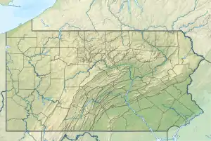
Newtown Creek is a tributary, rising near Stoop Road in Newtown Township, Bucks County, Pennsylvania, United States.[1] It is part of the Delaware River watershed[2] and is located entirely in Bucks County, Pennsylvania.[3] The Newtown Creek Bridge over Centre Avenue was added to the National Register of Historic Places in 1988.
| Newtown Creek | |
|---|---|
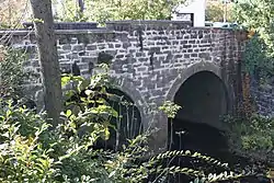 Newtown Creek Bridge | |
 Newtown Creek | |
| Location | |
| Country | United States |
| State | Pennsylvania |
| County | Bucks |
| Township | Newtown, Middletown |
| Borough | Newtown |
| Physical characteristics | |
| Source | |
| • coordinates | 40°15′56″N 74°57′51″W |
| • elevation | 320 feet (98 m) |
| Mouth | |
• coordinates | 40°12′39″N 74°56′34″W |
• elevation | 69 feet (21 m) |
| Length | 5.66 miles (9.11 km) |
| Basin size | 6.29 square miles (16.3 km2) |
| Basin features | |
| Progression | Newtown Creek → Neshaminy Creek → Delaware River → Delaware Bay |
| River system | Delaware River |
| Landmarks | All Saints Cemetery, Roberts Ridge Park, Newtown Cemetery, Newtown Creek Bridge, George School |
| Slope | 44.35 feet per mile (8.400 m/km) |
Statistics
Newtown Creek rises near Stoopville Road east of Pennsylvania Route 413,[1] flows generally in a southerly direction to its confluence at the Neshaminy Creek's 16.1 river mile[4] passing along the western side of Newtown Borough. Its watershed is approximately 6.29 square miles (16.3 km2).[5]
Tributaries
Newtown Creek has one unnamed tributary on the left bank near Wright's Road.
Geology
Newtown Creek rises in the Lockatong Formation, sedimentary rock deposited during the Upper Triassic. Mineralogy includes argillite, shale, some limestone and calcareous shale.
Municipalities
Crossings and Bridges
| Crossing | NBI Number | Length | Lanes | Spans | Material/Design | Built | Reconstructed | Latitude | Longitude |
|---|---|---|---|---|---|---|---|---|---|
| Pennsylvania Route 532 (Newtown Bypass) | 7003 | 9 metres (30 ft) | 2 | 1 | Steel culvert | 1974 | 40°13'6"N | 74°56'24"W | |
| Barclay Street | 7510 | 11 metres (36 ft) | 1 | 1 | Steel stringer/multi-beam or girder | 1917 | 2007 | 40°13'19.2"N | 74°56'17.8"W |
| West Centre Avenue | 7289 | 10 metres (33 ft) | 2 | 2 | Masonry arch-deck | 1796 | 1875 | 40°13'40.4"N | 74°56'18"W |
| West Washington Avenue | 17 metres (56 ft) | 2 | 1 | Steel girder or floorbeam system | 1903 | 1996 | 40°13'45.8"W | 74°56'16.3"W | |
| Jefferson Street | 7282 | 22 metres (72 ft) | 2 | 1 | Steel girder or floorbeam system | 1903 | 1996 | 40°14'0"N | 74°56'12"W |
| Pennsylvania Route 532 (Washington Crossing Road) | 7050 | 12 metres (39 ft) | 2 | 1 | Prestressed concrete box beam or girders | 1967 | 40°14'32.6"N | 74°56'2"W | |
| Wrights Road | 7517 | 12 metres (39 ft) | 2 | 1 | Prestressed concrete box beam or girders-multiple | 1983 | 40°15'18"N | 74°56'18"W | |
| Eagle Road | |||||||||
| South Drive | |||||||||
| North Drive | |||||||||
| Stoopville Road |
See also
References
- Google Maps, 2017, retrieved 7 May 2017
- Neshaminy Creek
- MacReynolds, George, Place Names in Bucks County, Pennsylvania, Doylestown, Bucks County Historical Society, Doylestown, PA, 1942, P278.
- paGazetteerOfStreams, lycomingedu, p105, I.D. 02561 (PDF)
- Geographic Names Information Systems (GNIS), I.D. 1182427
- http://www.nationalbridges.com/, retrieved 24 June 2017
