Nienstädt
Nienstädt is a municipality in the district of Schaumburg, in Lower Saxony, Germany. It is situated approximately 4 km southwest of Stadthagen, and 17 km east of Minden.
Nienstädt | |
|---|---|
Location of Nienstädt within Schaumburg district 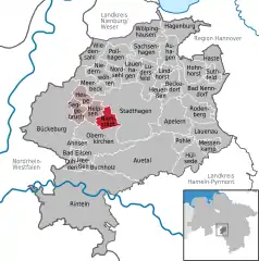 | |
 Nienstädt  Nienstädt | |
| Coordinates: 52°17′21″N 9°10′7″E | |
| Country | Germany |
| State | Lower Saxony |
| District | Schaumburg |
| Municipal assoc. | Nienstädt |
| Subdivisions | 4 |
| Government | |
| • Mayor | Gerhard Widdel (SPD) |
| Area | |
| • Total | 8.31 km2 (3.21 sq mi) |
| Elevation | 104 m (341 ft) |
| Population (2019-12-31)[1] | |
| • Total | 4,450 |
| • Density | 540/km2 (1,400/sq mi) |
| Time zone | UTC+01:00 (CET) |
| • Summer (DST) | UTC+02:00 (CEST) |
| Postal codes | 31688 |
| Dialling codes | 05721, 05724 |
| Vehicle registration | SHG |
Nienstädt is part of the Samtgemeinde ("collective municipality") Nienstädt.
Geography
Nienstädt lies on the northern slopes of the Bückeberge between Bückeburg and Stadthagen on the B 65 federal highway.
The four parishes in the municipality are Sülbeck, Liekwegen, Wackerfeld and Meinefeld. While Sülbeck and Nienstädt are bisected by the B 65, Liekwegen runs along the Bückeberg as a ribbon village. Wackerfeld and Meinefeld lie in open country north of Nienstädt.
Neighbouring communities (clockwise) are the towns of Stadthagen and Obernkirchen and the village of Helpsen.
References
This article is issued from Wikipedia. The text is licensed under Creative Commons - Attribution - Sharealike. Additional terms may apply for the media files.