Nippletop (Zion)
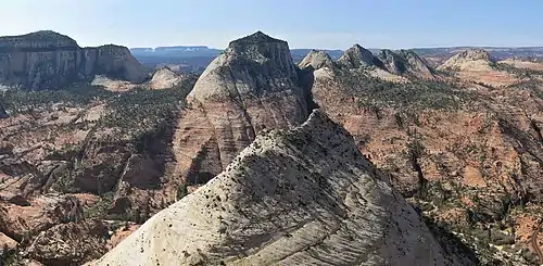
Nippletop is a 6,715-foot (2,050 meter) elevation white Navajo Sandstone summit located in Zion National Park, in Washington County of southwest Utah, United States. Nippletop is situated one mile immediately west of Crazy Quilt Mesa, and one mile south of the Zion – Mount Carmel Highway, towering 1,200 feet (365 meters) above it. Precipitation runoff from this unofficially named mountain drains into tributaries of the Virgin River.
| Nippletop | |
|---|---|
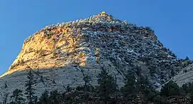 North-northeast aspect, from Zion – Mount Carmel Highway | |
| Highest point | |
| Elevation | 6,715 ft (2,047 m) [1] |
| Prominence | 795 ft (242 m) [2] |
| Parent peak | Crazy Quilt Mesa (6,760 ft)[1] |
| Isolation | 0.74 mi (1.19 km) [1] |
| Coordinates | 37°12′39″N 112°54′08″W [1] |
| Geography | |
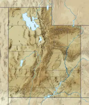 Nippletop Location in Utah  Nippletop Nippletop (the United States) | |
| Location | Zion National Park Washington County, Utah United States |
| Parent range | Colorado Plateau |
| Topo map | USGS Springdale East |
| Geology | |
| Age of rock | Jurassic |
| Type of rock | Navajo sandstone |
| Climbing | |
| Easiest route | class 2+ scrambling[1] |
Climate
Spring and fall are the most favorable seasons to visit Nippletop. According to the Köppen climate classification system, it is located in a Cold semi-arid climate zone, which is defined by the coldest month having an average mean temperature below 32 °F (0 °C), and at least 50% of the total annual precipitation being received during the spring and summer. This desert climate receives less than 10 inches (250 millimeters) of annual rainfall, and snowfall is generally light during the winter.[3]
See also
References
- ""Nippletop" - 6,715' UT". listsofjohn.com. Retrieved 2020-10-17.
- "Nippletop, Utah". Peakbagger.com.
- "Zion National Park, Utah, USA - Monthly weather forecast and Climate data". Weather Atlas. Archived from the original on August 31, 2020. Retrieved 31 August 2020.
External links
- Zion National Park National Park Service
- Weather forecast: National Weather Service