Norcatur, Kansas
Norcatur is a city in Decatur County, Kansas, United States. As of the 2010 census, the city population was 151.[8]
Norcatur, Kansas | |
|---|---|
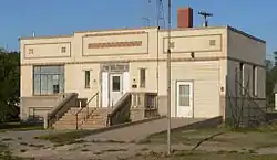 Norcatur's 1937 city hall is listed in the National Register of Historic Places[2] | |
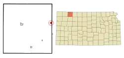 Location within Decatur County and Kansas | |
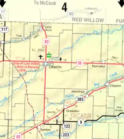 KDOT map of Decatur County (legend) | |
| Coordinates: 39°50′11″N 100°11′18″W | |
| Country | United States |
| State | Kansas |
| County | Decatur |
| Founded | 1885 |
| Incorporated | 1901 |
| Named for | Norton and Decatur counties |
| Area | |
| • Total | 1.00 sq mi (2.58 km2) |
| • Land | 1.00 sq mi (2.58 km2) |
| • Water | 0.00 sq mi (0.00 km2) |
| Elevation | 2,644 ft (806 m) |
| Population | |
| • Total | 151 |
| • Estimate (2019)[5] | 144 |
| • Density | 144.58/sq mi (55.85/km2) |
| Time zone | UTC-6 (CST) |
| • Summer (DST) | UTC-5 (CDT) |
| ZIP code | 67653 |
| Area code | 785 |
| FIPS code | 20-50925 [6] |
| GNIS ID | 471026 [7] |
History
Norcatur was founded in 1885. Norcatur was named from its location near the border between Norton and Decatur counties.[9]
The first post office in Norcatur was established in October, 1885.[10]
Geography
Norcatur is located at 39°50′11″N 100°11′18″W (39.836514, -100.188402).[11] According to the United States Census Bureau, the city has a total area of 0.99 square miles (2.56 km2), all land.[12]
Demographics
| Historical population | |||
|---|---|---|---|
| Census | Pop. | %± | |
| 1910 | 482 | — | |
| 1920 | 476 | −1.2% | |
| 1930 | 524 | 10.1% | |
| 1940 | 440 | −16.0% | |
| 1950 | 368 | −16.4% | |
| 1960 | 302 | −17.9% | |
| 1970 | 284 | −6.0% | |
| 1980 | 226 | −20.4% | |
| 1990 | 198 | −12.4% | |
| 2000 | 169 | −14.6% | |
| 2010 | 151 | −10.7% | |
| 2019 (est.) | 144 | [5] | −4.6% |
| U.S. Decennial Census | |||
2010 census
As of the census[4] of 2010, there were 151 people, 74 households, and 40 families living in the city. The population density was 152.5 inhabitants per square mile (58.9/km2). There were 101 housing units at an average density of 102.0 per square mile (39.4/km2). The racial makeup of the city was 98.7% White and 1.3% from two or more races. Hispanic or Latino of any race were 2.0% of the population.
There were 74 households, of which 12.2% had children under the age of 18 living with them, 43.2% were married couples living together, 6.8% had a female householder with no husband present, 4.1% had a male householder with no wife present, and 45.9% were non-families. 40.5% of all households were made up of individuals, and 13.6% had someone living alone who was 65 years of age or older. The average household size was 2.04 and the average family size was 2.73.
The median age in the city was 51.3 years. 17.9% of residents were under the age of 18; 7.2% were between the ages of 18 and 24; 14.6% were from 25 to 44; 33.8% were from 45 to 64; and 26.5% were 65 years of age or older. The gender makeup of the city was 56.3% male and 43.7% female.
2000 census
As of the census[6] of 2000, there were 169 people, 81 households, and 54 families living in the city. The population density was 169.0 people per square mile (65.3/km2). There were 104 housing units at an average density of 104.0 per square mile (40.2/km2). The racial makeup of the city was 100.00% White.
There were 81 households, out of which 17.3% had children under the age of 18 living with them, 60.5% were married couples living together, 4.9% had a female householder with no husband present, and 32.1% were non-families. 30.9% of all households were made up of individuals, and 19.8% had someone living alone who was 65 years of age or older. The average household size was 2.09 and the average family size was 2.58.
In the city, the population was spread out, with 16.6% under the age of 18, 2.4% from 18 to 24, 26.0% from 25 to 44, 22.5% from 45 to 64, and 32.5% who were 65 years of age or older. The median age was 51 years. For every 100 females, there were 79.8 males. For every 100 females age 18 and over, there were 93.2 males.
The median income for a household in the city was $24,750, and the median income for a family was $29,792. Males had a median income of $23,125 versus $16,250 for females. The per capita income for the city was $14,028. About 7.3% of families and 12.4% of the population were below the poverty line, including 9.5% of those under the age of eighteen and 23.8% of those 65 or over.
Education
The community is served by Oberlin USD 294 public school district.
Norcatur schools were closed in school unification. The Norcatur High School mascot was Norcatur Cardinals.[13]
Notable people
- Dewey Adkins, Major League Baseball player
- Elden Auker, Major League Baseball pitcher
References
- National and State Registers of Historic Places: Decatur County. Kansas Historical Society. Retrieved 2014-09-14.
- National and State Registers of Historic Places: Decatur County. Kansas Historical Society. Retrieved 2014-09-14.
- "2019 U.S. Gazetteer Files". United States Census Bureau. Retrieved July 24, 2020.
- "U.S. Census website". United States Census Bureau. Retrieved 2012-07-06.
- "Population and Housing Unit Estimates". United States Census Bureau. May 24, 2020. Retrieved May 27, 2020.
- "U.S. Census website". United States Census Bureau. Retrieved 2008-01-31.
- "US Board on Geographic Names". United States Geological Survey. 2007-10-25. Retrieved 2008-01-31.
- "2010 City Population and Housing Occupancy Status". U.S. Census Bureau. Retrieved September 14, 2011.
- Kansas State Historical Society (1916). Biennial Report of the Board of Directors of the Kansas State Historical Society. Kansas State Printing Plant. p. 174.
- "Kansas Post Offices, 1828-1961 (archived)". Kansas Historical Society. Archived from the original on October 9, 2013. Retrieved 8 June 2014.
- "US Gazetteer files: 2010, 2000, and 1990". United States Census Bureau. 2011-02-12. Retrieved 2011-04-23.
- "US Gazetteer files 2010". United States Census Bureau. Archived from the original on 2013-01-31. Retrieved 2012-07-06.
- "Good Year at Norcatur", The Hutchinson News, 1 April 1951, p.22.
Further reading
External links
| Wikimedia Commons has media related to Norcatur, Kansas. |
Municipalities and communities of Decatur County, Kansas, United States | ||
|---|---|---|
| Cities |  Map of Kansas highlighting Decatur County | |
| Unincorporated communities | ||
| Ghost towns | ||
| Townships | ||
| Footnotes | ‡This populated place also has portions in an adjacent county or counties | |
| ||