Norfork Tailwater
The Norfork Tailwater is the segment of the North Fork River below Norfork Dam in north central Arkansas. Near Salesville, Arkansas, the Norfork Tailwater is about 4.8 miles (7.7 km) long and stretches from the dam below Lake Norfork to the White River. The Norfork Tailwater is home to brown, rainbow, cutthroat, and brook trout, as well as other fish. A trout hatchery (the Norfork National Fish Hatchery) near Quarry Park keeps the tailwater stocked with trout, while the dam's cold water output provides suitable habitat for these cool-water game fish.
| Norfork Tailwater | |
|---|---|
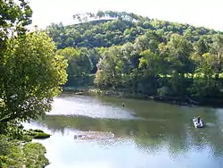 Norfork Tailwater, September 2006 | |
 Norfork Tailwater | |
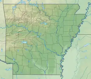
| Location | near Salesville, Arkansas |
| Coordinates | 36.246239°N 92.245481°W |
| Primary inflows | North Fork River, 100 to 6,000 cubic foot (2,800 to 169,900 L) per second from Norfork Dam[1] |
| Primary outflows | White River |
| Managing agency | Arkansas Game and Fish Commission, U.S. Army Corps of Engineers |
| Built | 1944 |
Access
The tailwater can be accessed in a few locations. Access is free below the dam from Highway 177. There are also a few private boat ramps and other properties that can be used to access the river with permission.
2008 flood
In response to the Spring 2008 Midwest floods the Army Corps of Engineers opened the dam floodgates on April 10.[2] The mass of water changed the river's depth in some places, and boaters and waders should use caution.
See also
 United States portal
References
- "Bull Shoals & Norfork Tailwaters Management Plan" (PDF). Arkansas Game and Fish Commission, Fisheries Division. April 17, 2008. p. 6. Archived from the original (PDF) on September 19, 2011. Retrieved August 28, 2012.
- "Little Rock Yearly Climate Summary". North Little Rock, AR: National Weather Service Weather Forecast Office. June 17, 2009. p. 1.
