Normanton, Queensland
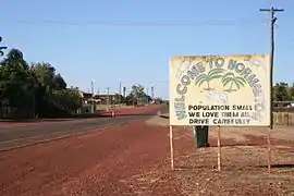
Normanton is a small outback cattle town and coastal locality in the Shire of Carpentaria in Queensland, Australia.[2] It is the administrative centre of the Shire. In the 2016 census, Normanton had a population of 1,210 people, of whom 743 were Indigenous Australians. It has a tropical savanna climate.
| Normanton Queensland | |||||||||||||||
|---|---|---|---|---|---|---|---|---|---|---|---|---|---|---|---|
 Entry into Normanton | |||||||||||||||
 Normanton | |||||||||||||||
| Coordinates | 17°40′0″S 141°04′0″E | ||||||||||||||
| Population | 1,210 (2016 census)[1] | ||||||||||||||
| Established | 1867 | ||||||||||||||
| Postcode(s) | 4890 | ||||||||||||||
| Location | |||||||||||||||
| LGA(s) | Shire of Carpentaria | ||||||||||||||
| State electorate(s) | Traeger | ||||||||||||||
| Federal Division(s) | Kennedy | ||||||||||||||
| |||||||||||||||
| |||||||||||||||
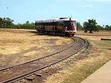
The town is one terminus of the isolated Normanton to Croydon railway line, which was built during gold rush days in the 1890s. The Gulflander passenger train operates once a week.
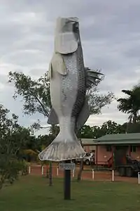
The "Big Barramundi" and a statue of a large saltwater crocodile are notable features of the town, along with many heritage-listed sites.
History
The town sits in the traditional lands of the Gkuthaarn (Kareldi) and Kukatj people.[3]
The town takes its current name from the Norman River, which was named in honour of William Henry Norman of the Victorian Naval Forces, who commanded a ship in the search for the explorers Burke and Wills and also conducted hydrographic surveys of the Gulf of Carpentaria and the Torres Strait to identify reefs and other marine hazards.[2]
The site for the town was selected after Burketown was abandoned owing to fever and flooding.[4] Settlers moved into the town in 1867.[5] Normanton attracted people from a variety of cultures, including Chinese people drawn to the gold fields.[4] The town prosperity was assisted by the establishment of a railway line in the late 1800s.[6]
Norman River Post Office opened on 13 June 1868 and was renamed Normanton by 1872.[7]
The town contains the longest intact and operating Burns Philp store in Queensland. The general mercantile store and agency office was opened in 1884.[8]
The population reached 1,251 by 1891.[9] The gold boom was short-lived. By 1947 the town's population had declined to 234.[9] After the gold ran out and the mining industry grew to a halt in the early 1900s, pastoralism became the main industry of the region.[6]
Some Aboriginal groups in the region were moved on to cattle stations to provide labour, while other groups were more or less extinguished. Many were moved to missions on Mornington Island and Doomadgee. Aboriginal camps were set up on the outskirts of the town, and the first Aboriginal reserve was gazetted in 1935; both were still in existence until at least 1976.[6]
The Normanton library was opened in 2004.[10]
Heritage listings
Normanton has a number of heritage-listed sites, including:
- Burke and Wills Access Road (Private Road): Burke and Wills Camp B/CXIX[11]
- Burke Developmental Road: Normanton Cemetery[12]
- 27 Haigh Street: Normanton Gaol[13]
- cnr Landsborough Street and Caroline Street: Burns Philp Building[14]
- Landsborough Street: Westpac Bank Building[15]
- Matilda Street: Normanton railway station[16]
- Normanton to Croydon: Normanton to Croydon railway line[17]
Geography
Normanton is in the Gulf Country region of northwest Queensland, just south of the Gulf of Carpentaria, on the Norman River in Queensland. It is a small cattle town and coastal locality, and administrative centre of the Shire of Carpentaria.[2][18][4]
An unusual feature 106 kilometres (66 mi) southwest of Normanton is Bang Bang Jump Up, one of the few hills located in the middle of an expansive, flat grassland.[19]
Demographics
In 2006 census, the town's population was 1,100, 60 per cent identifying as Aboriginal and/or Torres Strait Islander people.[20]
In the 2016 census, Normanton had a population of 1,210 people, of whom 743 identified as Aboriginal and/or Torres Strait Islander people.[1]
Industry
Like other Gulf communities, the prawning industry makes an important economic contribution to the town. Tourism has recently become an important part of the economy of Normanton, with Gulflander a significant draw-card.[9]
Attractions
Among Normanton's most notable features is a statue[21] of an 8.64-metre (28.3 ft) long saltwater crocodile named Krys, the largest ever taken, which was shot by Krystina Pawlowska in July 1957 in the Norman River.[22]
"The Big Barramundi", which is 6 metres (20 ft) long, is also located in the town.[23]
Barramundi and threadfin salmon can be caught in the river.[24]
Amenities
Normanton has a sports centre, golf course, bowling green, gun club, racecourse, rodeo ground, and an aerodrome.[25]
Normanton public library and visitor information services are located in the historic Burns Philp Building at the corner of Caroline and Landsborough Streets.[26]
The Normanton branch of the Queensland Country Women's Association has its rooms in Landsborough Street.[27]
Normanton State School opened on 8 September 1882.[28] The school celebrated its centenary in 1982.[29]
Our Lady Help of Christians Catholic Church is at 23 Dutton Street. It is within the Gulf Savannah Parish of the Roman Catholic Diocese of Cairns.[30]
Native title
After seeking rights since 1996, in November 2012 the traditional owners, the Gkuthaarn and Kukatj people, lodged a claim for native title over an area around Normanton stretching 16,000 square kilometres (6,200 sq mi). On 2 July 2020 an Indigenous Land Use Agreement (ILUA) was signed,[31] and they were granted rights to fish, hunt and perform their ceremonies on the land. Pastoralists are still able to run cattle on the cattle stations in the area, and the Aboriginal people assist with management of the land (such as pest and weed control) and cultural heritage sites. They are already monitoring and counting of migratory seabirds, with many participating as Indigenous rangers in the Normanton Land and Sea Ranger Group. Some land in the southern part of the claimed area has been determined as "native title extinguished".[3][32]
Transport
6 kilometres (3.7 mi) south of the town is the start of the Gulf Developmental Road, part of the Savannah Way tourist drive.
The Gulflander passenger train operates weekly on a 151 km (94 mi) remnant of the Normanton to Croydon historical railway. The Normanton railway station features a large steel frame with an open canopy to provide shade.[5]
Climate
Normanton has a tropical savanna climate (Aw) with two distinct seasons. There is a hot, humid and extremely uncomfortable wet season from December to March and a hot and generally rainless dry season usually extending from April to November. During the wet season most roads in the area are usually closed by heavy rainfall, which on several occasions has exceeded 650 millimetres (26 in) in a month or 250 millimetres (10 in) in a day from tropical cyclones. On occasions, as with all of Queensland, the wet season may fail and deliver as little as 240 millimetres (9.4 in) between December 1934 and March 1935[33]
Temperatures are uniformly hot, ranging from 36.8 °C (98 °F) in November just before the wet season begins to 29 °C (84 °F) at the height of the dry season in July. In the wet season, temperatures are marginally lower, but extremely high humidity means conditions are very uncomfortable and wet bulb temperatures averages 25 °C (77 °F) and can reach 28 °C (82 °F). In the dry season, lower humidity, cloudless days and cool nights provides for more pleasant conditions.
| Climate data for Normanton Post Office, Queensland | |||||||||||||
|---|---|---|---|---|---|---|---|---|---|---|---|---|---|
| Month | Jan | Feb | Mar | Apr | May | Jun | Jul | Aug | Sep | Oct | Nov | Dec | Year |
| Record high °C (°F) | 43.1 (109.6) |
41.0 (105.8) |
40.1 (104.2) |
39.5 (103.1) |
37.2 (99.0) |
35.6 (96.1) |
35.6 (96.1) |
38.3 (100.9) |
40.1 (104.2) |
41.8 (107.2) |
43.3 (109.9) |
43.3 (109.9) |
43.3 (109.9) |
| Average high °C (°F) | 34.7 (94.5) |
33.9 (93.0) |
34.2 (93.6) |
34.0 (93.2) |
31.7 (89.1) |
29.2 (84.6) |
29.1 (84.4) |
31.1 (88.0) |
33.9 (93.0) |
35.9 (96.6) |
36.8 (98.2) |
36.1 (97.0) |
33.4 (92.1) |
| Average low °C (°F) | 25.1 (77.2) |
24.9 (76.8) |
24.4 (75.9) |
22.4 (72.3) |
19.1 (66.4) |
16.1 (61.0) |
15.2 (59.4) |
16.5 (61.7) |
19.5 (67.1) |
22.6 (72.7) |
24.7 (76.5) |
25.3 (77.5) |
21.3 (70.3) |
| Record low °C (°F) | 18.3 (64.9) |
17.3 (63.1) |
16.7 (62.1) |
14.4 (57.9) |
7.2 (45.0) |
6.7 (44.1) |
7.0 (44.6) |
6.6 (43.9) |
11.1 (52.0) |
13.7 (56.7) |
15.5 (59.9) |
18.9 (66.0) |
6.6 (43.9) |
| Average rainfall mm (inches) | 260.2 (10.24) |
249.2 (9.81) |
157.7 (6.21) |
30.9 (1.22) |
7.5 (0.30) |
9.2 (0.36) |
3.2 (0.13) |
1.7 (0.07) |
3.0 (0.12) |
10.5 (0.41) |
45.1 (1.78) |
144.4 (5.69) |
922.6 (36.34) |
| Average rainy days (≥ 0.2 mm) | 13.9 | 13.9 | 9.4 | 2.4 | 0.9 | 0.7 | 0.5 | 0.3 | 0.4 | 1.3 | 4.4 | 9.0 | 57.1 |
| Average relative humidity (%) | 74 | 78 | 70 | 57 | 52 | 52 | 48 | 44 | 45 | 49 | 54 | 65 | 57 |
| Source: [34] | |||||||||||||

See also
References
- Australian Bureau of Statistics (27 June 2017). "Normanton (UCL)". 2016 Census QuickStats. Retrieved 15 November 2017.

- "Normanton – town (entry 43962)". Queensland Place Names. Queensland Government. Retrieved 5 July 2016.
- Gordon, Krystal; Faa, Marian (30 September 2020). "Traditional owners granted native title rights in Gulf of Carpentaria". ABC News. Australian Broadcasting Corporation. Archived from the original on 1 October 2020. Retrieved 10 October 2020.
- Environmental Protection Agency (Queensland) (2002). Heritage Trails of the Queensland Outback. State of Queensland. p. 94. ISBN 0-7345-1040-3.
- Cook, Penny (2006). Discover Queensland Heritage. Corinda, Queensland: Pictorial Press Australia. p. 18. ISBN 1876561424.
- "The History". Southern Gulf Natural Resource Management. 20 April 2016. Retrieved 5 December 2020.
- Premier Postal History. "Post Office List". Premier Postal Auctions. Archived from the original on 15 May 2014. Retrieved 10 May 2014.
- Brian Williams (24 October 2011). "Queensland's earliest surviving Burns Philp store at Normanton, Gulf of Carpentaria, to be heritage-listed". The Courier-Mail. News Queensland. Archived from the original on 10 October 2020. Retrieved 11 December 2012.
- "Travel: Normanton". The Sydney Morning Herald. Fairfax Media. 8 February 2004. Archived from the original on 31 May 2014. Retrieved 11 December 2012.
- "Public Libraries Statistical Bulletin 2016-17" (PDF). Public Libraries Connect. State Library of Queensland. November 2017. p. 12. Archived (PDF) from the original on 30 January 2018. Retrieved 15 January 2018.
- "Burke and Wills' Camp B/CXIX and Walker's Camp, Little Bynoe River (entry 602156)". Queensland Heritage Register. Queensland Heritage Council. Retrieved 7 July 2013.
- "Normanton Cemetery (entry 601157)". Queensland Heritage Register. Queensland Heritage Council. Retrieved 7 July 2013.
- "Normanton Gaol (entry 601501)". Queensland Heritage Register. Queensland Heritage Council. Retrieved 7 July 2013.
- "Burns Philp Building (former) (entry 602781)". Queensland Heritage Register. Queensland Heritage Council. Retrieved 7 July 2013.
- "Westpac Bank, Normanton (entry 600394)". Queensland Heritage Register. Queensland Heritage Council. Retrieved 7 July 2013.
- "Normanton Railway Terminus (entry 600395)". Queensland Heritage Register. Queensland Heritage Council. Retrieved 7 July 2013.
- "Normanton to Croydon Railway Line (entry 600396)". Queensland Heritage Register. Queensland Heritage Council. Retrieved 7 July 2013.
- "Normanton – locality (entry 44655)". Queensland Place Names. Queensland Government. Retrieved 5 July 2016.
- "Normanton > Attractions". Explore Australia Publishing. Archived from the original on 11 July 2017. Retrieved 13 June 2017.
- Australian Bureau of Statistics (25 October 2007). "Normanton (Urban Centre/Locality)". 2006 Census QuickStats. Retrieved 3 May 2009.
- "Image: 1.1318938577.krys-the-savannah-king.jpg, (550 × 413 px)". images.travelpod.com. 3 October 2007. Archived from the original on 21 December 2015. Retrieved 4 September 2015. Photograph taken from 27°28′3.36″S 153°1′40.8″E.
- "Death of a monster". The Australian. 25 November 2008. Archived from the original on 24 April 2013. Retrieved 4 September 2015.
- "Big Barramundi". The Courier-Mail. News Queensland. Archived from the original on 24 March 2012. Retrieved 11 December 2012.
- Groover, Gavin (31 January 2017). "Carpentaria Barra and Sport Fishing Charters". Carpentaria Barra and Sport Fishing Charters. Archived from the original on 2 February 2017. Retrieved 30 January 2017.
- "Normanton". Centre for the Government of Queensland. Archived from the original on 5 March 2011. Retrieved 17 January 2011.
- "Visitor Information Centres and Libraries". Carpentaria Shire Council. Archived from the original on 15 January 2018. Retrieved 15 January 2018.
- "Branch locations". Queensland Country Women's Association. Archived from the original on 26 December 2018. Retrieved 26 December 2018.
- "Opening and closing dates of Queensland Schools". Queensland Government. Retrieved 18 April 2019.
- O'Neill, Brian W; Normanton State School, A unique school in the Gulf : a study of the influence of the pastoral and mining industries on education in the Gulf, with particular reference to Normanton / compiled by Brian W. O'Neill, W.J. & J.M. O'Neill
- "Gulf Savannah Parish". Roman Catholic Diocese of Cairns. Archived from the original on 18 November 2020. Retrieved 18 November 2020.
- "QI2020/003 - Carpentaria Shire Council Gkuthaarn and Kukatj ILUA". National Native Title Tribunal. Register of Indigenous Land Use Agreements Details. Retrieved 10 October 2020.
- "QI2020/002 - Gkuthaarn and Kukatj People Tenure Resolution ILUA". National Native Title Tribunal. Register of Indigenous Land Use Agreements Details. Retrieved 10 October 2020.
- "Monthly Rainfall - 029041 - Bureau of Meteorology | Normanton Post Office". bom.gov.au. Archived from the original on 24 September 2015. Retrieved 4 September 2015.
- "Climate statistics for Australian locations – Normanton Post Office (1872–2001)". bom.gov.au. Archived from the original on 23 September 2015. Retrieved 4 September 2015.