North Carolina Highway 83
North Carolina Highway 83 (NC 83) is a primary state highway in the U.S. state of North Carolina. It serves to connect the towns of Maxton and Clio, South Carolina.
| ||||
|---|---|---|---|---|
 | ||||
| Route information | ||||
| Maintained by NCDOT | ||||
| Length | 7.285 mi[1] (11.724 km) | |||
| Existed | 1937–present | |||
| Major junctions | ||||
| South end | ||||
| North end | ||||
| Location | ||||
| Counties | Robeson | |||
| Highway system | ||||
| ||||

Route description
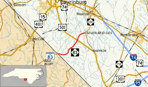
NC 83 is a two-lane 7.285-mile-long (11.724 km) rural highway that begins at the South Carolina state line and goes north to end at NC 130 in Seven Bridges. The highway is flanked by both farmland and swamps.[2]
History
NC 83 was established in 1937 as a new primary routing from US 501 to the South Carolina state line, where it continues as SC 83.[3] In 1947, it was extended north to its current terminus at NC 130 in Seven Bridges.[4]
Major intersections
The entire route is in Robeson County.
| Location | mi[2] | km | Destinations | Notes | |
|---|---|---|---|---|---|
| | 0.0 | 0.0 | South Carolina state line | ||
| | 5.0 | 8.0 | |||
| Seven Bridges | 7.3 | 11.7 | |||
| 1.000 mi = 1.609 km; 1.000 km = 0.621 mi | |||||
References
- "NCDOT GIS Data Layers". North Carolina Department of Transportation. 2012. Retrieved December 28, 2012.
- Google (December 28, 2012). "North Carolina Highway 83" (Map). Google Maps. Google. Retrieved December 28, 2012.
- North Carolina Primary Highway System (PDF) (Map). Cartography by NCDOT. North Carolina Department of Transportation. 1940. Retrieved June 11, 2014.
- North Carolina Official Highway Map (PDF) (Map). Cartography by NCDOT. North Carolina Department of Transportation. 1951. Retrieved June 11, 2014.
External links
 Media related to North Carolina Highway 83 at Wikimedia Commons
- NCRoads.com: N.C. 83
This article is issued from Wikipedia. The text is licensed under Creative Commons - Attribution - Sharealike. Additional terms may apply for the media files.