North Carolina Highway 130
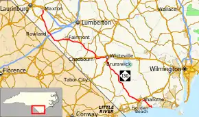
North Carolina Highway 130 (NC 130) is a primary state highway in the U.S. state of North Carolina. The highway serves the towns and rural communities in southern Robeson County, acts as a direct route between Whiteville and Shallotte through the Green Swamp, and provides access to Holden Beach.
| ||||
|---|---|---|---|---|
 | ||||
| Route information | ||||
| Maintained by NCDOT | ||||
| Length | 101.5 mi[1] (163.3 km) | |||
| Existed | 1928–present | |||
| Major junctions | ||||
| West end | ||||
| ||||
| East end | Ocean Boulevard in Holden Beach | |||
| Location | ||||
| Counties | Robeson, Columbus, Brunswick | |||
| Highway system | ||||
| ||||

Route description
NC Highway 130 begins at U.S. Route 74 Business (US 74 Bus.) and NC 71 in Maxton and ends at Ocean Boulevard in Holden Beach.
It overlaps several highways along its route, including US 501, US 74 (proposed Interstate 74), US 76, NC 410 and US 17 Bus.
History
NC 130 was established around 1928 as a renumbering of part of NC 201 between NC 30 in Supply, to the intersection of Moore Street and Atlantic Avenue in Southport. In 1930, NC 130 was extended west along NC 30 to Shallotte, then northwest along new primary routing to NC 23 near Whiteville.[2] In 1940, NC 130 made its final westward extension, by overlapping with US 701 to US 74 in Whiteville; in concurrency, it travels with US 74 until Boardman, then replaced NC 71 through Fairmont and Rowland before ending at US 74/NC 71 in Maxton.[3]
By 1944, NC 130 was rerouted in Shallotte onto Whiteville Road and Powell Street to US 17 on Village Road; its old alignment of Bridger Road and Mulberry Street was downgraded to secondary roads. In 1949, NC 130 was extended north on new primary routing from Southport, through the Sunny Point Army Terminal (opened 1955) and Orton Plantation, to US 17/US 74/US 76 in Belville.[4] In 1957, NC 130 was truncated in Shallotte; with Supply to Southport becoming part of NC 211 and Southport to Belville part of NC 40. In 1959, NC 130 was extended on new primary routing to Holden Beach.[5] By 1962, NC 130 was adjusted onto Main Street instead of Village Road in Shallotte, downgrading Powell Street to secondary road.[6]
In 1965, NC 130 was rerouted on new bypass southeast of Fairmont, with its old alignment through town becoming NC 130 Business.[7] In 1972, US 74/NC 130 was placed on new alignment between the Lumber River and Chadbourn; its old alignment through Boardman and Evergreen became Old US 74 (SR 1574).[8] In 1975, US 74/NC 130 was rerouted onto new alignment north of Chadbourn to NC 410, where then continued together south into town; five months later, the concurrencies would change to US 74 Bus. and US 76 Bus. between Chadbourn and Whiteville.[9][10] NC 130 was rerouted in 2012 onto new four-lane Smith Avenue in Shallotte; NC 130 Business was established continuing along the old alignment with US 17 Bus. and onto Holden Beach Road, then on new routing on Edgewater Drive back to the mainline.[11]
Junction list
| County | Location | mi[1] | km | Destinations | Notes |
|---|---|---|---|---|---|
| Robeson | Maxton | 0.0 | 0.0 | ||
| Seven Bridges | 3.8 | 6.1 | |||
| Raemon | 7.9 | 12.7 | North end of US 501 overlap | ||
| | 14.1 | 22.7 | |||
| Rowland | 15.4 | 24.8 | South end of US 501 overlap | ||
| | 16.7 | 26.9 | I-95 exit 2 | ||
| Five Forks | 22.9 | 36.9 | |||
| | 25.7 | 41.4 | |||
| Fairmont | 28.0 | 45.1 | |||
| | 29.5 | 47.5 | |||
| | 37.0 | 59.5 | West end of US 74 overlap | ||
| Columbus | Evergreen | 42.7 | 68.7 | Future I-74 exit 228 | |
| Chadbourn | 47.5 | 76.4 | East end of US 74, west end of US 74 Bus. and north end of NC 410 overlaps; Future I-74 exit 233 | ||
| 49.2 | 79.2 | West end of US 76 Bus. overlap | |||
| 49.4 | 79.5 | South end of NC 410 overlap | |||
| Whiteville | 56.5 | 90.9 | East end of US 74 Bus. / US 76 Bus. and north end of US 701 overlap | ||
| 59.1 | 95.1 | South end of US 701 and .04-mile (0.064 km) overlap of US 701 Bus. | |||
| Pleasant Plains | 64.3 | 103.5 | |||
| Brunswick | Shallotte | 90.4 | 145.5 | Partial cloverleaf interchange | |
| 91.3 | 146.9 | South end of US 17 Bus. overlap | |||
| 92.4 | 148.7 | North end of US 17 Bus. overlap | |||
| 93.1 | 149.8 | ||||
| Intracoastal Waterway | 101.3 | 163.0 | Holden Beach Bridge | ||
| Holden Beach | 101.5 | 163.3 | Ocean Boulevard | ||
1.000 mi = 1.609 km; 1.000 km = 0.621 mi
| |||||
Special routes
Fairmont business loop
| |
|---|---|
| Location | Fairmont, North Carolina |
| Length | 4.5 mi[12] (7.2 km) |
| Existed | 1965–present |
North Carolina Highway 130 Business (NC 130 Bus.) is a 4.5 miles (7.2 km) business loop that goes through downtown Fairmont, via Iona Street, Main Street and Cottage Street; it also shares a short concurrency with NC 41. It was established in 1965 when mainline NC 130 was moved to a bypass route south of town.[7]
The entire route is in Robeson County.
| Location | mi[12] | km | Destinations | Notes | |
|---|---|---|---|---|---|
| | 0.0 | 0.0 | |||
| Fairmont | 2.8 | 4.5 | North end of NC 41 overlap | ||
| 2.9 | 4.7 | South end of NC 41 overlap | |||
| | 4.5 | 7.2 | |||
1.000 mi = 1.609 km; 1.000 km = 0.621 mi
| |||||
Shallotte alternate spur
| |
|---|---|
| Location | Shallotte, North Carolina |
| Length | 0.20 mi[13] (0.32 km) |
| Existed | 1944–1962 |
North Carolina Highway 130A (NC 130A) was established in 1944 as cutoff between NC 130 and US 17 (today Village Road). By 1962, US 17 was rerouted onto new primary highway in Shallotte, thus decommissioning the cutoff as NC 130 was adjusted further west.[14]
Shallotte business loop
| |
|---|---|
| Location | Shallotte, North Carolina |
| Length | 0.60 mi[15] (0.97 km) |
| Existed | 2012–present |
North Carolina Highway 130 Business (NC 130 Bus) is a 0.6-mile (0.97 km) business loop in Shallotte.[11]
The entire route is in Shallotte, Brunswick County.
| mi[15] | km | Destinations | Notes | ||
|---|---|---|---|---|---|
| 0.0 | 0.0 | South end of US 17 Bus. overlap | |||
| 0.2 | 0.32 | North end of US 17 Bus. overlap | |||
| 0.6 | 0.97 | ||||
1.000 mi = 1.609 km; 1.000 km = 0.621 mi
| |||||
References
- Google (March 7, 2016). "North Carolina Highway 130" (Map). Google Maps. Google. Retrieved March 7, 2016.
- State Highway System of North Carolina (PDF) (Map). Cartography by NCSHC. North Carolina State Highway Commission. 1930. Retrieved March 7, 2016.
- North Carolina Primary Highway System (PDF) (Map). Cartography by NCSHC. North Carolina State Highway and Public Works Commission. 1940. Retrieved March 7, 2016.
- North Carolina County Road Survey 1949 (PDF) (Map). Cartography by NCSHC / U.S. Bureau of Public Roads. North Carolina State Highway Commission. 1949. Retrieved March 7, 2016.
- North Carolina Primary Highway System (PDF) (Map). Cartography by NCSHC. North Carolina State Highway and Public Works Commission. 1960. Retrieved March 7, 2016.
- North Carolina County Road Survey 1962 (PDF) (Map). Cartography by NCSHC / U.S. Bureau of Public Roads. North Carolina State Highway Commission. 1962. Retrieved March 7, 2016.
- "Route Change (1965-10-08)" (PDF). North Carolina Department of Transportation. October 8, 1965. Retrieved March 7, 2016.
- "Route Change (1972-10-05)" (PDF). North Carolina Department of Transportation. October 5, 1972. Retrieved March 7, 2016.
- "Route Change (1975-09-01)" (PDF). North Carolina Department of Transportation. September 1, 1975. Retrieved March 7, 2016.
- "Route Change (1976-02-01)" (PDF). North Carolina Department of Transportation. February 1, 1976. Retrieved March 7, 2016.
- "Route Change (2012-02-20)" (PDF). North Carolina Department of Transportation. February 20, 2012. Retrieved March 7, 2016.
- Google (December 30, 2013). "North Carolina Highway 130 Business - Fairmont" (Map). Google Maps. Google. Retrieved December 30, 2013.
- Google (June 6, 2014). "North Carolina Highway 130A" (Map). Google Maps. Google. Retrieved June 6, 2014.
- North Carolina County Road Survey 1944 (PDF) (Map). Cartography by NCSHC / U.S. Bureau of Public Roads. North Carolina State Highway Commission. 1944. Retrieved March 7, 2016.
- Google (March 7, 2016). "North Carolina Highway 130 Business - Shallotte" (Map). Google Maps. Google. Retrieved March 7, 2016.
External links
 Media related to North Carolina Highway 130 at Wikimedia Commons
- NCRoads.com: N.C. 130
- NCRoads.com: N.C. 130-A
- NCRoads.com: N.C. 130 Bus