North Carolina Highway 904
North Carolina Highway 904 (NC 904) is a primary state highway in the U.S. state of North Carolina. The highway parallels the North Carolina-South Carolina border as it connects Fair Bluff, Tabor City, Sunset Beach, and Ocean Isle Beach.
| ||||
|---|---|---|---|---|
 | ||||
| Route information | ||||
| Maintained by NCDOT | ||||
| Length | 67.5 mi[1] (108.6 km) | |||
| Existed | 1937–present | |||
| Major junctions | ||||
| West end | ||||
| ||||
| East end | First Street in Ocean Isle Beach | |||
| Location | ||||
| Counties | Robeson, Columbus, Brunswick | |||
| Highway system | ||||
| ||||

Description
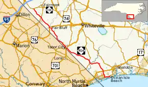
NC 904 is a 67.5-mile (108.6 km) east–west highway (physically running northwest–southeast) that travels from NC 130 in Five Forks, to East First Street in Ocean Isle Beach. It passes through Brunswick, Columbus, and Robeson Counties.[1]
History
Established in 1937 as a renumbering of NC 761 when it was extended into South Carolina, south of Tabor City, continuing as SC 904. Around 1951, US 701 was rerouted at Tabor City, replacing NC 904 into South Carolina; its former alignment became an extension of NC 410. In 1954, NC 904 was extended west on new primary routing to its current western terminus with NC 130 in Five Forks. By 1958, NC 904 was extended onto new primary routing east to Seaside; by 1963, it was extended again to its current eastern terminus in Ocean Isle Beach.
North Carolina Highway 761
| |
|---|---|
| Location | Fair Bluff–Tabor City, NC |
| Length | 15.6 mi[2] (25.1 km) |
| Existed | 1935–1937 |
North Carolina Highway 761 (NC 761) was established 1935 as new primary routing from US 76 in Fair Bluff, to US 701 in Tabor City. In 1937, it was renumbered as NC 904 when the highway was extended into South Carolina to sync with SC 904.
Major intersections
| County | Location | mi[1] | km | Destinations | Notes |
|---|---|---|---|---|---|
| Robeson | Five Forks | 0.0 | 0.0 | Western terminus | |
| Marietta | 6.9 | 11.1 | |||
| Columbus | Fair Bluff | 15.0 | 24.1 | Western end of US 76 concurrency | |
| 15.3 | 24.6 | Eastern end of US 76 concurrency | |||
| Tabor City | 30.9 | 49.7 | Western end of US 701 Bus./NC 410 concurrency | ||
| 31.2 | 50.2 | Eastern end of US 701 Bus./NC 410 concurrency | |||
| 31.9 | 51.3 | ||||
| Pireway | 48.0 | 77.2 | Western end of NC 905 concurrency | ||
| 48.5 | 78.1 | Western end of NC 905 concurrency | |||
| Brunswick | Grisettown | 60.0 | 96.6 | ||
| Calabash | 62.2 | 100.1 | Western end of NC 179 concurrency | ||
| Seaside | 63.6 | 102.4 | Northern terminus of NC 179 Bus. | ||
| Ocean Isle Beach | 66.3 | 106.7 | Eastern end of NC 179 concurrency | ||
| 66.5 | 107.0 | Odell Williamson Bridge over the Intracoastal Waterway | |||
| 67.7 | 109.0 | First Street | Eastern terminus; roundabout | ||
1.000 mi = 1.609 km; 1.000 km = 0.621 mi
| |||||
References
- Google (June 16, 2013). "North Carolina Highway 904" (Map). Google Maps. Google. Retrieved June 16, 2013.
- Google (June 16, 2013). "North Carolina Highway 761" (Map). Google Maps. Google. Retrieved June 16, 2013.
External links
 Media related to North Carolina Highway 904 at Wikimedia Commons
- NCRoads.com: N.C. 761
- NCRoads.com: N.C. 904