North Fork Smoky Hill River
The North Fork Smoky Hill River is a river in the central Great Plains of North America. A tributary of the Smoky Hill River, it flows from eastern Colorado into western Kansas.[2][3]
| North Fork Smoky Hill River | |
|---|---|
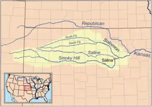
 Map of the Smoky Hill drainage basin | |
| Location | |
| Country | United States |
| State | Colorado, Kansas |
| Physical characteristics | |
| Source | |
| • location | Cheyenne County, Colorado |
| • coordinates | 39°02′06″N 102°48′28″W |
| • elevation | 4,811 ft (1,466 m) |
| Mouth | Smoky Hill River |
• location | Logan County, Kansas |
• coordinates | 38°55′13″N 101°16′51″W[1] |
• elevation | 2,940 ft (900 m) |
| Length | 195 mi (314 km) |
| Basin size | 759 sq mi (1,970 km2) |
| Basin features | |
| Watersheds | North Fork Smoky Hill-Smoky Hill-Kansas-Missouri-Mississippi |
Geography
The North Fork Smoky Hill River rises in the High Plains region of the Great Plains.[4] Its source lies in extreme northern Cheyenne County, Colorado 29 miles (47 km) west-northwest of Cheyenne Wells, the county seat. From there, the river flows east then east-northeast into Kansas.[2] In south-central Sherman County, it has been dammed to form a small reservoir, Sherman State Fishing Lake.[5][6] A few miles east of the reservoir, the river turns southeast and continues to its confluence with the Smoky Hill River in central Logan County 5 miles (8.0 km) west of Russell Springs.[3]
The river has a total length of 195 miles (314 km) and drains an area of 759 square miles (1,970 km2).[7]
Hydrology
The river is intermittent with water flowing only during and after rains.[8]
References
- "North Fork Smoky Hill River". Geographic Names Information System. United States Geological Survey. Retrieved 2011-02-01.
- "Colorado Travel Map" (PDF). Colorado Department of Transportation. Retrieved 2015-12-08.
- "2003-2004 Official Transportation Map" (PDF). Kansas Department of Transportation. Retrieved 2015-12-08.
- "Physiographic Provinces of Colorado". Colorado Geological Survey. Retrieved 2015-12-08.
- "General Highway Map - Sherman County, Kansas". Kansas Department of Transportation. November 2011. Retrieved 2015-12-08.
- "Sherman State Fishing Lake Fishing Information". Kansas Department of Wildlife, Parks and Tourism. Retrieved 2015-12-08.
- U.S. Geological Survey. National Hydrography Dataset high-resolution flowline data. The National Map, accessed March 29, 2011
- "Geohydrology of Sherman County". Kansas Geological Survey. Retrieved 2015-12-09.