North Toe River
The North Toe River is the headwaters of the Nolichucky River and a tributary in the French Broad River basin. From its source at Sugar Gap, between Bald Mountain and Sugar Mountain, it flows 73.6 miles (118.4 km) westerly through Avery, Mitchell, and Yancey counties.
| North Toe River | |
|---|---|
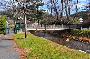
 Bridge over the North Toe River in Newland | |
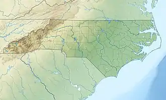
 Location of the mouth of North Toe River in North Carolina | |
| Location | |
| Country | United States |
| State | North Carolina |
| Counties | Avery, Mitchell, Yancey |
| Physical characteristics | |
| Source | Sugar Gap[1] |
| • location | Sugar Mountain, North Carolina |
| • coordinates | 36°07′47″N 81°53′13″W[2] |
| • elevation | 4,350 ft (1,330 m) |
| Mouth | Nolichucky River |
• location | Huntdale, North Carolina |
• coordinates | 36°01′44″N 82°19′37″W[2] |
• elevation | 2,021 ft (616 m)[2] |
| Length | 73.6 mi (118.4 km)[3] |
| Basin size | 1,146.22 square miles (2,968.7 km2)[3] |
| Basin features | |
| Progression | North Toe → Nolichucky → French Broad → Tennessee → Ohio → Mississippi → Gulf of Mexico |
| River system | French Broad River |
| Tributaries | |
| • left | Kentucky Creek, Cow Camp Creek, Haw Branch, Row Branch, Squirrel Creek, Plumtree Creek, Pancake Branch, Clear Creek, Threemile Creek, Brushy Creek, Laurel Creek, Harris Creek, White Oak Branch, Rose Creek, Cathis Creek, Grassy Creek, English Creek, Big Branch, Wolf Branch, South Toe River, Chestnut Branch, Brush Creek, Pigpen Creek, Jacks Creek, Bee Branch, McKinney Branch, Cane River |
| • right | Hickorynut Branch, Whiteoak Creek, Banjo Branch,Fall Branch, Horse Branch, Gooseneck Branch, Birchfield Creek, Race Path Branch, Whitaker Branch, Roaring Creek, Powdermill Creek, Doublehead Creek, Henson Creek, Justice Creek, Puatt Creek, Jones Creek, Little Laurel Branch, Bill Davenport Branch, Jake Creek, Beaver Creek, Pine Branch, Little Bear Creek, Lily Branch, Gouge Branch, Sink Hole Creek, Rose Creek, Cane Creek, Whitson Branch, Big Rock Creek, Raccoon Creek, Warrick Branch, Brummett Creek, Pigeonroost Creek, Cooper Branch, Rebels Creek |
History
The earliest inhabitants in the Toe River valley area were both the Catawba and Cherokee Indians; though neither lived in the area permanently, it is believed both tribes used the area as a hunting ground.[4] In 1540, the first European to the area was the Spanish explorer Hernando de Soto. Evidence of his visit includes Spanish mining at the Sink Hole, Clarissa, and Horse Stomp mines in Mitchell County. In the late 1560s, Spanish explorer Juan Pardo also visited the area in an attempt to establish a land route to Zacatecas in present-day Mexico.[5] In the 18th century, English, Scotch-Irish, and German settlers came to the area.[6][7][8]
Pollution
With Spruce Pine being the dividing line, the river upstream is considered in good health with a few tributaries impacted related to agricultural and development runoff. Downstream, the river has been impacted by legal and illegal wastewater discharges from mining operations in the area.[9] In 2018, Quartz Corp. illegally discharged hundreds of gallons of hydrofluoric acid into the North Toe River causing a fish kill.[10]
See also
References
- "Sugar Gap". Geographic Names Information System. United States Geological Survey. June 17, 1980. Retrieved December 28, 2020.
- "North Toe River". Geographic Names Information System. United States Geological Survey. June 17, 1980. Retrieved December 28, 2020.
- "ArcGIS Web Application". epa.maps.arcgis.com. US EPA. Retrieved December 29, 2020.
- "The Land Before Time - Native Americans in the Toe River Valley". Mitchell County Historical Society. October 17, 2016. Retrieved December 31, 2020.
- "The Europeans Arrive – Hernando DeSoto and the Spanish in the Toe River Valley". Mitchell County Historical Society. October 17, 2016. Retrieved December 31, 2020.
- Mazzocchi, Jay (2006). "Avery County". NCpedia. Retrieved December 31, 2020.
- Mazzocchi, Jay (2006). "Mitchell County". NCpedia. Retrieved December 31, 2020.
- Mazzocchi, Jay (2006). "Yancey County". NCpedia. Retrieved December 31, 2020.
- "Chapter 3 Nolichucky River" (PDF). North Carolina Department of Environment and Natural Resources. Retrieved December 30, 2020.
- Chávez, Karen (April 30, 2019). "Spruce Pine mining company that polluted North Toe River up for NC DEQ permit renewal". Asheville Citizen-Times. Retrieved December 30, 2020.