Northfield, Ohio
Northfield is a village in Summit County, Ohio, United States. The population was 3,677 at the 2010 census. It is part of the Akron Metropolitan Statistical Area.
Northfield, Ohio | |
|---|---|
 Location in Summit County and the state of Ohio. | |
| Coordinates: 41°20′31″N 81°31′51″W | |
| Country | United States |
| State | Ohio |
| County | Summit |
| Government | |
| • Mayor | Jesse J. Nehez |
| Area | |
| • Total | 1.05 sq mi (2.72 km2) |
| • Land | 1.05 sq mi (2.71 km2) |
| • Water | 0.00 sq mi (0.01 km2) |
| Elevation | 1,050 ft (320 m) |
| Population | |
| • Total | 3,677 |
| • Estimate (2019)[4] | 3,663 |
| • Density | 3,498.57/sq mi (1,350.35/km2) |
| Time zone | UTC-5 (Eastern (EST)) |
| • Summer (DST) | UTC-4 (EDT) |
| ZIP codes | 44056, 44067 |
| Area code(s) | 330 |
| FIPS code | 39-56448[5] |
| GNIS feature ID | 1043984[2] |
| Website | http://www.northfieldvillage-oh.gov/ |
History
A post office called Northfield has been in operation since 1837.[6] Some say the name is a transfer from Northfield, Massachusetts, while others believe the town site's location in the northern part of Summit County caused the name to be selected.[7]
Geography
Northfield is located at 41°20′31″N 81°31′51″W (41.341978, -81.530957).[8]
According to the United States Census Bureau, the village has a total area of 1.08 square miles (2.80 km2), all land.[9]
Demographics
| Historical population | |||
|---|---|---|---|
| Census | Pop. | %± | |
| 1920 | 861 | — | |
| 1930 | 1,750 | 103.3% | |
| 1940 | 575 | −67.1% | |
| 1950 | 780 | 35.7% | |
| 1960 | 1,055 | 35.3% | |
| 1970 | 4,283 | 306.0% | |
| 1980 | 3,913 | −8.6% | |
| 1990 | 3,624 | −7.4% | |
| 2000 | 3,827 | 5.6% | |
| 2010 | 3,677 | −3.9% | |
| 2019 (est.) | 3,663 | [4] | −0.4% |
| U.S. Decennial Census[10] | |||
2010 census
As of the census[3] of 2010, there were 3,677 people, 1,545 households, and 992 families living in the village. The population density was 3,404.6 inhabitants per square mile (1,314.5/km2). There were 1,644 housing units at an average density of 1,522.2 per square mile (587.7/km2). The racial makeup of the village was 85.6% White, 5.8% African American, 0.2% Native American, 5.3% Asian, 0.7% from other races, and 2.3% from two or more races. Hispanic or Latino of any race were 1.7% of the population.
There were 1,545 households, of which 30.7% had children under the age of 18 living with them, 43.7% were married couples living together, 15.7% had a female householder with no husband present, 4.9% had a male householder with no wife present, and 35.8% were non-families. 30.0% of all households were made up of individuals, and 9% had someone living alone who was 65 years of age or older. The average household size was 2.38 and the average family size was 2.97.
The median age in the village was 40.5 years. 21.7% of residents were under the age of 18; 8.1% were between the ages of 18 and 24; 27% were from 25 to 44; 29.9% were from 45 to 64; and 13.2% were 65 years of age or older. The gender makeup of the village was 49.4% male and 50.6% female.
2000 census
As of the census[5] of 2000, there were 3,827 people, 1,573 households, and 1,052 families living in the village. The population density was 3,568.1 people per square mile (1,380.9/km2). There were 1,676 housing units at an average density of 1,562.6 per square mile (604.8/km2). The racial makeup of the village was 92.50% White, 3.40% African American, 0.24% Native American, 2.19% Asian, 0.63% from other races, and 1.05% from two or more races. Hispanic or Latino of any race were 0.84% of the population.
There were 1,573 households, out of which 33.4% had children under the age of 18 living with them, 48.2% were married couples living together, 14.3% had a female householder with no husband present, and 33.1% were non-families. 27.7% of all households were made up of individuals, and 6.0% had someone living alone who was 65 years of age or older. The average household size was 2.43 and the average family size was 2.97.
In the village, the population was spread out, with 24.3% under the age of 18, 7.1% from 18 to 24, 36.5% from 25 to 44, 22.4% from 45 to 64, and 9.7% who were 65 years of age or older. The median age was 35 years. For every 100 females there were 98.7 males. For every 100 females age 18 and over, there were 95.0 males.
The median income for a household in the village was $41,027, and the median income for a family was $50,230. Males had a median income of $35,777 versus $25,795 for females. The per capita income for the village was $19,007. About 2.1% of families and 4.3% of the population were below the poverty line, including 3.1% of those under age 18 and 7.4% of those age 65 or over.
Race track and slot machines
Northfield Park Race Track, a harness racing race track, is located in the village. On December 18, 2013, the Hard Rock opened "The Rocksino" at Northfield Park, which has slot machines, a Hard Rock Café and a 320-seat venue.
Sportsman Park, originally built as a greyhound racing track in 1934 during Max Kliens term as mayor (1934-1938) and then shortly after the track changed ownership and the track switched from greyhound racing to midget car racing. Then in 1956 Sportsman Park was torn down to make way for what is known today as Northfield Park and Hard Rock Rocksino.
Notable people
- Amzi Chapin, cabinetmaker and shapenote composer
- Cyrus S. Eaton, industrialist, financier
- Daniel Letterle, actor
- Timothy F. Murphy, United States Congressman from Pennsylvania.
- Ronald Sega, retired astronaut
- Marc Sumerak, comic-book author
- Vonda Ward, retired boxer, WBC Heavyweight Champion
Education
Nordonia Hills City School District operates four elementary schools, one middle school, and Nordonia High School.[11]
Northfield has a public library, a branch of the Akron-Summit County Public Library.[12]
References
- "2019 U.S. Gazetteer Files". United States Census Bureau. Retrieved July 28, 2020.
- "US Board on Geographic Names". United States Geological Survey. 2007-10-25. Retrieved 2008-01-31.
- "U.S. Census website". United States Census Bureau. Retrieved 2013-01-06.
- "Population and Housing Unit Estimates". United States Census Bureau. May 24, 2020. Retrieved May 27, 2020.
- "U.S. Census website". United States Census Bureau. Retrieved 2008-01-31.
- "Post offices". Jim Forte Postal History. Retrieved 18 June 2016.
- Overman, William Daniel (1958). Ohio Town Names. Akron, OH: Atlantic Press. p. 101.
- "US Gazetteer files: 2010, 2000, and 1990". United States Census Bureau. 2011-02-12. Retrieved 2011-04-23.
- "US Gazetteer files 2010". United States Census Bureau. Archived from the original on 2012-07-02. Retrieved 2013-01-06.
- "Census of Population and Housing". Census.gov. Retrieved June 4, 2015.
- "Schools". Nordonia Hills Schools. Retrieved 3 March 2018.
- "Locations". Akron-Summit County Public Library. Retrieved 3 March 2018.
External links
Municipalities and communities of Summit County, Ohio, United States | ||
|---|---|---|
| Cities | 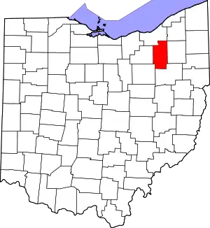 Map of Ohio highlighting Summit County | |
| Villages | ||
| Townships | ||
| CDPs | ||
| Unincorporated communities | ||
| Footnotes | ‡This populated place also has portions in an adjacent county or counties | |
| ||
| Authority control |
|---|