Northport, Maine
Northport is a town on Penobscot Bay in Waldo County, Maine, United States.[4] The population was 1,520 at the 2010 census. It is home to the Bayside Historic District (Northport, Maine), which includes over 100 Victorian seaside cottages, a marina, and the Cobe Estate.
Northport, Maine | |
|---|---|
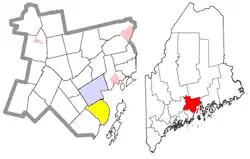 Location of Northport (in yellow) in Waldo County and the state of Maine | |
| Coordinates: 44°20′38″N 68°59′17″W | |
| Country | United States |
| State | Maine |
| County | Waldo |
| Area | |
| • Total | 34.99 sq mi (90.62 km2) |
| • Land | 23.78 sq mi (61.59 km2) |
| • Water | 11.21 sq mi (29.03 km2) |
| Elevation | 420 ft (128 m) |
| Population | |
| • Total | 1,520 |
| • Estimate (2012[3]) | 1,528 |
| • Density | 63.9/sq mi (24.7/km2) |
| Time zone | UTC-5 (Eastern (EST)) |
| • Summer (DST) | UTC-4 (EDT) |
| ZIP code | 04849 |
| Area code(s) | 207 |
| FIPS code | 23-52845 |
| GNIS feature ID | 0582636 |
Geography
According to the United States Census Bureau, the town has a total area of 34.99 square miles (90.62 km2), of which, 23.78 square miles (61.59 km2) of it is land and 11.21 square miles (29.03 km2) is water.[1] Principle bodies of water include: Pitcher Pond (370 acres),Knight Pond (95 acres) and Belfast Reservoir #1 (37 acres).
Northport is served by US Route 1 and Maine State Route 52. The town is bordered by Belfast on the north, Belmont on the west and Lincolnville on the south and Penobscot Bay on the east.
Demographics
| Historical population | |||
|---|---|---|---|
| Census | Pop. | %± | |
| 1800 | 482 | — | |
| 1810 | 780 | 61.8% | |
| 1820 | 939 | 20.4% | |
| 1830 | 1,083 | 15.3% | |
| 1840 | 1,207 | 11.4% | |
| 1850 | 1,260 | 4.4% | |
| 1860 | 1,178 | −6.5% | |
| 1870 | 902 | −23.4% | |
| 1880 | 872 | −3.3% | |
| 1890 | 691 | −20.8% | |
| 1900 | 545 | −21.1% | |
| 1910 | 518 | −5.0% | |
| 1920 | 466 | −10.0% | |
| 1930 | 413 | −11.4% | |
| 1940 | 485 | 17.4% | |
| 1950 | 574 | 18.4% | |
| 1960 | 658 | 14.6% | |
| 1970 | 755 | 14.7% | |
| 1980 | 958 | 26.9% | |
| 1990 | 1,201 | 25.4% | |
| 2000 | 1,331 | 10.8% | |
| 2010 | 1,520 | 14.2% | |
| 2014 (est.) | 1,545 | [5] | 1.6% |
| U.S. Decennial Census[6] | |||
2010 census
As of the census[2] of 2010, there were 1,520 people, 681 households, and 429 families living in the town. The population density was 63.9 inhabitants per square mile (24.7/km2). There were 1,162 housing units at an average density of 48.9 per square mile (18.9/km2). The racial makeup of the town was 98.1% White, 0.3% African American, 0.1% Native American, 0.3% Asian, 0.1% from other races, and 1.1% from two or more races. Hispanic or Latino of any race were 0.7% of the population.
There were 681 households, of which 25.1% had children under the age of 18 living with them, 50.7% were married couples living together, 7.6% had a female householder with no husband present, 4.7% had a male householder with no wife present, and 37.0% were non-families. 29.5% of all households were made up of individuals, and 13.3% had someone living alone who was 65 years of age or older. The average household size was 2.23 and the average family size was 2.74.
The median age in the town was 47.8 years. 19.6% of residents were under the age of 18; 5.7% were between the ages of 18 and 24; 20.4% were from 25 to 44; 34.3% were from 45 to 64; and 20.2% were 65 years of age or older. The gender makeup of the town was 48.7% male and 51.3% female.
2000 census
As of the census[7] of 2000, there were 1,331 people, 566 households, and 369 families living in the town. The population density was 56.2 people per square mile (21.7/km2). There were 943 housing units at an average density of 39.9 per square mile (15.4/km2). The racial makeup of the town was 98.05% White, 0.08% African American, 0.15% Native American, 0.60% Asian, 0.08% from other races, and 1.05% from two or more races. Hispanic or Latino of any race were 0.45% of the population.
There were 566 households, out of which 26.0% had children under the age of 18 living with them, 54.1% were married couples living together, 7.1% had a female householder with no husband present, and 34.8% were non-families. 27.4% of all households were made up of individuals, and 10.2% had someone living alone who was 65 years of age or older. The average household size was 2.35 and the average family size was 2.83.
In the town, the population was spread out, with 21.9% under the age of 18, 4.7% from 18 to 24, 26.7% from 25 to 44, 31.5% from 45 to 64, and 15.2% who were 65 years of age or older. The median age was 43 years. For every 100 females, there were 94.9 males. For every 100 females age 18 and over, there were 91.7 males.
The median income for a household in the town was $39,435, and the median income for a family was $45,000. Males had a median income of $31,193 versus $26,875 for females. The per capita income for the town was $21,438. About 6.0% of families and 11.5% of the population were below the poverty line, including 17.0% of those under age 18 and 6.9% of those age 65 or over.
References
- "US Gazetteer files 2010". United States Census Bureau. Retrieved 2012-12-16.
- "U.S. Census website". United States Census Bureau. Retrieved 2012-12-16.
- "Population Estimates". United States Census Bureau. Archived from the original on 2013-06-11. Retrieved 2013-07-06.
- DeLorme Mapping Company The Maine Atlas and Gazetteer (13th edition) (1988) ISBN 0-89933-035-5 map 15
- "Annual Estimates of the Resident Population for Incorporated Places: April 1, 2010 to July 1, 2014". Archived from the original on May 23, 2015. Retrieved June 4, 2015.
- "Census of Population and Housing". Census.gov. Retrieved June 4, 2015.
- "U.S. Census website". United States Census Bureau. Retrieved 2008-01-31.
External links
Municipalities and communities of Waldo County, Maine, United States | ||
|---|---|---|
| City |  Waldo County map | |
| Towns | ||
| CDPs | ||
| Other villages | ||
| ||