Northumberland Coalfield
The Northumberland Coalfield is a coalfield in north-east England. It is continuous with the Durham Coalfield to its south.[1] It extends from Shilbottle in the north to the boundary with County Durham along the River Tyne in the south, beyond which is the Durham Coalfield.[2]
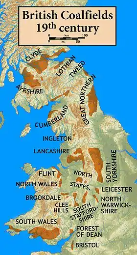
British Coalfields
The two contiguous coalfield areas were often referred to as the Durham and Northumberland Coalfield(s) or as the Great Northern Coalfield.[3]
Coal seams
The following coal seams are recorded from the Northumberland Coalfield. They are listed here in stratigraphic order with the youngest at the top and the oldest/deepest at the bottom.[4] Not all seams are named and not all occur at any one locality.
Pennine Coal Measures Group
Upper Coal Measures
- Killingworth
- West Moor
- Top Hebburn Fell
- Bottom Hebburn Fell
- Usworth
Middle Coal Measures
- Burradon
- Rowlington
- Top Ryhope Five-Quarter
- Bottom Ryhope Five-Quarter
- Ryhope Little
- Top Moorland
- Bottom Moorland
- Ashington
- High Main
- Metal
- Five-Quarter
- Bentinck
- Yard
- Top Bensham
- Bottom Bensham
- Top Durham Low Main
- Bottom Durham Low Main
- Northumberland Low Main
- Broomhill Main
- Top Plessey
- Plessey
- Bottom Plessey
Lower Coal Measures
- Beaumont
- Bottom Beaumont
- Top Tilley
- Tilley
- Bottom Tilley
- Top Busty
- Bottom Busty
- Three-Quarter
- Stobswood New
- Brockwell
- Victoria
- Stobswood
- Marshall Green
- Ganister Clay
- Gubeon
- Saltwick
References
- The NorthumberlandCoalfield, Coalmining History Research Centre, archived from the original on 2011-07-19, retrieved 2010-12-05
- British Geological Survey 2007 Bedrock geology: UK North 1:625,000 scale geological map, BGS, Keyworth, Notts
- "Archived copy". Archived from the original on 2012-02-29. Retrieved 2010-09-19.CS1 maint: archived copy as title (link)
- British Geological Survey 1:50,000 scale geological map sheet nos 6, 9, 10, 14 (England & Wales series) Alnwick, Rothbury, Newbiggin & Morpeth
This article is issued from Wikipedia. The text is licensed under Creative Commons - Attribution - Sharealike. Additional terms may apply for the media files.
