Novi Svet
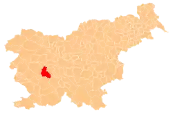
Novi Svet (pronounced [ˈnɔːʋi ˈsʋeːt], German: Neuwelt,[2] Italian: Mondonovo[3]) is a dispersed settlement in the hills west of Hotedršica in the Municipality of Logatec in the Inner Carniola region of Slovenia.[4]
Novi Svet | |
|---|---|
 Novi Svet Location in Slovenia | |
| Coordinates: 45°54′25.2″N 14°8′34.76″E | |
| Country | |
| Traditional region | Inner Carniola |
| Statistical region | Central Slovenia |
| Municipality | Logatec |
| Area | |
| • Total | 22.34 km2 (8.63 sq mi) |
| Elevation | 525.9 m (1,725.4 ft) |
| Population (2002) | |
| • Total | 94 |
| [1] | |
Geography
Novi Svet ranges across elevations between 500 and 600 meters (1,600 and 2,000 ft) southwest of the road from Kalce to Hotedršica, extending to the northeast slope of the Hrušica Plateau. It includes the hamlets of Gorenji Novi Svet (German: Oberneuwelt,[2] Italian: Mondonovo di Sopra) to the northwest and Dolenji Novi Svet (German: Unterneuwelt) to the southeast,[2] as well as the isolated Vrbanček farm. The area is mostly covered by needleleaf forest with many karst dells, sinkholes, and caves. The village has little arable land and sparse meadows, and so its residents have traditionally made a living from forestry.[5]
Name
The name Novi Svet literally means 'new area, new territory'. The name refers to the fact that the area was settled more recently than neighboring villages after wooded land was cleared.[6][7]
History
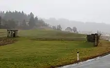
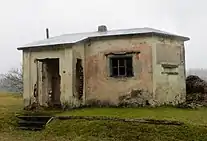
Some Slavic settlement may have already taken place in Novi Svet as early as the sixth century. Novi Svet was mentioned in historical sources in the 15th century in connection with iron working; the blast furnace that it supplied shut down in the 1589 due to a lack of ore. Settlers are said to have arrived in larger numbers in Novi Svet from Veharše in nearby Medvedje Brdo after the iron mining was abandoned there in the late 16th century, and also during French rule in the early 19th century in an effort to avoid military service.[8] Between the First and Second World Wars, the territory of Novi Svet lay west of the Rapallo border, in the Kingdom of Italy. The remains of the Italian border and customs posts along the road from Hotedršica to Godovič are located in the northeastern territory of Novi Svet.
References
- Statistical Office of the Republic of Slovenia
- Leksikon občin kraljestev in dežel zastopanih v državnem zboru, vol. 6: Kranjsko. Vienna: C. Kr. Dvorna in Državna Tiskarna. 1906. pp. 126–127.
- Yugoslavia, Official Standard Names Approved by the United States Board on Geographic Names. Washington, DC: Office of Geography. 1961. p. 263.
- Logatec municipal site
- Savnik, Roman (1968). Krajevni leksikon Slovenije, vol. 1. Ljubljana: Državna založba Slovenije. p. 183.
- Habič, Peter (1968). Kraški svet med Idrijco in Vipavo. Ljubljana: Slovenska akademija znanosti in umetnosti. p. 127.
- Trobič, Milan (2016). Še vedno na prepihu : pripovedi iz dežele med Logatcem in Črnim vrhom, Uncem in Rovtami. Ljubljana: Založba ZRC. p. 16.
- Bogataj, Franc (February 28, 1997). "Hotedršica". Logaške novice (2). p. 12. Retrieved February 3, 2020.
External links
 Media related to Novi Svet at Wikimedia Commons
- Novi Svet on Geopedia
| Settlements | Administrative centre: Logatec
|  | ||||
|---|---|---|---|---|---|---|
| Landmarks |
| |||||