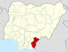
Obubra
Obubra is a Local Government Area (LGA) of Cross River State, Nigeria. Its headquarters are in the town of Obubra, which is home to the Ibrahim Babangida College of Agriculture.
Obubra | |
|---|---|
LGA and town | |
 Obubra Location in Nigeria | |
| Coordinates: 6°05′0″N 8°20′0″E | |
| Country | |
| State | Cross River State |
| Area there are several communities in Obubra, including Yala, Ochon, Iyamitet, Apiapum. There are also several towns and villages in Obubra LGA. | |
| • Total | 431 sq mi (1,115 km2) |
| Time zone | UTC+1 (WAT) |
The National Youth Service Corps, Cross River State Orientation Camp is situated in Obubra town.[1]
The word Obubra is derived from 'Ubibira, Ubira or Obira', the name of Obubra main village at the bank of the Cross river. Obubra however, was used to represent an administrative unit under the British colonial empire in the late 19th century. The exact history of the signed treaties of Community heads and the representatives of the British empire are in antiquity.
Obubra was created as a district in 1902. It covered areas bounded by Abakaliki and Ikom to the North, and Afikpo and Calabar to the South. This meant that its jurisdiction extended from parts of present-day Biase and Akamkpa local government areas through Abi, Yakurr and Etung to parts of Ikom and Ogoja local government areas.
Presently Obubra Local Government Area has eleven Council wards of Ababene, Ofat, Ofodua, Ovonum, Apiapum, Iyamoyong, Ochon, Obubra Urban, Ofumbongha/Yala, Osopong I and Osopong II.
Most of the communities emerged as settlements of intercommunal wars. The lines of friction which had existed from ancestral origin are heated up and the people divided by their political elites who disagree to agree on a common political leadership or a channel for socioeconomic development of Obubra Urban, wherein lies the headquarters, and then spread to all communities. Obubra has 98 villages some of which include; Apiapum, Iyamoyong, Ohana, Ochon, Isabang, Ovunom, Ofodua, Ofat, Ababene, Oderegha, Okorogbana, Onyedama, Ebo, and Iko, Ogurude, Ofonmana, Ogurokpon, Okimbongha, Ofonatam, Appiapumtet, Idoro and Ogamina.
It has an area of 1,115 km2 and a population of 172,444 at the 2006 census.
The postal code of the area is 551.[2]
References
- "LIST OF INSTITUTIONS FOR 2008 BATCH 'B' SERVICE YEAR". National Youth Services Corp. Archived from the original on 2011-07-24. Retrieved 2010-03-21.
- "Post Offices- with map of LGA". NIPOST. Archived from the original on 2012-11-26. Retrieved 2009-10-20.

