Ohanapecosh Glacier
The Ohanapecosh Glacier is small glacier located on Mount Rainier's southeastern flanks in Washington. It covers 0.6 square miles (1.6 km2) and contains 1.3 billion ft3 (37 million m3) of ice.[2] The glacier consists of several lobes of ice interconnected by thin snowfields. Most of the glacier lies at an elevation of 8,300 feet (2,500 m) to 7,400 feet (2,300 m), near the Whitman and the Fryingpan Glacier.[3] Since this ice lobe ends on a cliff, it contributes ice to the lower portions of the Ohanapecosh Glacier. The lower sections of this glacier end on cliffs and a small valley at about 6,100 ft (1,900 m) in elevation.[3] Meltwater from the glacier drains into the Ohanapecosh River and the Muddy Fork Cowlitz River, which merge downstream about four miles (6 km) outside of Mount Rainier National Park into the Cowlitz River.[2]
| Ohanapecosh Glacier | |
|---|---|
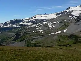 View SSW from Banshee Peak | |
| Type | Mountain glacier |
| Location | Mount Rainier, Pierce County, Washington, USA |
| Coordinates | 46°50′09″N 121°40′12″W[1] |
| Area | 0.6 square miles (1.6 km2), 1983[2] |
See also
References
- "Ohanapecosh Glacier". Geographic Names Information System. United States Geological Survey.
- "DESCRIPTION: Mount Rainier Glaciers and Glaciations - Mount Rainier Glacier Hazards and Glacial Outburst Floods". USGS. Retrieved 2007-11-19.
- "Ohanapecosh Glacier, USGS Mount Rainier East (WA) Topo Map". USGS Quad maps. TopoQuest.com. Retrieved 2008-05-17.