Ohio State Route 365
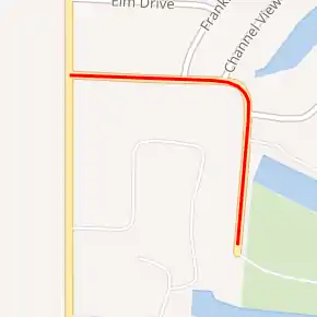
State Route 365 (SR 365) is a very short two-lane east–west state highway in western Ohio. It is currently the shortest signed state route in Ohio. Its western terminus is at a T-intersection with the SR 235/SR 366 concurrency one mile (1.6 km) north of the village of Lakeview. After running east and south for less than 980 feet (300 m), the highway arrives at its eastern terminus in Indian Lake State Park, serving a boat launch on the western shore of Indian Lake.
| ||||
|---|---|---|---|---|
SR 365 highlighted in red | ||||
| Route information | ||||
| Maintained by ODOT | ||||
| Length | 0.16 mi[1] (0.26 km) | |||
| Existed | 1934[2]–present | |||
| Major junctions | ||||
| West end | ||||
| East end | Indian Lake State Park near Lakeview | |||
| Location | ||||
| Counties | Logan | |||
| Highway system | ||||
| ||||

This spur route was created in 1934, and runs exclusively in Logan County. At a length of just 0.16 miles (260 m), SR 365 is one of the shortest state highways in Ohio.
Route description
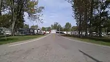
All of SR 365 exists within Stokes Township in northwestern Logan County. The short spur route is not a part of the National Highway System.[3] Around 230 vehicles use the route on average each day.[4] SR 365 is one of the shortest state routes in Ohio,[5] and there are no reassurance markers directly on SR 365. There is only one location marker on the route, at the beginning of the road.[6] All of SR 365 is paved in asphalt concrete.[7][8]
SR 365 begins at a T-intersection with the concurrency of SR 235 and SR 366 about one mile (1.6 km) north of Lakeview. The highway travels amidst a neighborhood of cottages as it heads east, with side streets radiating from it. After several jaunts, SR 365 proceeds south. The highway then arrives at its endpoint at a parking lot for a boat launch serving Indian Lake State Park on the west side of Indian Lake. A small driveway at SR 365's terminus leads back to SR 235/366.[9] Due to the lack of reassurance markers on SR 365, there are no markers marking the end of the route.[10]
History
The spur route was designated in 1934 along the short path that it currently runs; no significant changes have taken place to SR 365 since its inception.[11][2]
Major intersections
The entire route is in Stokes Township, Logan County.
| mi[1] | km | Destinations | Notes | ||
|---|---|---|---|---|---|
| 0.00 | 0.00 | ||||
| 0.16 | 0.26 | Indian Lake State Park | Boat launch parking lot | ||
| 1.000 mi = 1.609 km; 1.000 km = 0.621 mi | |||||
References
- "DESTAPE - Logan County" (PDF). Ohio Department of Transportation. June 24, 2015. Retrieved November 1, 2015.
- Ohio State Map (Map). Ohio Department of Highways. 1934. Retrieved 2013-08-09.
- National Highway System: Ohio (PDF) (Map). Federal Highway Administration. December 2003. Retrieved 2010-09-30.
- Staff. "Transportation Information Mapping System". Ohio Department of Transportation. Archived from the original on 2013-09-16. Retrieved 2013-08-09.
- Staff. "Straight Line Diagrams". Ohio Department of Transportation. Retrieved 2013-08-10.
- Google (2013-08-20). "Ohio State Route 365 - Western Terminus" (Map). Google Maps. Google. Retrieved 2013-08-20.
- Ohio Department of Transportation. "Technical Services Straight Line Diagrams – State Route 365" (PDF). Retrieved 2013-07-08.
- "Legend for Straight Line Diagrams" (PDF). Ohio Department of Transportation. Retrieved 2013-08-21.
- Google (November 1, 2015). "Overview Map of State Route 365" (Map). Google Maps. Google. Retrieved November 1, 2015.
- Google (2013-08-21). "Ohio State Route 365 - Eastern terminus" (Map). Google Maps. Google. Retrieved 2013-08-21.
- Ohio State Map (Map). Ohio Department of Highways. 1933. Retrieved 2013-08-09.
External links
 Media related to Ohio State Route 365 at Wikimedia Commons