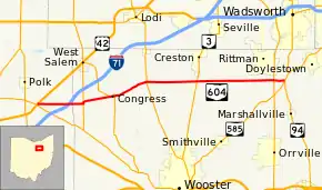
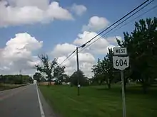
Ohio State Route 604
State Route 604 (SR 604) is an east–west state highway in north central Ohio. The western terminus of SR 604 is at a T-intersection with US 42 in Jackson Township approximately 5 miles (8.0 km) southwest of West Salem. Its eastern terminus is at the intersection that doubles as the southern split of the concurrency of SR 94 and SR 585 in Chippewa Township nearly 1.5 miles (2.4 km) southeast of Rittman.
| ||||
|---|---|---|---|---|
 | ||||
| Route information | ||||
| Maintained by ODOT | ||||
| Length | 24.13 mi[1] (38.83 km) | |||
| Existed | 1937–present | |||
| Major junctions | ||||
| West end | ||||
| East end | ||||
| Location | ||||
| Counties | Ashland, Wayne | |||
| Highway system | ||||
| ||||

Created in the late 1930s, this primarily rural route traverses the northeastern corner of Ashland County and the northern tier of Wayne County. State Route 604 passes through one incorporated community along its path, Congress, where it meets SR 539.
Route description
State Route 604 travels through the counties of Ashland and Wayne. No portion of this state highway is included within the National Highway System, a network of routes deemed most important to the country's economy, mobility and defense.[2]
History
SR 604 was first designated in 1937 along the path through northeastern Ashland County and northern Wayne County that it occupies to this day. The highway has not experienced any major changes since making its debut.[3][4]
Major intersections
| County | Location | mi[1] | km | Destinations | Notes |
|---|---|---|---|---|---|
| Ashland | Jackson Township | 0.00 | 0.00 | ||
| Wayne | Congress Township | 4.40 | 7.08 | Western end of SR 301 concurrency | |
| 4.52 | 7.27 | Eastern end of SR 301 concurrency | |||
| Congress | 7.20 | 11.59 | Western end of SR 539 concurrency | ||
| 7.56 | 12.17 | Eastern end of SR 539 concurrency | |||
| Canaan Township | 10.98 | 17.67 | |||
| 15.77 | 25.38 | ||||
| Milton–Chippewa township line | 23.05 | 37.10 | |||
| Chippewa Township | 24.13 | 38.83 | |||
1.000 mi = 1.609 km; 1.000 km = 0.621 mi
| |||||
References
- Ohio Department of Transportation. "Technical Services Straight Line Diagrams". Retrieved 2010-08-30.
- National Highway System: Ohio (PDF) (Map). Federal Highway Administration. December 2003. Retrieved 2010-08-20.
- Ohio State Map (Map). Ohio Department of Transportation. 1936.
- Ohio State Map (Map). Ohio Department of Transportation. 1937.