Okavango River
The Okavango River (formerly spelled Okovango or Okovanggo) is a river in southwest Africa. It is the fourth-longest river system in southern Africa, running southeastward for 1,600 km (990 mi). It begins at 1,300 m altitude in the sandy highlands of Angola, where it is known by the Portuguese name Rio Cubango. Farther south, it forms part of the border between Angola and Namibia, and then flows into Botswana. The Okavango does not have an outlet to the sea. Instead, it discharges into the Okavango Delta or Okavango Alluvial Fan, in an endorheic basin in the Kalahari Desert.
| Okavango | |
|---|---|
 Okavango in Kavango, Namibia | |
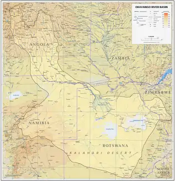 Okavango river basin map | |
| Location | |
| Countries | |
| Physical characteristics | |
| Mouth | |
• location | Moremi Game Reserve, Botswana |
| Length | 1,700 km (1,100 mi) |
| Basin size | 530,000 km2 (200,000 sq mi) |
| Discharge | |
| • average | 475 m3/s (16,800 cu ft/s) |
| • minimum | 350 m3/s (12,000 cu ft/s) |
| • maximum | 1,000 m3/s (35,000 cu ft/s) |
Flow
In Angola, the upper reaches of the Cuito (a tributary river to the Okavango) suffers clogging due to controlled burns of the vegetation, reducing water flow downstream as the accumulated water instead flows into the sand.[1]
Before it enters Botswana, the river drops 4 m in a series of rapids known as Popa Falls, visible when the river is low, as during the dry season.[2]
In the rainy season, an outflow to the Boteti River in turn seasonally discharges to the Makgadikgadi Pans, which features an expansive area of rainy-season wetland where tens of thousands of flamingos congregate each summer.[3] Part of the river's flow fills Lake Ngami. Noted for its wildlife, the Okavango area contains Botswana's Moremi Game Reserve.
Flood
.jpg.webp)
Every wet season, Angola receives three times more rainfall than Botswana, discharging a higher than usual flow into the Okavango, turning swathes of outlying desert into a huge wetland.
Although the summer rains fall in Angola in January, they take a whole month to travel the first 1,000 km of the Okavango River, and then they take a further four months to filter through the plants and numerous channels of the final 250 km of the delta. As a result, the flood is at its biggest sometime between June and August, during Botswana's dry winter months. The delta then swells to three times its permanent size, attracting animals from miles around and creating one of Africa's greatest concentrations of wildlife.
At its widest point in a big flood year, the seasonal swamp stretches to 150 km across from east to west; one of the factors that leads to the ever-changing nature of the delta is the flatness of the area. If one were to take a cross section of the delta at its widest point, one would find that the height variation from the mean over that 150 km is less than 2 m, which means that a minor sand deposition can cause major changes.[4]
In very wet years, a part of the river's flow may extend along the Magweggana River (actually a northeastern distributary of the Okavango Delta) and enter the Zambezi River, bypassing the Kalahari.
Sediment transport
The river carries annually 28,000 tonnes of suspended sediment and a similar amount of bedload to the terminal swamps.[5]
History
During colder periods in Earth's history, a part of the Kalahari was a massive lake, known as Lake Makgadikgadi. In this time, the Okavango would have been one of its largest tributaries.
.jpg.webp)
18°01′40″S 020°47′31″E
Water conflict
Both Namibia and Botswana experience drought, and as a result, concerns have been expressed about possible conflict over use of the river's water. Namibia has built a water canal, measuring about 300 km long, and has proposed a project to build a 250-km pipeline to divert water from the river into Namibia to help relieve the drought.[6][7]
Botswana, however, uses the Okavango Delta for both tourism income and a water source. The Department of Water Affairs in Botswana has submitted that 97% of the water in the river is lost through evaporation, so the country cannot afford to lose any extra water.
Namibia, in turn, has argued that it will only divert half of one percent of the river's flow, and that it is entitled to any water that flows through its country. To deal with such issues, in September 1994, Angola, Namibia, and Botswana signed an agreement to form the Permanent Okavango River Basin Water Commission, to provide advice to the three countries about the best ways to share the Okavango River's resources.[7][6]
References
- Society, National Geographic. "Okavango Wilderness Project". www.nationalgeographic.org. Into the Okavango. Archived from the original on 8 November 2020.
- Siyabona Africa Travel (Pty) Ltd, "Popa Falls | Okavango River | Botswana" webpage: TravelZA-PopaFalls
- C. Michael Hogan (2008) Makgadikgadi, The Megalithic Portal, ed. A. Burnham
- http://blog.africabespoke.com/okavango-delta-part-2/ Archived 2009-07-19 at the Wayback Machine Okavango River Flooding
- Hanibal Lemma, and colleagues (2019). "Bedload transport measurements in the Gilgel Abay River, Lake Tana Basin, Ethiopia". Journal of Hydrology. 577: 123968. Bibcode:2019JHyd..57723968L. doi:10.1016/j.jhydrol.2019.123968.
- Basedau, Matthias (2005-01-01). Resource Politics in Sub-Saharan Africa. GIGA-Hamburg. p. 294. ISBN 9783928049917.
- Varis, Olli; Tortajada, Cecilia; Biswas, Asit K. (2008-03-15). Management of Transboundary Rivers and Lakes. Springer Science & Business Media. p. 96. ISBN 9783540749288.