Old Fort Harrod State Park
Old Fort Harrod State Park is a park located in Harrodsburg, Kentucky in the United States. The park encompasses 15 acres (6.1 ha) and features a reconstruction of Fort Harrod, the first permanent American settlement in the state of Kentucky. The fort was named after James Harrod, who led an early party of settlers into Kentucky.[3]
| Old Fort Harrod State Park (Formerly Harrodstown) | |
|---|---|
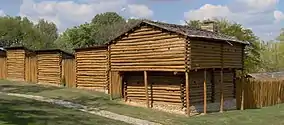 The reconstructed fort at the center of Old Fort Harrod State Park | |
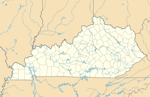 Location in Kentucky | |
| Location | Harrodsburg, Mercer, Kentucky, United States |
| Coordinates | 37°45′43″N 84°50′56″W[1] |
| Area | 15 acres (6.1 ha) |
| Elevation | 873 ft (266 m)[1] |
| Established | 1927[2] |
| Governing body | Kentucky Department of Parks |
| Website | Old Fort Harrod State Park |
Attractions
The reconstructed fort contains several log structures representing various aspects of military frontier life, including a militia blockhouse, a family blockhouse, several cabins demonstrating pioneer life, a blab school, the minister's cabin, and the leader's cabin. (The actual site of the original fort is under the current parking lot.)
The Mansion Museum is a Greek Revival home that contains American Civil War artifacts, a McIntosh gun collection, paintings, documents, music collections, Abraham Lincoln memorabilia and Native American artifacts.[2]
The park also features the cabin where Abraham Lincoln's parents, Thomas Lincoln and Nancy Hanks, were married.[4]
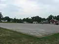 Parking lot for the fort, under which the actual fort site lies
History
1773-1774
The history of Old Fort Harrod can be traced back to they year 1773, where it is said that Captain James Harrod felled the first tree that signaled the beginning of human habitation in the Kentucky territory.[5] The fort itself was built in June of 1774 by James Harrod, Abraham Hite, Jacob and James Sandusky, and thirty other men including General James Ray and Captain William Pogue.[6] For the construction of the fort and Harrodsburg itself, one half-acre lot was laid out within the fort walls, and five acres of land were plotted outside the walls, one for each member of Harrod's crew. After the cabins were erected for each plot, they were distributed to each man in a lottery system.[5]
1780's - 1790's
In 1780, after the establishment of Harrodsburg, the Kentucky territory had been separated into three counties: Fayette, Jefferson, and Lincoln; Harrodsburg was then a part of Lincoln County. In 1785, the counties were further divided and Harrodsburg was made a part of Mercer County, where it is still a part of today.[5] Harrodsburg was the center of mercer county, and in the wake of the establishment of Mercer County, multiple county court meetings were held in the Harrodsburg courthouse between the dates of September 22, 1789 and April 27, 1790. Some of the most notable members of the court justices were Samuel McAfee and Samuel McDowell.[7]
Layout
The layout of the buildings within the fort remain the same, however, some of the landmarks, such as the springs are in different locations due to the forts relocation.
Fort Harrod itself spans an area of 264 square feet. The walls of the fort are composed of pickets measuring 14 feet tall and more than a foot in diameter; they are buried 4 feet in the ground, making the wall stand at about 10 feet tall all around. Gates are located on the North and West walls, spanning 10 feet wide.[8]
Inside the fort walls, there are blockhouses sitting at the Southwest and Southeast corners, where the upper stories extend 2 feet beyond the walls; they were built this way to allow for gunfire along the walls, where other gunmen may not have been able to reach from the stockades. Between these blockhouses sit seven story-and-a-half tall houses, measuring 20 feet by 20 feet,[9] with 10 feet of space between them. A single story tall cabin was built next to the east corner, which was used as a school. Two springs were located within the fort, one at the Northwest corner and one on the eastern side.[8] Currently, the spring near the Northeast wall is the only one within the fort walls. A blacksmith shop is located on the southern wall of the fort.[9]
References
- "Old Fort Harrod State Park". Geographic Names Information System. United States Geological Survey.
- "History". Old Fort Harrod State Park. Kentucky Department of Parks. Retrieved September 19, 2013.
- John Blankenbaker (April 6, 2011). "Page #026, Nr. 631". Germanna History Notes.
- Kleber, John E., ed. (1992). "Parks, State". The Kentucky Encyclopedia. Associate editors: Thomas D. Clark, Lowell H. Harrison, and James C. Klotter. Lexington, Kentucky: The University Press of Kentucky. ISBN 0-8131-1772-0.
- Daviess, Maria T. (1924). History of Mercer and Boyle Counties. Harrodsburg herald. p. 14.
- Daviess, Maria T. (1924). History of Mercer and Boyle Counties. Harrodsburg herald. pp. 5, 31, 33–34.
- STEPHENSON, W. W. (1910). "THE HISTORY OF HARRODSBURG (Continued)". Register of the Kentucky State Historical Society. 8 (22): 25–35. ISSN 2328-8183. JSTOR 23367173.
- Jillson, Willard Rouse (1930). "Harrod's Old Fort: 1791". Register of the Kentucky State Historical Society. 28 (82): 104–114. ISSN 2328-8183. JSTOR 23370070.
- Jillson, Willard Rouse (1930). "Harrod's Old Fort: 1791". Register of the Kentucky State Historical Society. 28 (82): 104–114. ISSN 2328-8183. JSTOR 23370070.
- "Replica of Fort Harrod, Harrodsburg, 1923-1928". Filson Club History Quarterly. 3 (1). October 1928. Retrieved 2011-11-11.
External links
| Wikimedia Commons has media related to Old Fort Harrod State Park. |
- Old Fort Harrod State Park Kentucky Department of Parks