Oltre Giuba
Oltre Giuba or Trans-Juba (Arabic: شرق جوبا الإيطالية) was an Italian colony in the territory of Jubaland in present-day southern Somalia. It lasted for one year, from 1924 until 1925, when it was absorbed into Italian Somaliland. Trans-juba is the former name of Jubaland, a federal member state of Somalia.[1]
Italian Trans-Juba Oltre Giuba Italiana | |||||||||
|---|---|---|---|---|---|---|---|---|---|
| 1924–1926 | |||||||||
.svg.png.webp) | |||||||||
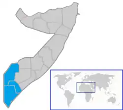 Trans-Juba shown on a map of present-day Somalia | |||||||||
| Status | Italian colony | ||||||||
| Capital | Kismayo | ||||||||
| Recognised national languages | Italian · Somali | ||||||||
| Religion | Islam · Roman Catholicism | ||||||||
| Historical era | Interwar period | ||||||||
• Established | 1924 | ||||||||
• Disestablished | 1926 | ||||||||
| Currency | Italian lira | ||||||||
| |||||||||
History
Jubaland
Italian Trans-Juba was established in 1924, after Britain ceded the northern portion of the Jubaland region to Italy as a reward for the Italians having joined the Allies in World War I.[2] The territory thereafter had a brief existence as Trans-Juba (Oltre Giuba) under governor Corrado Zoli (16 July 1924 – 31 December 1926).
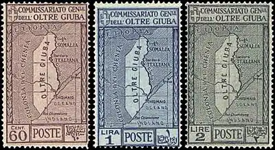
Italy issued its first postage stamps for the new colony on 29 July 1925, consisting of Italian stamps overprinted Oltre Giuba. Britain retained control of the southern half of the partitioned Jubaland territory, which was later called the Northern Frontier District (NFD).[3]
In 1925, a year after its formation, Trans-Juba was integrated into Italian Somaliland.[4]
The colony had a total area of 87,000 km² (33,000 sq mi), and in 1926, a population of 120,000 inhabitants. In the capital Kismayo (Chisimaio), there was a very little group of Italian settlers, mostly merchants. During this period, the city was the third largest in Somalia and served as a port of call for small military ships.
Bajuni Islands
The Bajuni Islands ("Isole Giuba") were part of British East Africa until World War I. They were later transferred to Italy in 1926.[5]
According to Wightwick Haywood, then a British official stationed in Kisimayo who visited the Bajuni Islands in 1913, the only inhabited islands in the chain were Tovai (i.e., Chovaye - the biggest island in the chain) and the nearby Tula (i.e. Chula). Each of these two islands were no more than three miles long and a mile wide. Maize, millet, sweet potatoes and coconuts were grown. The residents of the islands at the time, some of whom Haywood thought to be of Arab and/or Persian descent, built dhows, which the British official considered "excellent sea boats".[5] However, the islands were mainly inhabited by the eponymous Bajuni people.
References
- Cassanelli, Lee. "The opportunistic economics of the Kenya-Somali borderland in historical perspective." Borders and Borderlands as Resources in the Horn of Africa (2010): 133-150.
- Oliver, Roland Anthony (1976). History of East Africa, Volume 2. Clarendon Press. p. 7.
- Osman, Mohamed Amin AH (1993). Somalia, proposals for the future. SPM. pp. 1–10.
- http://www.dcstamps.com/?p=1296 Oltre Giuba (Trans-Juba), Italian Colony (1924 – 1926)
- Haywood, C. Wightwick (1935), "The Bajun Islands and Birikau", The Geographical Journal, 85 (1): 59–64, doi:10.2307/1787038, JSTOR 1787038
Bibliography
- Vittorio Bottego, Viaggi di scoperta nel cuore dell' Africa: il Giuba esplorato, sotta gli auspici della Società geografica italiana., E. Loescher & c.o, 1895
- Guida dell'Africa Orientale Italiana, Ed. Consociazione Turistica Italiana, Milano 1938, p. 585-596
- Tripodi, Paolo. The Colonial Legacy in Somalia. St. Martin's Press. New York, 1999.
Italian Somali | ||
|---|---|---|
| Main authorities | 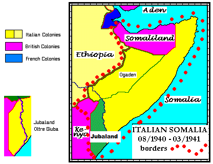 | |
| Governors |
| |
| General History | ||
| Infrastructures | ||
| Related articles |
| |
| Colonial troops | ||