Olyphant, Pennsylvania
Olyphant is a borough in Lackawanna County, Pennsylvania, United States. It is 6 miles (10 km) northeast of downtown Scranton, on the Lackawanna River in the heart of the anthracite region of the state. Its main source of employment was the mining and shipping of coal. Other industries of the past were the manufacturing of blasting powder, iron and steel goods, cigars, and silks. Olyphant experienced a severe downturn in the 1950s. There was once a thriving garment industry with numerous dress factories in the downtown area. There was also a slaughterhouse. Until recently, the biggest industry was the manufacture of compact discs (CD) and digital video discs (DVD). The population was 5,151 at the 2010 census.
Olyphant, Pennsylvania | |
|---|---|
 Borough hall | |
 Location of Olyphant in Lackawanna County, Pennsylvania | |
 Olyphant Location in Pennsylvania  Olyphant Location in the United States | |
| Coordinates: 41°27′45″N 75°35′44″W | |
| Country | United States |
| State | Pennsylvania |
| County | Lackawanna |
| Government | |
| • Mayor | John Sedlak Jr. |
| • Council members | James Baldan Jerry Tully Michael Abda Dina Harrington Robert Hudak David Krukovitz Elizabeth Frushon[1] |
| Area | |
| • Total | 5.50 sq mi (14.25 km2) |
| • Land | 5.44 sq mi (14.08 km2) |
| • Water | 0.06 sq mi (0.17 km2) |
| Elevation | 843 ft (257 m) |
| Population (2010) | |
| • Total | 5,151 |
| • Estimate (2019)[3] | 5,023 |
| • Density | 923.86/sq mi (356.70/km2) |
| Time zone | UTC-5 (EST) |
| • Summer (DST) | UTC-4 (EDT) |
| ZIP code | 18447-18448 |
| Area code(s) | 570 |
| FIPS code | 42-56792 |
| Website | olyphantborough |
Geography
Olyphant is located at 41°27′45″N 75°35′44″W (41.462630, -75.595617).[4]
According to the United States Census Bureau, the borough has a total area of 5.5 square miles (14 km2), of which, 5.4 square miles (14 km2) of it is land and 0.1 square miles (0.26 km2) of it (1.82%) is water.
Demographics
| Historical population | |||
|---|---|---|---|
| Census | Pop. | %± | |
| 1870 | 2,327 | — | |
| 1880 | 2,094 | −10.0% | |
| 1890 | 4,083 | 95.0% | |
| 1900 | 6,180 | 51.4% | |
| 1910 | 8,505 | 37.6% | |
| 1920 | 10,236 | 20.4% | |
| 1930 | 10,743 | 5.0% | |
| 1940 | 9,252 | −13.9% | |
| 1950 | 7,047 | −23.8% | |
| 1960 | 5,864 | −16.8% | |
| 1970 | 5,422 | −7.5% | |
| 1980 | 5,204 | −4.0% | |
| 1990 | 5,222 | 0.3% | |
| 2000 | 4,978 | −4.7% | |
| 2010 | 5,151 | 3.5% | |
| 2019 (est.) | 5,023 | [3] | −2.5% |
| Sources:[5][6][7] | |||
As of the census[8] of 2010, there were 5,151 people, 2,324 households, and 1,357 families residing in the borough. The population density was 953.9 people per square mile (368.3/km²). There were 2,521 housing units at an average density of 466.9 per square mile (182.4/km²). The racial makeup of the borough was 96.2% White, 1.6% African American, 0.1% Native American, 0.3% Asian, 0.7% from other races, and 1.1% from two or more races. Hispanic or Latino of any race were 3.4% of the population.
There were 2,324 households, out of which 23.8% had children under the age of 18 living with them, 41.9% were married couples living together, 11.6% had a female householder with no husband present, and 41.6% were non-families. 36.1% of all households were made up of individuals, and 17.2% had someone living alone who was 65 years of age or older. The average household size was 2.22 and the average family size was 2.90.
In the borough, the population was spread out, with 19.3% under the age of 18, 63.7% from 18 to 64, and 17% who were 65 years of age or older. The median age was 42.6 years.
The median income for a household in the borough was $32,721, and the median income for a family was $45,091. Males had a median income of $30,647 versus $24,825 for females. The per capita income for the borough was $17,049. About 7.4% of families and 11.3% of the population were below the poverty line, including 10.2% of those under age 18 and 24.2% of those age 65 or over.
Education
While the anthracite coal industry was thriving, there were numerous neighborhood schools: the Columbus School in the Smoketown section, the Washington School and the Roosevelt School in the Fern Hill section, the Lincoln School in the Grassy Island Heights section, as well as a three-room school in the Underwood Village and a one-room school in Marshwood. There was a Central School for elementary school students who lived downtown and in the Flats section. The annex of the Central School was Olyphant Senior High School. Olyphant Junior High School was in a separate building.
As the population declined, the neighborhood schools were closed and demolished. In 1969, the Olyphant, Dickson City, and Throop school districts consolidated to form the Mid Valley School District. The Olyphant Junior High School became the Mid-Valley Senior High School. The annex of the Olyphant Elementary School had elementary school grades as well as some overflow classes from the senior high school. On February 10, 1977, the Pennsylvania Department of Labor and Industry condemned the Olyphant Elementary School and the annex. The displaced elementary school students were moved to the Mid-Valley Junior High School in Dickson City. The displaced junior high school students and the senior high school students attended classes in the senior high school on split sessions. Eventually, new schools were built. Currently, the Mid-Valley School District has a single elementary school, and a single secondary school on Underwood Road in Throop.[9]
Up until the mid-1970s, each Catholic parish had a parochial school: St. Patrick’s, St. Michael’s, and Holy Ghost. Saints Cyril and Methodius Ukrainian Catholic School remained open longer, but it was eventually closed.
There are private Catholic schools in neighboring municipalities. The La Salle Academy Primary Campus in Dickson City is for students in Pre-Kindergarten through Grade 3; the Main Campus in Jessup is for students in Grades 4 through 8. High school students can attend Bishop O'Hara High School in Dunmore and Scranton Preparatory School in Scranton.
Notable people
- Nestor Chylak, Hall of Famer American League umpire[10]
- Patricia Crowley, actress, star of numerous films and the television series Please Don't Eat the Daisies[11]
- Mike Gazella, utility infielder for the 1926-28 New York Yankees[12]
 Holy Ghost Catholic church on Willow Street
 Saints Cyril & Methodius Ukrainian Greek Catholic Church
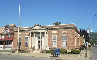 Former post office
References
- "Government". Olyphant Borough. Retrieved August 26, 2020.
- "2019 U.S. Gazetteer Files". United States Census Bureau. Retrieved July 28, 2020.
- "Population and Housing Unit Estimates". United States Census Bureau. May 24, 2020. Retrieved May 27, 2020.
- "US Gazetteer files: 2010, 2000, and 1990". United States Census Bureau. 2011-02-12. Retrieved 2011-04-23.
- "Census of Population and Housing". U.S. Census Bureau. Retrieved 11 December 2013.
- "U.S. Census website". United States Census Bureau. Retrieved 2008-01-31.
- "Incorporated Places and Minor Civil Divisions Datasets: Subcounty Resident Population Estimates: April 1, 2010 to July 1, 2012". Population Estimates. U.S. Census Bureau. Archived from the original on 11 June 2013. Retrieved 11 December 2013.
- "U.S. Census website". United States Census Bureau. Retrieved 2011-05-14.
- Klapatch, Joseph (May 2015). The old school : the Mid-Valley Elementary School in Olyphant, Pennsylvania (First ed.). Galloway, NJ: Joseph Peter Klapatch. ISBN 9781633187276.
External links
- Official website
- Pointon, Terri. Rootsweb.com. St. Patrick's Cemetery, Olyphant, Pennsylvania.
Municipalities and communities of Lackawanna County, Pennsylvania, United States | ||
|---|---|---|
| Cities | 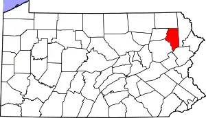 | |
| Boroughs | ||
| Townships | ||
| CDPs | ||
| Other unincorporated communities | ||
| ||
| Authority control |
|---|