Omala, Greece
Omala (Greek: Ομαλά) is a former community on the island of Kefalonia, Ionian Islands, Greece. Since the 2011 local government reform it is part of the municipality Kefalonia, of which it is a municipal unit.[2] It is located in the south-central part of the island. Its land area is 46.699 km²[3] and its population was 840 inhabitants at the 2011 census. The seat of the community was Valsamata, the only significant town (pop. 763). Its next largest settlements are Epanochori (33), and Michata (25).
Omala
Ομαλά | |
|---|---|
 Omala Location within the regional unit 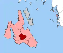 | |
| Coordinates: 38°10′N 20°36′E | |
| Country | Greece |
| Administrative region | Ionian Islands |
| Regional unit | Kefalonia |
| Municipality | Kefalonia |
| • Municipal unit | 46.699 km2 (18.031 sq mi) |
| Elevation | 400 m (1,300 ft) |
| Population (2011)[1] | |
| • Municipal unit | 840 |
| • Municipal unit density | 18/km2 (47/sq mi) |
| Time zone | UTC+2 (EET) |
| • Summer (DST) | UTC+3 (EEST) |
| Postal code | 281 00 |
| Area code(s) | 26710 |
| Vehicle registration | ΚΕ |
References
- "Απογραφή Πληθυσμού - Κατοικιών 2011. ΜΟΝΙΜΟΣ Πληθυσμός" (in Greek). Hellenic Statistical Authority.
- Kallikratis law Greece Ministry of Interior (in Greek)
- "Population & housing census 2001 (incl. area and average elevation)" (PDF) (in Greek). National Statistical Service of Greece.
This article is issued from Wikipedia. The text is licensed under Creative Commons - Attribution - Sharealike. Additional terms may apply for the media files.