Opolis, Kansas
Opolis is an unincorporated community in Crawford County, Kansas, United States.[1]
History
Opolis was originally called Stateline (from the community's proximity to the Missouri state line), and under the latter name was laid out in 1868.[2] Opolis is derived from the Greek polis, meaning "city".[3]
The first post office in Opolis was established in December, 1868. The post office was also called Stevenstown, Steventown, and Olopolis for some time in its early history.[4] It has a zip code of 66760. [5]
Geography
Opolis is located in the South Eastern corner of the state of Kansas close to the Missouri state line, approximately 133 miles (210 km) due south of Kansas City, KS at latitude 37.344 and longitude -94.621. It has an estimated population of 117 with 54 houses (based on a zipcode estimate from the year 2000) and covers 0.7743 square miles (2.01 km2) of land.[6] The elevation is 932 feet (284 m) above sea level. Opolis appears on the Asbury United States Geological Survey Map. It is in the Central time zone and observes Daylight Saving Time.,[7][8]
Education
The community is served by Pittsburg USD 250 public school district.
References
- U.S. Geological Survey Geographic Names Information System: Opolis, Kansas
- A Twentieth Century History and Biographical Record of Crawford County, Kansas. The Lewis Publishing Company. 1905. p. 33.
- "William G. Cutler's History of the State of Kansas". Archived from the original on 29 April 2003. Retrieved 7 August 2014.
- "Kansas Post Offices, 1828-1961, page 2 (archived)". Kansas Historical Society. Archived from the original on October 9, 2013. Retrieved 6 June 2014.
- http://www.usbeacon.com/Kansas/Opolis.html
- http://www.usbeacon.com/Kansas/Opolis.html
- "Opolis, Kansas community profile in the KS HomeTownLocator".
- "Google map of Opolis, KS".
Municipalities and communities of Crawford County, Kansas, United States | ||
|---|---|---|
| Cities | 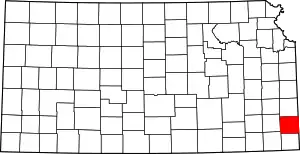 Map of Kansas highlighting Crawford County | |
| Unincorporated communities | ||
| Townships | ||
| Footnotes | †This populated place is designated a Census-Designated Place (CDP) by the United States Census Bureau, ‡This populated place also has portions in an adjacent county or counties. | |
| ||