Orlické Záhoří
Orlické Záhoří is a municipality and village in the Rychnov nad Kněžnou District in the Hradec Králové Region of the Czech Republic. It has about 200 inhabitants. It consists of several settlements in the Divoká Orlice valley between the Bystrzyckie Mountains and Orlické Mountains, along the border with Poland (which matches the flow of the Divoká Orlice river in this area).
Orlické Záhoří | |
|---|---|
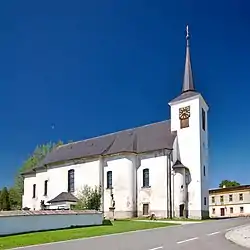 Church in Kunštát, a part of Orlické Záhoří | |
 Flag  Coat of arms | |
 Orlické Záhoří Location in the Czech Republic | |
| Coordinates: 50°17′4″N 16°27′8″E | |
| Country | |
| Region | Hradec Králové |
| District | Rychnov nad Kněžnou |
| First mentioned | 1571 |
| Government | |
| • Mayor | Vojtěch Špinler |
| Area | |
| • Total | 29.14 km2 (11.25 sq mi) |
| Elevation | 649 m (2,129 ft) |
| Population (2020-01-01[1]) | |
| • Total | 204 |
| • Density | 7.0/km2 (18/sq mi) |
| Time zone | UTC+1 (CET) |
| • Summer (DST) | UTC+2 (CEST) |
| Postal code | 517 64 |
| Website | www |
Administrative parts
Orlické Záhoří is made up of one administrative part, which was made by merger of settlements Bedřichovka, Černá Voda, Jadrná, Kunštát, Trčkov and Zelenka.
Name
The name may be approximately translated as "Orlice Transmountain Area."
History
It was established in 1951, while the constituting settlements trace back to 15–16th centuries.[2][3]
Gallery
 Former custom-house
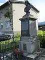 Joseph II, Holy Roman Emperor
References
- "Population of Municipalities – 1 January 2020". Czech Statistical Office. 2020-04-30.
- Orlické Záhoří profile, referring to the source: J. Šůla: Počátky osídlení horního toku Divoké Orlice, part 1. (sympozium Panorama 8, editorship SEN Dobré, 2000)
- Orlické Záhoří website (in Czech)
- "Miasta partnerskie (left menu)". bystrzycaklodzka.pl (in Polish). Gmina Bystrzyca Kłodzka. Retrieved 2020-08-26.
| Wikimedia Commons has media related to Orlické Záhoří. |
| Authority control |
|---|
This article is issued from Wikipedia. The text is licensed under Creative Commons - Attribution - Sharealike. Additional terms may apply for the media files.