Orrong Road
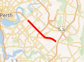
Orrong Road is a major arterial road servicing the metropolitan area of Perth, Western Australia as well as the south-eastern continuation of the Graham Farmer Freeway. It is a dual carriageway for its entire length, with multiple sets of traffic lights.
Orrong Road | |
|---|---|
| |
| General information | |
| Type | Road |
| Length | 8.1 km (5.0 mi)[1] |
| Opened | 1937[2] |
| Route number(s) | |
| Major junctions | |
| North-West end |
|
| |
| South-East end |
|
| Location(s) | |
| Major suburbs | Lathlain, Rivervale, Carlisle, Kewdale |
In addition to servicing the southeastern suburbs of Perth, the road provides a vital connection from the Perth CBD to Perth Airport, the Kewdale Freight Terminal and the Darling Scarp. It is designated H27 (Rivervale–Wattle Grove Link) in Main Roads' internal designation along with Welshpool Road East west of Tonkin Highway.[3]
Route description
The entire length of Orrong Road is a four lane dual-carriageway, similar to other major roads in the area such as Albany Highway, Welshpool Road and Abernethy Road. Unlike those roads however, the carriageways of Orrong Road are separated by a wide tree-lined central median, giving the road more of a boulevard appearance.
The western terminus of Orrong Road is located just to the southeast of the parclo interchange between Graham Farmer Freeway and Great Eastern Highway where the road transitions from a freeway to an at-grade dual carriageway. The road continues in a south-easterly direction forming the boundary between the Town of Victoria Park's Lathlain and the City of Belmont's Rivervale. The first traffic light intersection is encountered at Francisco Street. At Roberts Road the southern suburb boundary changes to Carlisle, with the northern suburb swapping to Kewdale just south of the signalised intersection with Archer Street (at the Sydenham Street cul-de-sac).
The next signalised intersection, with Wright Street, connects Orrong Road to Belmont Forum. The final set of lights prior to Leach Highway is found at the intersection with Oats Street. At Briggs Street the southern suburb boundary changes to the City of Canning's Welshpool with the road now marking the northern limit of the Welshpool industrial area
The road then intersects with Leach Highway at a diamond interchange with Leach Highway free-flowing over Orrong Road, after which the northern side also transitions from a residential to an industrial area. The next signalised intersection with Division and Bell Street sees the road fully enter Welshpool. Two more sets of lights are encountered at Pilbara Street and Kewdale Road. After Kewdale Road the road curves to the east and runs parallel with Welshpool Road 300–400 metres (980–1,310 ft) to the south. The two roads eventually connect to each other via a signalised intersection with McDowell Street as a proxy for Welshpool Road.
Orrong Road's eastern terminus is at the diamond interchange with Roe Highway. As with Leach Highway, Roe Highway is also free-flowing over Orrong Road, which continues as Welshpool Road East from this point.
History
Orrong Road was gazetted in 1937 from sections of roads at the time that were originally known as Hawkstone Street, Prospect Road, Burswood Avenue and Wickalls Avenue. The road was named after Orrong Road in Melbourne, itself an important road in Melbourne's inner south eastern suburbs[4]
Since gazetting Orrong Road has underwent major changes, starting with conversion to dual carriageway in the latter half of the 20th Century. In 1997 the intersection with Great Eastern Highway was converted to an interchange in preparation for the connection to Graham Farmer Freeway. In 2002, before Roe Highway's extension, Orrong Road would terminate at Welshpool Road in the form of a T-junction. Orrong Road was extended to meet Roe Highway in the form of a diamond interchange and now continues as Welshpool Road East. In 2007 the Leach Highway intersection was converted to an interchange.
Junctions
| LGA | Location[1] | km | mi | Destinations | Notes |
|---|---|---|---|---|---|
| Victoria Park–Belmont boundary | Burswood–Lathlain | 0 | 0.0 | Northern terminus of Orrong Road starts just south of the interchange; Modified diamond interchange: additional north-westbound looped entrance ramp. Orrong Road continues as Graham Farmer Freeway northbound. | |
| Lathlain-Rivervale boundary | 0.6 | 0.37 | Francisco Street northeast – Belmont Francisco Place southwest | Traffic light intersection | |
| Lathlain-Rivervale-Carlisle tripoint | 1.2 | 0.75 | Roberts Road – Victoria Park | ||
| Rivervale-Carlisle boundary | 1.5 | 0.93 | Alexander Road | ||
| 1.7 | 1.1 | Archer Street – Victoria Park | Traffic light intersection | ||
| Carlisle-Kewdale boundary | 2.1 | 1.3 | Wright Street northeast – Cloverdale Galaxy Way southwest | Traffic light intersection with full movements between Orrong Road and Wright Street only. Galaxy Way unsignalised, northbound left in only | |
| 2.7 | 1.7 | Oats Street – East Victoria Park, Bentley, Cloverdale | Traffic light intersection | ||
| Victoria Park–Belmont-Canning tripoint | Carlisle-Kewdale-Welshpool tripoint | 3.2 | 2.0 | Briggs Street | |
| Belmont-Canning boundary | Kewdale-Welshpool boundary | 3.8 | 2.4 | Diamond interchange (Leach Highway free flowing) | |
| 4.1 | 2.5 | Bell Street northeast Division Street southwest | Traffic light intersection | ||
| Canning | Welshpool | 4.7 | 2.9 | Pilbara Street | Traffic light intersection |
| 5.1 | 3.2 | Traffic light intersection | |||
| 6.1 | 3.8 | Kurnall Road | |||
| 7 | 4.3 | McDowell Street – East Victoria Park, Beckenham | Traffic light intersection, main connection to Welshpool Road. | ||
| Welshpool-East Cannington boundary | 7.7 | 4.8 | Felspar Street – East Victoria Park, East Cannington, Beckenham | ||
| 8.1 | 5.0 | Southern terminus of Orrong Road, continues as Welshpool Road East southeast-bound; Diamond interchange (Roe Highway free-flowing). | |||
| 1.000 mi = 1.609 km; 1.000 km = 0.621 mi | |||||
References
- Google (9 November 2019). "Orrong Road" (Map). Google Maps. Google. Retrieved 9 November 2019.
- "CITY OF BELMONT - List of Names of Streets/Roads, Suburbs, Parks, Perth Airport Roads and Schools" (PDF). Retrieved 9 November 2019.
- Main Roads Western Australia (28 February 2011). "Metropolitan Network" (Map). Intergrated Service Arrangement. 1:500,000. Government of Western Australia. Archived from the original (PDF) on 3 August 2013. Retrieved 9 November 2019.
- "CITY OF BELMONT - List of Names of Streets/Roads, Suburbs, Parks, Perth Airport Roads and Schools" (PDF). Retrieved 9 November 2019..
| National Highways | |||
|---|---|---|---|
| National Routes | |||
| State Routes | |||
| Tourist Drives | |||
