Ostrý Grúň
Ostrý Grúň (Hungarian: Élesmart) is a village and municipality in the Žarnovica District, Banská Bystrica Region in Slovakia.
Ostrý Grúň | |
|---|---|
Village | |
 | |
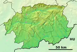 Ostrý Grúň Location of Ostrý Grúň in the Banská Bystrica Region  Ostrý Grúň Ostrý Grúň (Slovakia) | |
| Coordinates: 48°33′49″N 18°39′47″E | |
| Country | Slovakia |
| Region | Banská Bystrica |
| District | Žarnovica |
| Area | |
| • Total | 16.71 km2 (6.45 sq mi) |
| Elevation | 450 m (1,480 ft) |
| Population (2019-12-31) | |
| • Total | 543 |
| • Density | 32/km2 (84/sq mi) |
| Postal code | 966 77 |
| Area code(s) | +421-45 |
| Car plate | ZC |
| Website | www |
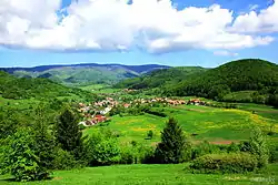
View of Ostrý Grúň in Zuberska valley
History
The village was massacred and burned down in January 1945 by the Nazi anti-partisan unit Edelweiss, after the suppression of the Slovak National Uprising.[1]
Geography
The municipality lies at an altitude of 450 metres, covering an area of 16.71 km².[2] It is part of the Vtáčnik mountain range, within the Slovak Central Mountains.
Demographics
The municipality has a population of 543, as of December 2019.[3]
In 2011, 86% of the population identified as Slovak. The religious makeup was 75.6% Roman Catholic and 4.2% unaffiliated.[4]
International relations
References
- Žišková-Moroňová, K. a kolektív: Dejiny Slovenského národného povstania 1944 – 5. zväzok. Bratislava, Nakladateľstvo Pravda 1985, s. 367 – 368 (In Slovak)
- http://www.skgeodesy.sk/sk/ugkk/kataster-nehnutelnosti/registre-obnovenej-evidencie-pozemkov/
- http://datacube.statistics.sk/#!/view/sk/VBD_DEM/om7101rr/v_om7101rr_00_00_00_sk
- http://www.sodbtn.sk/obce/obec_stat_narodnost.php?kod_obce=517119
- "Twinnings" (PDF). Central Union of Municipalities & Communities of Greece. Archived from the original (PDF) on 2018-10-04. Retrieved 2013-08-25.
This article is issued from Wikipedia. The text is licensed under Creative Commons - Attribution - Sharealike. Additional terms may apply for the media files.