Osztopán
Osztopán (Croatian: Stupan) is a village in Somogy county, Hungary.
Osztopán
Stupan (in Croatian) | |
|---|---|
Village | |
 Tallián Mansion in Osztopán | |
 Coat of arms | |
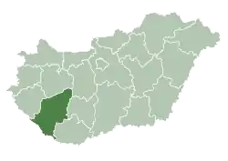
 Osztopán Location of Osztopán | |
| Coordinates: 46.52032°N 17.67068°E | |
| Country | |
| Region | Southern Transdanubia |
| County | Somogy |
| District | Kaposvár |
| RC Diocese | Kaposvár |
| Area | |
| • Total | 22.83 km2 (8.81 sq mi) |
| Population (2017) | |
| • Total | 824[1] |
| Demonym(s) | osztopáni |
| Time zone | UTC+1 (CET) |
| • Summer (DST) | UTC+2 (CEST) |
| Postal code | 7444 |
| Area code(s) | (+36) 82 |
| NUTS 3 code | HU232 |
| MP | József Attila Móring (KDNP) |
| Website | Osztopán Online |
Etymology
The name comes from the Slavic Stupan[2][3] derived from the Proto-Slavic stem stǫp- with several meanings and possible etymologies (i.e. stǫpa/stupa: trapping pit,[2] see also the etymology of Stupava).
History
According to László Szita the settlement was completely Hungarian in the 18th century.[4]
Highway bridge bombed by 97th BG on 30 June 1944 when primary target Blechammer oil refinery was overcast.
Culture
The Hungarian folk song Osztopáni malomárok was colledcted in Osztopán in 1949 by Ferenc Gönczi.
References
- Osztopán, KSH
- Stanislav, Ján (2004). Slovenský juh v stredoveku II (in Slovak). Slovenské literárne centrum. p. 325. ISBN 80-88878-89-6.
- Kiss, Lajos (1978). Földrajzi nevek etimológiai szótára (in Hungarian). Budapest: Akadémiai. p. 488.
- László Szita : Somogy megyei nemzetiségek településtörténete a XVIII-XIX. században - Somogyi Almanach 52. (Kaposvár, 1993)
External links
This article is issued from Wikipedia. The text is licensed under Creative Commons - Attribution - Sharealike. Additional terms may apply for the media files.