Otakou
Otakou (Māori: Ōtākou [ɔ:ˈta:kou]) is a settlement within the boundaries of the city of Dunedin, New Zealand. It is located 25 kilometres from the city centre at the eastern end of Otago Peninsula, close to the entrance of Otago Harbour.[1][2][3] Though a small fishing village, Otakou is important in the history of Otago for several reasons. The settlement is the modern centre and traditional home of the Ōtākou rūnanga (assembly) of Ngāi Tahu. In 1946 Otakou Fisheries was founded in the township; this was later to become a major part of the Otago fishing industry.[4][5]
Otakou
| |
|---|---|
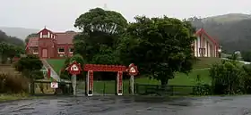 Ōtākou Marae | |
| Country | New Zealand |
| Region | Otago |
| Territorial authority | Dunedin City Council |
| Time zone | UTC+12 (NZST) |
| • Summer (DST) | UTC+13 (NZDT) |
| Local iwi | Ngāi Tahu |
History
The name Ōtākou is thought to come from Māori words meaning either "single village" or "place of red earth".[6] Prior to the arrival of European settlers, the place was a prominent Māori settlement, and it is still the site of Otago's most important marae (meeting ground). By the early 19th century, the three Māori iwi of Ngāi Tahu, Kāti Māmoe and Waitaha had blended into a single tribal entity. The Treaty of Waitangi was signed nearby in 1840 on the H.M.S Herald by two important chiefs, who were descended from all three tribes.[7][8]
Prior to the standardisation of Māori spelling in the 1840s, the name was written as "Otago", reflecting its pronunciation in a local southern Māori dialect. This prestandardised form was adopted by European settlers as the name for the surrounding area, the Otago region, and it is commonly mistaken as a European corruption of Ōtākou.[9] The name originally referred to the channel off Wellers Rock but was transferred to the lower harbour as a whole, the port, the nearby Māori settlements and the Weller brothers' whaling establishment, one of the region's oldest European settlements, which had been founded in 1831. The old Māori names for the Māori settlements were Te Ruatitiko, Tahakopa, Omate and Ohinetu.
In December 1817 the Sophia, a Hobart sealing ship captained by James Kelly, anchored in the waters of the harbour near Otakou. A small group of men, including Captain Kelly, took a rowing boat around Heyward Point to visit Whareakeake, then the site of a Māori kāinga (village), where one of the men, William Tucker, had a house and a business selling hei-tiki. For reasons that remain speculative, the encounter turned violent and three of Kelly's men, including Tucker, were killed. The survivors rowed back to the Sophia but, according to Kelly's account of the event, found her boarded by Māori from Otakou and retook her in a bloody fight.[10][11] Historians caution that Kelly's account, made to justify the actions he took, exaggerates the danger he and his men were in.[12][13] Kelly destroyed multiple canoes and set fire to "the beautiful city of Otago",[14] which was almost certainly Otakou,[15] although the kāinga at Whareakeake was also burned and abandoned around this time, which some historians believe to have been Kelly's doing.[13] This incident is treated as an episode in the ongoing state of lawless conflict known as the Sealers' War.
Present use
Otakou remains an important centre of Ngāi Tahu life, as the location of Ōtākou Marae. It is a marae of Ngāi Tahu and the branch of Te Rūnanga o Ōtākou, and includes the Tamatea wharenui (meeting house).[16][17]
Otakou is located close to Taiaroa Head, the site of an albatross colony and other wildlife such as seals and penguins. Local Māori still call Taiaroa Head by its original name, Pukekura, which was also the name of the pā (fortification) established there around 1750 and still occupied by Māori in the 1840s, before the land was taken by the Government under the Public Works Act for building the lighthouse and the fortifications used during the Russian Scare of the 1880s.[1][2][3]
References
- Dann, C; Peat, N (1989). Dunedin, North and South Otago. Wellington, NZ: GP Books. ISBN 0-477-01438-0.
- Entwisle, Peter (1998). Behold the Moon: the European Occupation of the Dunedin District 1770-1848. Dunedin, NZ: Port Daniel Press. ISBN 0-473-05591-0.
- Goodall, M; Griffiths, G (1980). Māori Dunedin. Dunedin, NZ: Otago Heritage Books.
- Ellison, Craig. "Ellison, Raniera". Dictionary of New Zealand Biography. New Zealand Ministry for Culture and Heritage Te Manatu Taonga. Retrieved 26 November 2018.
- "Ngai Tahu plays the long game". Otago Daily Times Online News. 6 November 2013. Retrieved 26 November 2018.
- "1000 Māori place names". New Zealand Ministry for Culture and Heritage. 6 August 2019.
- "About Us". Ōtākou Runaka. Retrieved 2020-02-05.
- "Herald Bunbury treaty copy | NZHistory, New Zealand history online". nzhistory.govt.nz. Retrieved 2020-02-05.
- McKinnon, Malcolm (2012). Otago region - The Otago settlement.
- McNab, Robert (1906). "The Sophia Massacre, 1817". Murihiku: A History of the South Island of New Zealand and the Islands Adjacent and Lying to the South, from 1642 to 1835. pp. 225–230.
- Hamilton, A (1895). "On an Account of a Massacre at the Entrance of Dunedin Harbour in the Year - 1817". Transactions and Proceedings of the Royal Society of New Zealand. 28: 141–147.
- McLintock, A. H. (1949). The History of Otago. Otago Centennial Historical Publications. pp. 86–87.
- Skinner, H. D. (1959). "Murdering Beach collecting and excavating. The first phase 1850–1950". Journal of the Polynesian Society. 68 (3): 219–238. Retrieved 8 March 2020.
- Anderson, Atholl (1998). The Welcome of Strangers: An ethnohistory of southern Māori AD 1650–1850. University of Otago Press in association with Dunedin City Council. p. 71. ISBN 978-1-877133-41-1.
- Hamel, Jill (2001). The Archaeology of Otago (PDF). Department of Conservation. pp. 76–77. ISBN 0-478-22016-2.
- "Te Kāhui Māngai directory". tkm.govt.nz. Te Puni Kōkiri.
- "Māori Maps". maorimaps.com. Te Potiki National Trust.
Further reading
- Anderson, Atholl (1983). When All the Moa-Ovens Grew Cold: Nine Centuries Of Changing Fortune for the Southern Maori. Dunedin, NZ: Otago Heritage Books.
- Entwisle, Peter (2010). Behold the Moon, the European Occupation of the Dunedin District 1770-1848 (Paperback). Dunedin, NZ: Port Daniel Press. ISBN 978-0-473-17534-4.
- Knight, Hardwicke (1978). Otago Peninsula: A Local History. Broad Bay, NZ: Hardwicke Knight.
- West, Jonathan (2017). The Face of Nature: An Environmental History of Otago Peninsula (Paperback). Dunedin, NZ: Otago University Press. ISBN 978-1-927322-38-3.