Ottadalen
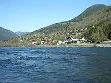
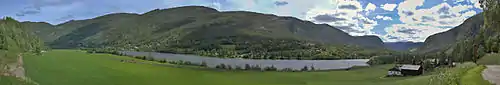
The Otta Valley[1][2][3] (Norwegian: Ottadalen) is a valley in the municipalities of Skjåk, Lom, Vågå, and Sel in the county of Innlandet, Norway.
The Otta Valley is one of the lateral valleys of the Gudbrand Valley. Others include Billingsdal, Gausdal, Heidal, and Vinstra. It lies on the northern edge of Jotunheimen National Park. Historically, the Otta Valley has been widely used as artery between western and eastern Norway through the Breidalen in Skjåk to Stryn, Breidalskrysset to Stranda, the Jostedalsbreen glacier to Jostedalen and Luster, and Sognefjellet to Sogn. There is also a road from Vågå, through Jotunheimen to Fagernes.
The Otta River flows through the Otta Valley. The Otta River begins in the municipality of Skjåk and flows into lake Vågåvatnet. Exiting Vågåvatnet at Vågåmo, it continues its journey through the Otta Valley, leaving the municipality of Vågå to meet the Gudbrandsdalslågen at the town of Otta in the municipality of Sel.
Reinheimen National Park, which consists of much of the Tafjordfjella mountain range, includes the reindeer habitat in the northern part of the Otta Valley.[4]
References
- Peppoloni, Silvia, & G Di Capua. 2015. Geoethics: the Role and Responsibility of Geoscientists. London: The Geological Society, p. 8.
- Doré, A. g. 2002. Exhumation of the North Atlantic Margin: Timing, Mechanisms and Implications for Petroleum Exploration. London: The Geological Society, p. 105.
- Lemmer, Gerhard, Elke Frey, & Helga Rahe. 2001. Norway. Basingstoke, UK: GeoCenter, p. 148.
- Reinheimen Area Mountains Guide (NorWaves.com)
