Ouderkerk
![]() Ouderkerk (population: data missing
in 2019) is a former municipality in the western Netherlands, in the province of South Holland. Since 2015 it has been a part of the municipality of Krimpenerwaard.
Ouderkerk (population: data missing
in 2019) is a former municipality in the western Netherlands, in the province of South Holland. Since 2015 it has been a part of the municipality of Krimpenerwaard.
Ouderkerk | |
|---|---|
Former municipality | |
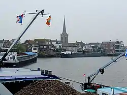 View over Ouderkerk aan den IJssel | |
_vlag.svg.png.webp) Flag  Coat of arms | |
.svg.png.webp) Location in South Holland | |
| Coordinates: 51°56′N 4°38′E | |
| Country | Netherlands |
| Province | South Holland |
| Municipality | Krimpenerwaard |
| Established | 1 January 1985 |
| Area | |
| • Total | 28.57 km2 (11.03 sq mi) |
| • Land | 27.07 km2 (10.45 sq mi) |
| • Water | 1.50 km2 (0.58 sq mi) |
| Elevation | 0 m (0 ft) |
| Population (January 2019)[3] | |
| • Total | data missing |
| Demonym(s) | Ouderkerker |
| Time zone | UTC+1 (CET) |
| • Summer (DST) | UTC+2 (CEST) |
| Postcode | 2830–2831, 2935 |
| Area code | 0180, 0182 |
| Website | www |
The former municipality covered an area of 28.57 km2 (11.03 sq mi) of which 1.50 km2 (0.58 sq mi) was water. It was formed on 1 January 1985, after a municipal reorganization.
The former municipality of Ouderkerk consisted of the population centres Gouderak, Lageweg, Ouderkerk aan den IJssel, and IJssellaan, all situated along the Hollandse IJssel river.
Topography
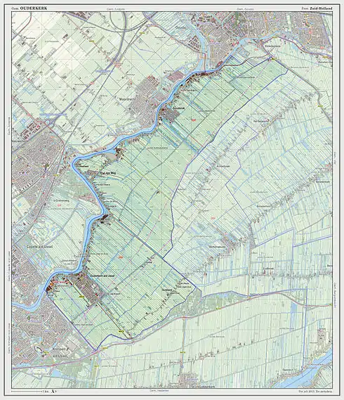
Dutch Topographic map of the former municipality of Ouderkerk, 2013.
References
- "Kerncijfers wijken en buurten 2020" [Key figures for neighbourhoods 2020]. StatLine (in Dutch). CBS. 24 July 2020. Retrieved 19 September 2020.
- "Postcodetool for 2935AB". Actueel Hoogtebestand Nederland (in Dutch). Het Waterschapshuis. Retrieved 17 August 2013.
- "Bevolkingsontwikkeling; regio per maand" [Population growth; regions per month]. CBS Statline (in Dutch). CBS. 1 January 2019. Retrieved 1 January 2019.
External links
Places adjacent to Ouderkerk | |
|---|---|
This article is issued from Wikipedia. The text is licensed under Creative Commons - Attribution - Sharealike. Additional terms may apply for the media files.
