Outline of Meghalaya
The following outline is provided as an overview of and topical guide to Meghalaya:
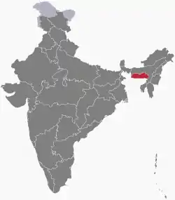
Location of Meghalaya
Meghalaya – state in north-east India. The name means "the abode of clouds" in Sanskrit. The state is the wettest region of India, recording an average of 12,000 mm (470 in) of rains a year.[6] About 70% of the state is forested.[8] The Meghalaya subtropical forests ecoregion encompasses the state; its mountain forests are distinct from the lowland tropical forests to the north and south. The forests are notable for their biodiversity of mammals, birds, and plants.
General reference
Names
- Common English name: Meghalaya
- Official English name(s): Meghalaya
- Nickname(s):
- Adjectival(s): Meghalayan
- Demonym(s): Meghalayans
Rankings (amongst India's states)
- by population: 23rd
- by area (2011 census): 23rd
- by crime rate (2015): 22nd
- by gross domestic product (GDP) (2014): 24th
- by Human Development Index (HDI):
- by life expectancy at birth:
- by literacy rate:
Geography of Meghalaya
- Meghalaya is: an Indian state, and one of the Seven Sister States
- Population of Meghalaya: 3,211,000 (2014)
- Area of Meghalaya: 22,429 km2 (8,660 sq mi)
- Atlas of Meghalaya
Location of Meghalaya
- Meghalaya is situated within the following regions:
- Time zone: Indian Standard Time (UTC+05:30)
Places adjacent to Outline of Meghalaya | ||||||||||
|---|---|---|---|---|---|---|---|---|---|---|
| ||||||||||
Districts of Meghalaya
Municipalities of Meghalaya
- Cities of Meghalaya
- Capital of Meghalaya: Capital of Meghalaya
Demography of Meghalaya
Government and politics of Meghalaya
- Form of government: Indian state government (parliamentary system of representative democracy)
- Capital of Meghalaya: Capital of Meghalaya
- Elections in Meghalaya
Union government in Meghalaya
Branches of the government of Meghalaya
Executive branch of the government of Meghalaya
- Head of state: Governor of Meghalaya,
- Head of government: Chief Minister of Meghalaya,
Legislative branch of the government of Meghalaya
Judicial branch of the government of Meghalaya
- High Court of Meghalaya
- Chief Justice of Meghalaya
Law and order in Meghalaya
- Law enforcement in Meghalaya
History of Meghalaya
Culture of Meghalaya
- Architecture of Meghalaya
- Cuisine of Meghalaya
- Monuments in Meghalaya
- World Heritage Sites in Meghalaya
Art in Meghalaya
Sports in Meghalaya
Sports in Meghalaya
- Cricket in Meghalaya
- Football in Meghalaya
Symbols of Meghalaya
- State animal:
- State bird:
- State flower:
- State seal: Seal of Meghalaya
- State tree:
Economy and infrastructure of Meghalaya
Health in Meghalaya
Health in Meghalaya
See also
References
- "Definition of Meghalaya in English from the Oxford Dictionary". Oxford Dictionaries. Retrieved April 2015. Check date values in:
|accessdate=(help) - Define Meghalaya at Dictionary.com
External links
- Official website
- Tourism of Meghalaya (Official)
- Outline of Meghalaya at Curlie
This article is issued from Wikipedia. The text is licensed under Creative Commons - Attribution - Sharealike. Additional terms may apply for the media files.