Oxapampa Province
The Oxapampa Province (Spanish: Provincia de Oxapampa) is the largest of three provinces that make up the Pasco Region in Peru.[3] The capital of the Oxapampa province is the city of Oxapampa. The province is located on the eastern slopes of the Andes reaching down to the lowlands of the Amazon Basin. The high point of the province is approximately 5,300 metres (17,400 ft) in elevation near the summit of Huaguruncho mountain in the Huancabamba District and the low point is approximately 200 metres (660 ft) on the Pachitea River in the Constitución District.[4]
Oxapampa | |
|---|---|
 Flag  Coat of arms | |
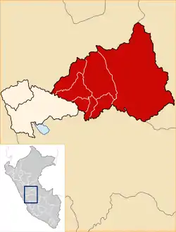 Location of Oxapampa in the Pasco Region | |
| Country | Peru |
| Region | Pasco |
| Founded | November 27, 1944 |
| Capital | Oxapampa |
| Government | |
| • Mayor | Juan Carlos La Torre Moscoso |
| Area | |
| • Total | 18,673.79 km2 (7,209.99 sq mi) |
| Population | |
| • Total | 96,169 (2,017) |
| UBIGEO | 1903 |
| Website | www |
| Year | Pop. | ±% |
|---|---|---|
| 1940 | 5,881 | — |
| 1961 | 25,783 | +338.4% |
| 1981 | 49,857 | +93.4% |
| 2007 | 81,829 | +64.1% |
| 2020 (est) | 100,561 | +22.9% |
| Source: [1][2] | ||
The Cerro de la Sal, an important source of salt for the indigenous people of the Amazon Basin since pre-historic times is located in the Villa Rica District of the province.The southeastern part of the province is the location of the Gran Pajonal (Great Grassland), an elevated plateau occupied by the Asháninka people.
Oxapampa is best known for the colonists from Austria and Germany who established one of the first European settlements (in Peru) east of the Andes in remote Pozuzo District in 1859 and founded the towns of Oxapampa in 1891 and Villa Rica in 1928. Traces of German culture remain in the architecture and culture of these districts.[5]
Political divisions
The Oxapampa Province is divided into eight districts (Spanish: distritos, singular: distrito), each of which is headed by a mayor (alcalde):
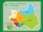
| Districts of Oxapampa Province[6] | ||||||
|---|---|---|---|---|---|---|
| District | Capital | Area | Population (1993) | Population (2017) | elevation (of capital) | coordinates |
| Chontabamba | Chontabamba | 450 km2 (170 sq mi) | 2,460 | 5,637 | 1,828 m (5,997 ft) | 10.603°S 75.439°W |
| Constitución | Ciudad Constitución | 3,053 km2 (1,179 sq mi) | Created 2010 | 15,230 | 232 m (761 ft) | 9.848°S 75.016°W |
| Huancabamba | Huancabamba | 1,237 km2 (478 sq mi) | 5,746 | 6,891 | 1,666 m (5,466 ft) | 10.426°S 75.525°W |
| Oxapampa District | Oxapampa | 412 km2 (159 sq mi) | 12,826 | 16,565 | 1,812 m (5,945 ft) | 10.574°S 75.405°W |
| Palcazú District | Iscozacín | 2,887 km2 (1,115 sq mi) | 5,687 | 8,257 | 275 m (902 ft) | 10.184°S 75.150°W |
| Pozuzo District | Pozuzo | 1,394 km2 (538 sq mi) | 5,053 | 5,128 | 731 m (2,398 ft) | 10.071°S 75.551°W |
| Puerto Bermúdez District | Puerto Bermúdez | 7,634 km2 (2,948 sq mi) | 13,787 (see note) | 19,968 | 258 m (846 ft) | 10.298°S 74.937°W |
| Villa Rica District | Villa Rica | 788 km2 (304 sq mi) | 14,739 | 18,763 | 1,466 m (4,810 ft) | 10.735°S 75.268°W |
| Total: Oxapampa | Oxapampa | 18,674 km2 (7,210 sq mi) | 60,298 | 96,169 | 1,812 m (5,945 ft) | |
Places of interest
_with_three_field_stations_-_ZooKeys-235-051-g002.jpeg.webp)
References
- Instituto Nacional de Estadística e Informática, Peru
- "Chapter 8 - Human Occupation of the Central Selva of Peru". Organization of American States. Retrieved 17 June 2020.
- (in Spanish) Official web site of the Oxapampa Province
- Google Earth
- Dilwyn Jenkins (2009-07-01). The Rough Guide to Peru. Rough Guides Limited. pp. 487–489. ISBN 978-1-84836-053-2.
- "Pasco Region". City Population. Retrieved 16 June 2020.
External links
- (in Spanish) Official web site of the Oxapampa Province
- (in Spanish) Pozuzo Information
| |
|---|---|