Paleoshoreline
A paleoshoreline is a shoreline which existed, in the geologic past; note paleo means old or ancient;[1] see perched coastline, a fossil coastline currently above the present coastline..
| Look up palaeoshoreline in Wiktionary, the free dictionary. |
Due to tides, the ocean advances and recedes, commonly twice per day. But sea level can advance and recede quite slowly, and finding paleoshorelines is more tricky. A lake may have a paleoshoreline.[2][3]
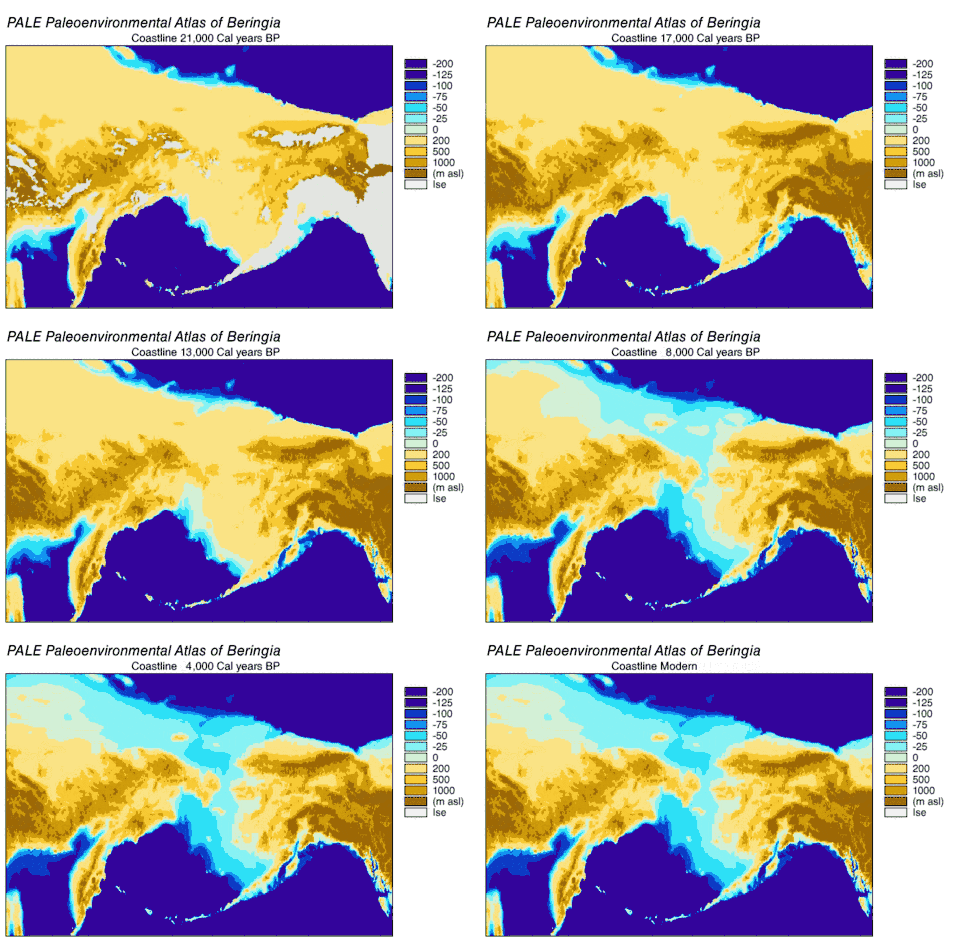
Just of the coastline of North America, in the last 15,000 years sea level has varied from over 100 metres (330 ft) below, to as high as 10 metres (33 ft) above its present level. That entire time, humans have lived in North America.[4]
Paleoshorelines have been inferred, on Mars;[5][6] see Burgsvik Beds and Martian dichotomy.

Why do paleoshorelines matter?
Paleoshorelines capture valuable records of environmental change and can tell us about modern shelf ecosystems. These structures can indicate distributions of seabed features that are habitat of marine life; they also may shed light on the location of coastal resources once used by humans, thus so are of archaeological significance.[7]
Examples
- The Bering Land Bridge once stood above water, and the commonest explanation is that the Native Americans came over this land bridge. Now it is underwater.[4]
- Once Doggerland stood above water, connecting Great Britain and Ireland to the rest of Europe.[8]
- In a sudden event, the 1700 Cascadia earthquake caused the coastline from what are now British Columbia, Washington, Oregon and north California to "drop several feet."[9]
- In Asia, the Yonaguni Monument once stood above sea level; whether the formations are human-made is still argued.[10]
References
- "paleo-". dictionary.com. Retrieved 2020-12-31.
- Komatsu, Goro. "Paleoshoreline geomorphology of Böön Tsagaan Nuur, Tsagaan Nuur and Orog Nuur: the Valley of Lakes, Mongolia". Retrieved 2021-01-01.
- Egger, A.E. (December 2012). "Paleoseismology from Paleoshorelines: Combining Lidar Data and Geochronology to Resolve Displacement of Pleistocene Pluvial Shorelines along Normal Faults in the Northwestern Basin and Range". AGU Fall Meeting Abstracts. 2012. Bibcode:2012AGUFMPP11A2003E. Retrieved 2021-01-01.
- "Paleoshoreline Research".
- Erkeling, Gino (November 20, 2015). Encyclopedia of Planetary Landforms. SrpingerLink. Bibcode:2015epl..book.....H. doi:10.1007/978-1-4614-3134-3_248. Retrieved 2020-12-29.
- Ruiz, Javier (November 20, 2003). "Should Paleoshorelines of ancient Martian Oceans be close to present-day equipotential Surfaces?". Proceedings of the Third European Workshop on Exo-Astrobiology. Bibcode:2004ESASP.545..281R.
- Barrett, Katherine (June 7, 2017). "Paleoshorelines, Time capsules of the ocean's ancient shorelines". Oceanbites. Retrieved 2020-12-29.
- "Doggerland - The Europe That Was". Retrieved 2020-12-31.
- "Cascadia Subduction Zone". oregon.gov. Retrieved 2020-12-31.
- Ryall, Julian. "Japan's Ancient Underwater "Pyramid" Mystifies Scholars". nationalgeographic.com. Retrieved 2020-12-31.
External links and references
- Paleoshoreline reseach
- Paleoshoerlines of Pacific islands
- Paleoshorelines off Australia
- Shelf sand supply determined by glacial-age sea-level modes, submerged coastlines and wave climate
- Paleoshorelines off Tonga
- Paleoshoreline evidence for postglacial tilting in Southern Manitoba
- Paleoshorelines of Florida, USA
- Submerged Shorelines in the Southern California Borderland
- Paleoshorelines of Mono Lake, California, USA