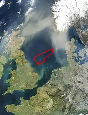
Doggerland
Doggerland (also called Dogger Littoral[1]) was an area of land, now submerged beneath the southern North Sea, that connected Great Britain to continental Europe. It was flooded by rising sea levels around 6500–6200 BCE. Geological surveys have suggested that it stretched from where Great Britain's east coast now is to the present-day Netherlands, western coast of Germany, and peninsula of Jutland.[2] It was probably a rich habitat with human habitation in the Mesolithic period,[3] although rising sea levels gradually reduced it to low-lying islands before its final submergence, possibly following a tsunami caused by the Storegga Slide.[4] Doggerland was named after the Dogger Bank, which in turn was named after 17th-century Dutch fishing boats called doggers.[5]
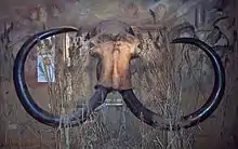
The archaeological potential of the area was first identified in the early 20th century, and interest intensified in 1931 when a fishing trawler operating east of the Wash dragged up a barbed antler point that was subsequently dated to a time when the area was tundra. Vessels have dragged up remains of mammoths, lions and other animals, and a few prehistoric tools and weapons.[6]
As of 2020 international teams are continuing a two year investigation into the submerged landscape of Doggerland using new and traditional archaeo-geophysics techniques, computer simulation and molecular biology. Evidence gathered allows study of past environments, ecological change and human transition from hunter-gatherer to farming communities.[7]
Formation
Until the middle Pleistocene, Great Britain was a peninsula of Europe, connected by the massive chalk Weald–Artois Anticline across the Straits of Dover. During the Anglian glaciation, approximately 450,000 years ago, an ice sheet filled much of the North Sea, with a large proglacial lake in the southern part fed by the Rhine, Scheldt and Thames river systems. The catastrophic overflow of this lake carved a channel through the anticline, leading to the formation of the Channel River, which carried the combined Rhine, Scheldt, and Thames to the Atlantic. This probably created the potential for Britain to become isolated from the continent during periods of high sea level, although some scientists argue that the final break did not occur until a second ice-dammed lake overflowed during the MIS8 or MIS6 glaciations, around 340,000 or 240,000 years ago.[8]
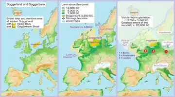
During the most recent glaciation of the Last Glacial Maximum, which ended around 18,000 years ago, the North Sea and much of the British Isles were covered with glacial ice and the sea level was about 120 m (390 ft) lower. The climate later became warmer and during the Late Glacial Maximum around 12,000 BCE Britain, as well as much of the North Sea and English Channel, was an expanse of low-lying tundra.[9]
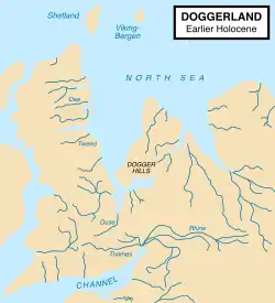
Evidence, including the contours of the present seabed, indicates that after the first main Ice Age, the watershed between the North Sea and English Channel extended east from East Anglia then south-east to the Hook of Holland, rather than across the Strait of Dover. The Seine, Thames, Meuse, Scheldt and Rhine rivers joined and flowed west along the English Channel as a wide slow river before eventually reaching the Atlantic Ocean.[3][9] At about 10,000 BCE the north-facing coastal area of Doggerland had a coastline of lagoons, saltmarshes, mudflats and beaches as well as inland streams, rivers, marshes and lakes. It may have been the richest hunting, fowling and fishing ground in Europe in the Mesolithic period.[3][10]
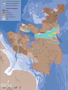
One big river system found by 3D seismic survey, undertaken by the Birmingham "North Sea Palaeolandscapes Project," was the "Shotton River", which drained the south-east part of the Dogger Bank hill area into the east end of the Outer Silver Pit lake. It is named after Birmingham geologist Frederick William Shotton.
Disappearance
As ice melted at the end of the last glacial period of the current ice age, sea levels rose and the land began to tilt in an isostatic adjustment as the huge weight of ice lessened. Doggerland eventually became submerged, cutting off what was previously the British peninsula from the European mainland by around 6500 BCE.[9][12] The Dogger Bank, an upland area of Doggerland, remained an island until at least 5000 BCE.[9][12] Key stages are now believed to have included the gradual evolution of a large tidal bay between eastern England and Dogger Bank by 9000 BCE and a rapid sea level rise thereafter, leading to Dogger Bank becoming an island and Britain becoming physically disconnected from the continent.[13]
A recent hypothesis suggests that much of the remaining coastal land was flooded by a megatsunami around 6200 BCE, caused by a submarine landslide off the coast of Norway known as the Storegga Slide. This suggests: "that the Storegga Slide tsunami would have had a catastrophic impact on the contemporary coastal Mesolithic population.... Britain finally became separated from the continent and in cultural terms, the Mesolithic there goes its own way."[13] A study published in 2014 suggested that the only remaining parts of Doggerland at the time of the Storegga Slide were low-lying islands, but supported the view that the area had been abandoned at about the same time as the tsunamis.[4]
Another view speculates that the Storegga tsunami devastated Doggerland but then ebbed back into the sea, and that later Lake Agassiz (in North America) burst releasing so much fresh water that sea levels over about two years rose to flood much of Doggerland and make Britain an island.[14] The difference in distribution of broken shells between lower-lying and high-lying parts of the area also suggest survival of land after the Storegga tsunami.[15]
Discovery and investigation by archaeologists
The prehistoric existence of what is now known as Doggerland was established in the late 19th century. H. G. Wells referred to the concept in his short story A Story of the Stone Age of 1897, set in "a time when one might have walked dryshod from France (as we call it now) to England, and when a broad and sluggish Thames flowed through its marshes to meet its father Rhine, flowing through a wide and level country that is underwater in these latter days, and which we know by the name of the North Sea...Fifty thousand years ago it was, fifty thousand years if the reckoning of geologists is correct", though most of the action seems to occur in what is now Surrey and Kent, but stretching out to Doggerland.[16]
The remains of plants brought to the surface from Dogger Bank were studied in 1913 by paleobiologist Clement Reid, and the remains of animals and worked flints from the Neolithic period had also been found.[17] In his book The Antiquity of Man of 1915, anatomist Sir Arthur Keith discussed the archaeological potential of the area.[17] In 1931, the trawler Colinda hauled up a lump of peat whilst fishing near the Ower Bank, 40 km (25 mi) east of Norfolk. The peat was found to contain a barbed antler point, possibly used as a harpoon or fish spear, 220 mm (8.5 in) long, which dated from between 4000 and 10,000 BCE when the area was tundra.[3][10]
Interest was reinvigorated in the 1990s by Bryony Coles, who named the area "Doggerland" ("after the great banks in the southern North Sea")[10] and produced speculative maps of the area.[10][18] Although she recognised that the current relief of the southern North Sea seabed is not a sound guide to the topography of Doggerland,[18] this topography has more recently begun to be reconstructed more authoritatively using seismic survey data obtained from oil exploration. Between 2003 and 2007 a team at the University of Birmingham led by Vince Gaffney and Ken Thomson mapped around 23,000 km2 (8,900 sq mi) of the Early Holocene landscape, using seismic data provided for research by Petroleum Geo-Services, as part of the work of the University of Birmingham North Sea Palaeolandscapes Project.[19] The results of this study were published as a technical monograph and a popular book on the history and archaeology of Doggerland.[20][21][22] Names have been given to some of its features: "The Spines" to a system of dunes above the broad "Shotton River", the upland area of the "Dogger Bank", a basin between two huge sandbanks called "The Outer Silver Pit".[23]
A skull fragment of a Neanderthal, dated at over 40,000 years old, was recovered from material dredged from the Middeldiep, some 16 km (10 mi) off the coast of Zeeland, and exhibited in Leiden in 2009.[24] In March 2010 it was reported that recognition of the potential archaeological importance of the area could affect the future development of offshore wind farms.[25] In 2019 a flint flake partially covered in birch bark tar dredged up off the coast of the Netherlands provided valuable insight into Neanderthal technology and cognitive evolution.[26]
In July 2012, the results of study of Doggerland by the universities of Birmingham, St Andrews, Dundee, and Aberdeen, including surveys of artefacts, were displayed at the Royal Society summer exhibition in London.[27] Richard Bates of St Andrews University said:[27]
We have speculated for years on the lost land's existence from bones dredged by fishermen all over the North Sea, but it's only since working with oil companies in the last few years that we have been able to re-create what this lost land looked like.... We have now been able to model its flora and fauna, build up a picture of the ancient people that lived there and begin to understand some of the dramatic events that subsequently changed the land, including the sea rising and a devastating tsunami.
Since 2015, the University of Bradford's Europe's Lost Frontiers[28] project has continued mapping the prehistoric landscapes of Doggerland and has used this data to direct a programme of extensive coring of marine palaeochannels. Sediment from the cores has provided sedimentary DNA as well as conventional environmental data and these will be used in a major computational modelling programme replicating colonisation of the submerged landscape.[29][30]
In June 2019, a team of scientists from the University of Bradford and Ghent University found a hammerstone flint on the seabed 40 km (25 mi) off the coast of Cromer, Norfolk, from a depth of 32 m (105 ft), which could point to the existence of prehistoric settlements.[31][32]
Ancient artifacts are found by beachcombers in material dredged from the sea bottom 13 km (8.1 mi) offshore and spread on a Dutch beach in 2012 as a coastal protection measure.[33]
In media
- The area featured in a 2007 episode of the Channel 4 Time Team documentary series called "Britain's Drowned World".[34][lower-alpha 1]
See also
- Sunken continent
- Maglemosian culture
- Outburst flood
- Paleoshoreline
- Weald–Artois Anticline
Notes
- Technical advice for Britain's Lost World was provided by Vincent Gaffney, co-author of Europe's Lost World: The Rediscovery of Doggerland, and the presenter of the programme, Tony Robinson, wrote a foreword to the book.[35]
References
- Bob Yirka (2 December 2020). "Sediment cores from Dogger Littoral suggest Dogger Island survived ancient tsunami". phys.org. Retrieved 2 January 2021.
- "The Doggerland Project", University of Exeter Department of Archaeology
- Patterson, W, "Coastal Catastrophe" (paleoclimate research document), University of Saskatchewan Archived 9 April 2008 at the Wayback Machine
- Rincon, Paul (1 May 2014). "Prehistoric North Sea 'Atlantis' hit by 5m tsunami". BBC News.
- . Encyclopædia Britannica. 08 (11th ed.). 1911. pp. 380 to 381.
- White, Mark J. (24 November 2006). "Things to do in Doggerland when you're dead: Surviving OIS3 at the northwesternmost fringe of Middle Palaeolithic Europe" (PDF). World Archaeology. 38 (4): 547–575. doi:10.1080/00438240600963031. S2CID 51729868.
- The first archaeological artefacts found during the search for lost prehistoric settlements in the North Sea
- Pettitt, Paul; White, Mark (2012). The British Palaeolithic: Human Societies at the Edge of the Pleistocene World. Abingdon, UK: Routledge. pp. 98–102, 277. ISBN 978-0-415-67455-3.
- University of Sussex, School of Life Sciences Archived 9 June 2011 at the Wayback Machine, C1119 Modern human evolution, Lecture 6, slide 23
- Vincent Gaffney, "Global Warming and Lost Lands: Understanding the Effects of Sea Level Rise"
- Stride, A.H (January 1959). "On the origin of the Dogger Bank, in the North Sea". Geological Magazine. 96 (1): 33–34. doi:10.1017/S0016756800059197. Retrieved 12 January 2010.
- Scarre, Chris (2005). The Human Past: World Prehistory & the Development of Human Societies. London: Thames & Hudson. p. 180. ISBN 978-0-500-28531-2.
- Bernhard Weninger et al., The catastrophic final flooding of Doggerland by the Storegga Slide tsunami, Documenta Praehistorica XXXV, 2008
- Britain's Stone Age Tsunami, Channel 4, 8 to 9 pm, Thursday 30 May 2013
- James Walker; et al. (2020). "A great wave: the Storegga tsunami and the end of Doggerland?". 94 (378). Antiquity. pp. 1409–1425. doi:10.15184/aqy.2020.49.
- Online text
- Keith, Arthur (15 August 2004). "3". The Antiquity of Man. Anmol Publications Pvt Ltd. p. 41. ISBN 81-7041-977-8. Retrieved 12 January 2010.
- B.J. Coles. "Doggerland : a speculative survey (Doggerland : une prospection spéculative)", Proceedings of the Prehistoric Society, ISSN 0079-497X, 1998, vol. 64, pp. 45–81 (3 p.1/4)
- North Sea Palaeolandscapes Project
- Laura Spinney, "The lost world: Doggerland"
- Vincent L. Gaffney; Kenneth Thomson; Simon Fitch, eds. (2007). Mapping Doggerland: The Mesolithic Landscapes of the Southern North Sea. Archaeopress. p. 11. ISBN 978-1-905739-14-1.
- Vincent Gaffney, Simon Fitch, David Smith, Europe's Lost World: The rediscovery of Doggerland, University of Birmingham, 2009
- Robert Macfarlane (2012). The Old Ways. Penguin. pp. 70–71. ISBN 978-0-141-03058-6.
- Palarch: Spectacular discovery of first-ever Dutch Neanderthal Fossil skull fragment unveiled by Minister Plasterk in National Museum of Antiquities, 15 June 2009
- "Stone Age could complicate N. Sea wind farm plans", Reuters, 23 March 2010
- Niekus, Marcel J. L. Th.; Kozowyk, Paul R. B.; Langejans, Geeske H. J.; Ngan-Tillard, Dominique; van Keulen, Henk; van der Plicht, Johannes; Cohen, Kim M.; van Wingerden, Willy; van Os, Bertil; Smit, Bjørn I.; Amkreutz, Luc W. S. W. (21 October 2019). "Middle Paleolithic complex technology and a Neandertal tar-backed tool from the Dutch North Sea". Proceedings of the National Academy of Sciences. 116 (44): 22081–22087. doi:10.1073/pnas.1907828116. ISSN 0027-8424. PMC 6825292. PMID 31636186.
- BBC News, "Hidden Doggerland underworld uncovered in North Sea", 3 July 2012. Accessed 4 July 2012
- https://lostfrontiers.teamapp.com/
- App, Team. "Lost Frontiers (Lost Frontiers) Home page - Lost Frontiers An Erc Research Project team/club based in University of Bradford, United Kingdom. | Team App". Lost Frontiers. Retrieved 8 May 2017.
- Sarah Knapton (1 September 2015). "British Atlantis: archaeologists begin exploring lost world of Doggerland". Daily Telegraph. London. Retrieved 2 September 2015.
- "Evidence of human life found under North Sea off Cromer". BBC News. 12 June 2019.
- https://www.bradford.ac.uk/news/archive/2019/the-first-archaeological-artefacts-found-during-the-search-for-lost-prehistoric-settlements-in-the-north-sea.php
- "Lost world revealed by human, Neanderthal relics washed up on North Sea beaches". 30 January 2020.
- Heritage Action
- Gaffney, Fitch & Smith 2009, p. foreword.
Further reading
- Coles, B. J. (1998). "Doggerland: a Speculative Survey". Proceedings of the Prehistoric Society. 64: 45–81. doi:10.1017/S0079497X00002176.
- Gaffney, V.; Thomson, K.; Fitch, S., eds. (2007). Mapping Doggerland: The Mesolithic Landscapes of the Southern North Sea. https://www.academia.edu/2480682/Mapping_Doggerland_the_Mesolithic_Landscapes_of_the_Southern_North_Sea: Archaeopress.CS1 maint: location (link)
- Gaffney, Vincent; Fitch, Simon; Smith, David (2009). Europe's Lost World: The Rediscovery of Doggerland. Council for British Archaeology. ISBN 978-1-902771-77-9.
- Walker, James; Gaffney, Vincent; Fitch, Simon; Muru, Merle; Fraser, Andrew; Bates, Martin; Bates, Richard (2020). "A great wave: the Storegga tsunami and the end of Doggerland?". Antiquity. 94 (378): 1409–1425. doi:10.15184/aqy.2020.49. ISSN 0003-598X.
- Moffat, Alistair (2005). Before Scotland: The Story of Scotland Before History. Thames & Hudson. ISBN 978-0-500-05133-7. Discussed in depth in chapters 2–4.
- Morelle, Rebecca (4 April 2017). "Evidence of ancient 'geological Brexit' revealed". BBC News. Retrieved 5 April 2017.
- Spinney, Laura (December 2012). Robert Clark (photog.); Alexander Maleev (illus.). "The Lost World of Doggerland". National Geographic. 222 (6): 132–143. Retrieved 30 November 2012.
External links
| Wikimedia Commons has media related to Doggerland. |
- "Hunting for DNA in Doggerland, an Ancient Land Beneath the North Sea", Elizabeth Preston, Wired, 27 November 2015
- "The moment Britain became an island", Megan Lane, BBC News, 15 February 2011
- "North Sea Paleolandscapes", Institute for Archaeology and Antiquity, University of Birmingham
- Britain's 'Atlantis’ found
- "North Sea Prehistory Research and Management Framework (NSPRMF) 2009", English Heritage, 2009
- "The Doggerland project", Professor Bryony Coles, University of Exeter. Includes hypothesised map of Doggerland in the early Holocene.
- CGI images (2 stills and a movie) of a Mesolithic camp beside the Shotton River
- "Das rekonstruierte Doggerland" ("Doggerland reconstructed"), computer generated images of a Doggerland landscape, 19 August 2008, Der Spiegel (in German)
- "Hidden Doggerland underworld uncovered in North Sea", BBC News, 3 July 2012
- Europe's Lost Frontiers
- 2013 European Heritage Prize awarded to M. Daniel Thérond and Professor Vincent Gaffney#
- Mapping Doggerland: the Mesolithic Landscapes of the southern North Sea
- Maps of a now-submerged land help reconstruct the lives of ancient Europeans on YouTube Feb 13, 2020 Science (journal)
- Evidence of settlements on Doggerland