Palomas Formation
The Palomas Formation is a geologic formation exposed in the southern Rio Grande rift of New Mexico. It preserves fossils dating back to the Pleistocene to Quaternary.[1]
| Palomas Formation Stratigraphic range: Pleistocene to Quaternary | |
|---|---|
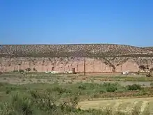 Palomas Formation (pink beds in erosional escarpment) near its type section, Palomas Creek, New Mexico, USA | |
| Type | Formation |
| Unit of | Santa Fe Group |
| Overlies | Hayner Ranch Formation |
| Thickness | 300–2,000 feet (91–610 m) |
| Lithology | |
| Primary | conglomerate |
| Other | Sandstone, siltstone |
| Location | |
| Coordinates | 33.054546°N 107.2957969°W |
| Region | New Mexico |
| Country | United States |
| Type section | |
| Named for | Palomas River |
| Named by | C.H. Gordon |
| Year defined | 1907 |
 Palomas Formation (the United States) 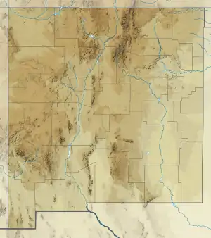 Palomas Formation (New Mexico) | |
Description
The formation is composed of beds of poorly cemented conglomerate, sandstone, and siltstone, with a total thickness of 300–2,000 feet (91–610 m).[2][1] The formation is better cemented to the west, where it resembles the Gila Formation.[2] The formation includes both piedmont and axial river facies. The conglomerate is gray to brown, poorly to moderately sorted, and contains clasts of tuff, basalt, rhyolite, and andesite up to 40 centimetres (16 in) long. The siltstone is well-sorted and trough-crossbedded. The formation may correlate with the Sierra Ladrones Formation to the north and the Camp Rice Formation to the south. The age is estimated as 5 Ma to 0.4 Ma.</ref>[1]
Basalt flows lying on a geomorphic surface cut in the formation yield a radiometric age of 2.1 and 2.2 Ma.[3]
Fossils
The lower part of the formation contains fossil mammals and reptiles, including turtles, lizards, snakes, rabbits, rats, gophers, mastodons, horses, and deer. Paleomagnetic dating gives an age for this bed of 4.05 to 4.20 Ma.[4]
History of investigation
The unit was first named the Palomas Gravel by C.H. Gordon in 1907.[2] It was renamed the Palomas Formation and assigned to the upper Santa Fe Group by Lozinsky and Hawley in 1986.[1] However, Reppening and May regard it as post-Santa Fe.[4]
Footnotes
References
- Gordon, C.H.; Graton, L.C. (1907). "Lower Paleozoic formations in New Mexico". Journal of Geology. 15 (1): 91–92. Bibcode:1907JG.....15...91.. doi:10.1086/621378. PMID 17797346.
- Lozinsky, R.P.; Hawley, J.W. (1986). "The Palomas Formation of south-central New Mexico; a formal definition" (PDF). New Mexico Geology. 8 (4): 73–78, 82. Retrieved 14 August 2020.
- Maxwell, C.H.; Oakman, M.R. (1990). "Geologic map of the Cuchillo quadrangle, Sierra County, New Mexico". U.S. Geological Survey Geologic Quadrangle Map. GQ-1686. Retrieved 31 July 2020.
- Repenning, C.A.; May, S.R. (1986). "New evidence for the age of the lower part of the Palomas Formation, Truth or Consequences, New Mexico" (PDF). New Mexico Geological Society Field Conference Guidebook. 37: 257. Retrieved 31 July 2020.