Pandora, Ohio
Pandora is a village in Putnam County, Ohio, United States, located on the Riley Creek. The population was 1,153 at the 2010 census.
Pandora, Ohio | |
|---|---|
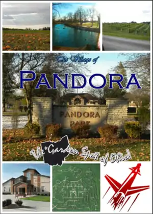 The Village of Pandora | |
| Motto(s): The Garden Spot of Ohio | |
 Location of Pandora, Ohio | |
 Location of Pandora in Putnam County | |
| Coordinates: 40°56′49″N 83°57′36″W | |
| Country | United States |
| State | Ohio |
| County | Putnam |
| Area | |
| • Total | 1.08 sq mi (2.81 km2) |
| • Land | 1.07 sq mi (2.76 km2) |
| • Water | 0.02 sq mi (0.04 km2) |
| Elevation | 774 ft (236 m) |
| Population | |
| • Total | 1,153 |
| • Estimate (2019)[4] | 1,107 |
| • Density | 1,038.46/sq mi (401.05/km2) |
| Time zone | UTC-5 (Eastern (EST)) |
| • Summer (DST) | UTC-4 (EDT) |
| ZIP code | 45877 |
| Area code(s) | 419 |
| FIPS code | 39-59738[5] |
| GNIS feature ID | 1085224[2] |
| Website | pandoraoh.com villageofpandora.com |
History
Pandora was originally called Columbia, and under the latter name was laid out in 1837.[6] Another early variant name was Pendleton.[7] A post office was established as Pendleton in 1837, and the name was changed to Pandora in 1883.[8] Pandora was incorporated as a village in 1892.[9]
Geography
Pandora is located at 40°56′49″N 83°57′36″W (40.946883, -83.959905).[10]
According to the United States Census Bureau, the village has a total area of 0.92 square miles (2.38 km2), of which 0.90 square miles (2.33 km2) is land and 0.02 square miles (0.05 km2) is water.[11]
Demographics
| Historical population | |||
|---|---|---|---|
| Census | Pop. | %± | |
| 1890 | 568 | — | |
| 1900 | 675 | 18.8% | |
| 1910 | 800 | 18.5% | |
| 1920 | 669 | −16.4% | |
| 1930 | 588 | −12.1% | |
| 1940 | 690 | 17.3% | |
| 1950 | 717 | 3.9% | |
| 1960 | 782 | 9.1% | |
| 1970 | 857 | 9.6% | |
| 1980 | 977 | 14.0% | |
| 1990 | 1,009 | 3.3% | |
| 2000 | 1,188 | 17.7% | |
| 2010 | 1,153 | −2.9% | |
| 2019 (est.) | 1,107 | [4] | −4.0% |
| U.S. Decennial Census[12] | |||
2010 census
As of the census[3] of 2010, there were 1,153 people, 452 households, and 320 families living in the village. The population density was 1,281.1 inhabitants per square mile (494.6/km2). There were 486 housing units at an average density of 540.0 per square mile (208.5/km2). The racial makeup of the village was 97.2% White, 0.3% African American, 0.3% Native American, 1.6% from other races, and 0.6% from two or more races. Hispanic or Latino of any race were 3.4% of the population. 56.8% were of German, 18.0% Swiss, 11.7% Irish, 8.7% English, and 5.9% French descent.[13]
There were 452 households, of which 31.9% had children under the age of 18 living with them, 58.8% were married couples living together, 8.2% had a female householder with no husband present, 3.8% had a male householder with no wife present, and 29.2% were non-families. 27.0% of all households were made up of individuals, and 10.9% had someone living alone who was 65 years of age or older. The average household size was 2.43 and the average family size was 2.91.
The median age in the village was 40 years. 24.4% of residents were under the age of 18; 6.8% were between the ages of 18 and 24; 25.6% were from 25 to 44; 24.6% were from 45 to 64; and 18.6% were 65 years of age or older. The gender makeup of the village was 49.1% male and 50.9% female.
2000 census
As of the census[5] of 2000, there were 1,188 people, 442 households, and 331 families living in the village. The population density was 1,462.0 people per square mile (566.3/km2). There were 458 housing units at an average density of 563.7 per square mile (218.3/km2). The racial makeup of the village was 98.74% White, 0.34% African American, 0.59% from other races, and 0.34% from two or more races. Hispanic or Latino of any race were 1.26% of the population.
There were 442 households, out of which 35.5% had children under the age of 18 living with them, 64.7% were married couples living together, 6.3% had a female householder with no husband present, and 25.1% were non-families. 22.6% of all households were made up of individuals, and 10.9% had someone living alone who was 65 years of age or older. The average household size was 2.51 and the average family size was 2.96.
In the village, the population was spread out, with 24.8% under the age of 18, 7.7% from 18 to 24, 27.5% from 25 to 44, 19.6% from 45 to 64, and 20.4% who were 65 years of age or older. The median age was 38 years. For every 100 females there were 90.4 males. For every 100 females age 18 and over, there were 86.0 males.
The median income for a household in the village was $42,174, and the median income for a family was $49,500. Males had a median income of $36,597 versus $21,830 for females. The per capita income for the village was $17,816. About 2.7% of families and 4.0% of the population were below the poverty line, including 2.5% of those under age 18 and 4.7% of those age 65 or over.
Education
Pandora-Gilboa Local Schools operates one elementary school, one middle school, and Pandora-Gilboa High School.[14]
Pandora has a public library, a branch of the Putnam County District Library.[15]
Notable people
- Cyrus Locher, United States Senator
- Benjamin F. Welty, United States Representative
- Arthur H. Day, Ohio state senator and served a six-year term as an Ohio Supreme Court justice
- Nathan Hancock, The original "emperor of Pangea" and now runs a multi-million dollar healthcare staffing company based in Atlanta, Georgia.
References
| Wikimedia Commons has media related to Pandora, Ohio. |
- "2019 U.S. Gazetteer Files". United States Census Bureau. Retrieved July 28, 2020.
- "US Board on Geographic Names". United States Geological Survey. 2007-10-25. Retrieved 2008-01-31.
- "U.S. Census website". United States Census Bureau. Retrieved 2013-01-06.
- "Population and Housing Unit Estimates". United States Census Bureau. May 24, 2020. Retrieved May 27, 2020.
- "U.S. Census website". United States Census Bureau. Retrieved 2008-01-31.
- "History". Village of Pandora, OH. Archived from the original on 15 January 2016. Retrieved 7 January 2016.
- Warren, Robert (May 31, 1953). "Blanchard River Brought Pioneers To Putnam". Toledo Blade. p. 3. Retrieved 30 April 2015.
- "Putnam County". Jim Forte Postal History. Retrieved 30 April 2015.
- Kinder, George D. (1915). History of Putnam County, Ohio : its peoples, industries, and institutions. B.F. Bowen. p. 154.
- "US Gazetteer files: 2010, 2000, and 1990". United States Census Bureau. 2011-02-12. Retrieved 2011-04-23.
- "US Gazetteer files 2010". United States Census Bureau. Archived from the original on 2012-01-24. Retrieved 2013-01-06.
- "Census of Population and Housing". Census.gov. Retrieved June 4, 2015.
- Data Access and Dissemination Systems (DADS). "American FactFinder - Results". census.gov. Archived from the original on 2020-02-12.
- "Homepage". Pandora-Gilboa Local Schools. Retrieved 3 March 2018.
- "Branch Locations". Putnam County District Library. Archived from the original on 4 March 2018. Retrieved 3 March 2018.
- http://www.putnamsentinel.com/Content/News/Local-News/Article/Ted-Fest-will-feature-sand-sculpture/1/1/20605
- https://roundtown.com/event/10924198/Tedfest-2015-Pandora-OH%5B%5D
- https://www.facebook.com/events/402242899885503/
Municipalities and communities of Putnam County, Ohio, United States | ||
|---|---|---|
| Villages | 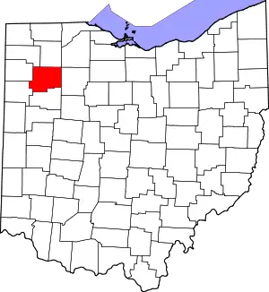 Map of Ohio highlighting Putnam County | |
| Townships | ||
| CDP | ||
| Unincorporated communities | ||
| Ghost towns | ||
| ||
