Papamoa
Papamoa or Papamoa Beach is a suburb of Tauranga, located about 11 kilometres from the city centre. It is the largest residential suburb in Tauranga.[2] It is bordered to the west by Arataki and Mount Maunganui (east of Sunrise Avenue and Hibiscus Avenue), the east by the Kaituna River (separating it from the Western Bay of Plenty District) and to the south by State Highway 2.


History and culture
Māori settlement of Papamoa dates back to approximately 1400 ce with a significant pā complex overlooking the fertile plains and abundant coastal fisheries. For the next 300 years the people prospered, harvesting their crops and fisheries, occupying and abandoning sites in accordance with the kūmara cycle and soil fertility.[3]
Papamoa has 16 km (9.9 mi) of white sandy beach stretching from the boundary with Mount Maunganui in the west to the Kaituna River in the east. Widespread Pākehā settlement of the area did not start until the early 1960s and prior to this Papamoa had been largely a rural area. Once a small and tight knit community, many of Papamoa Beach's sweeping paddocks have been swallowed up by urban development.
In subsequent decades, Papamoa is currently one of the fastest growing suburbs of Tauranga, with many different subdivisions developing concurrently on different blocks of land on the fringes of the suburb. It is popular for fishing, surfing, and as a holiday retreat.
The local Mangatawa or Tamapahore Marae and its Tamapahore meeting house is a meeting place for the Ngāi Te Rangi hapū of Ngā Pōtiki.[4][5]
Nudity
Papamoa Beach is a clothing-optional beach by custom.[6][7] New Zealand has no official nude beaches, as public nudity is legal on any beach where it is "known to occur".[8] Sexual activity in public places is illegal, however, and Papamoa Beach has been the site of a continuing series of complaints about lewd behaviour. Some complainants take care to distinguish between these activities and non-sexual naturism; others do not.[9][10][11][12]
In 2012, Papamoa Beach was the location for a skinny dipping world record attempt. On 2 December 2012, 299 people got naked in the water as the nearby Baywatch campsite in Gisborne hosted the event. Despite a cold day, many people stripped naked attempting to beat Christchurch's Summer Beach Dip. The record failed as Guinness World Records required all swimmers to be in the water at the same time for a group photo.[13]
Name issues
The suburban area of "Papamoa" as it is commonly referred to today is actually situated at "Papamoa Beach." Strictly geographically speaking, "Papamoa" is actually located closer inland towards the Papamoa Hills, in an area covered by the Western Bay of Plenty District Council. Papamoa (situated at Papamoa Beach) can be split into two areas: Papamoa East and Papamoa West. Legally speaking, Domain Road separates Papamoa West from Papamoa East, although to many locals Papamoa East starts on the Eastern side of Parton Road. Papamoa East (of Parton Road) in the 1970s and 1980s used to be seen as more of an alternative place to live, a bit like the Coromandel Peninsula.
Demographics
| Year | Pop. | ±% p.a. |
|---|---|---|
| 2006 | 16,176 | — |
| 2013 | 19,344 | +2.59% |
| 2018 | 25,272 | +5.49% |
| Source: [1] | ||
Papamoa, comprising the statistical areas of Pacific View, Palm Beach North, Palm Beach South-Gravatt, Papamoa Beach North, Doncaster, Papamoa Beach South, Motiti and Wairakei, had a population of 25,272 at the 2018 New Zealand census, an increase of 5,928 people (30.6%) since the 2013 census, and an increase of 9,096 people (56.2%) since the 2006 census. There were 9,006 households. There were 12,300 males and 12,972 females, giving a sex ratio of 0.95 males per female, with 5,805 people (23.0%) aged under 15 years, 3,963 (15.7%) aged 15 to 29, 11,232 (44.4%) aged 30 to 64, and 4,275 (16.9%) aged 65 or older.
Ethnicities were 85.3% European/Pākehā, 17.2% Māori, 2.8% Pacific peoples, 6.4% Asian, and 2.3% other ethnicities (totals add to more than 100% since people could identify with multiple ethnicities).
The proportion of people born overseas was 22.7%, compared with 27.1% nationally.
Although some people objected to giving their religion, 56.6% had no religion, 30.6% were Christian, 0.8% were Hindu, 0.3% were Muslim, 0.4% were Buddhist and 4.4% had other religions.
Of those at least 15 years old, 3,579 (18.4%) people had a bachelor or higher degree, and 3,405 (17.5%) people had no formal qualifications. The employment status of those at least 15 was that 9,612 (49.4%) people were employed full-time, 2,892 (14.9%) were part-time, and 645 (3.3%) were unemployed.[1]
| Name | Population | Median age | Median income |
|---|---|---|---|
| Pacific View | 3,015 | 40.6 years | $34,300[14] |
| Palm Beach North | 3,201 | 32.9 years | $30,900[15] |
| Palm Beach South-Gravatt | 3,750 | 51.7 years | $30,800[16] |
| Papamoa Beach North | 2,790 | 34.1 years | $33,100[17] |
| Doncaster | 3,159 | 36.1 years | $31,200[18] |
| Papamoa Beach South | 2,700 | 39.1 years | $31,400[19] |
| Motiti | 3,312 | 39.9 years | $36,700[20] |
| Wairakei | 3,345 | 36.2 years | $34,700[21] |
| New Zealand | 37.4 years | $31,800 |
Economy
Papamoa Beach has a large shopping area located to the west of Domain Road,. There is a small section of industrial activity located to the east of Parton Road.
Retail
Papamoa Plaza, a shopping centre covering 14,120 m², opened in 1997.[22] It has 650 carparks and 39 shops, including Countdown and The Warehouse.[23]
Fashion Island, another shopping centre covering 3,315 m², opened in 2006.[24] It has 20 stores.[25]
Education
Papamoa College is a co-educational state secondary school for Year 7 to 13 students,[26] established in 2011,[27] with a roll of 1545.[28]
Papamoa has three co-educational state primary schools for Year 1 to 6 students: Papamoa Primary School,[29][30] with a roll of 662;[31] Golden Sands School, established in 2011,[32][33] with a roll of 627;[34] and Te Okuroa Drive School, opening in 2021.[35][36]
Tahatai Coast School is a co-educational state primary school for Year 1 to 8 students established in 1996,[37][38] with a roll of 724.[39]
Te Akau ki Papamoa Primary School is a co-educational state primary school established in 2000,[40][41] with a roll of 630. The school originally took Year 1 to 8, but removed Year 7 and 8 when Papamoa College opened.[42]
Te Kura Kaupapa Māori o Te Kura Kokiri is a co-educational Māori language immersion state primary school,[43][44] with a roll of 205.[45]
Suzanne Aubert Catholic School is a state integrated Catholic primary school which is due to open at the beginning of 2021.[46]
Transport
Public transport in Papamoa Beach solely consists of bus services. The suburb is served by three 'Bay Hopper' routes; Route 30 (Mount Maunganui - Papamoa ), Route 33 (Tauranga - Papamoa via the Harbour Bridge), and Route 36 (Tauranga - Papamoa via Maungatapu Bridge).[47]
Gallery
| Wikimedia Commons has media related to Papamoa. |
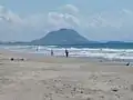 Mt Maunganui from Papamoa Beach
 Papamoa Beach from the Papamoa Domain
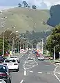 The Papamoa Hills from Domain Rd
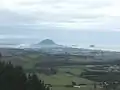 Looking towards Mt Maunganui from the Papamoa Hills
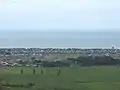 Looking down at Papamoa from the top of the Papamoa Hills
 Looking towards Parton Rd and Motiti Island from the Papamoa Hills
References
- "Statistical area 1 dataset for 2018 Census". Statistics New Zealand. March 2020. Pacific View (196800), Palm Beach North (197000), Palm Beach South-Gravatt (197100), Papamoa Beach North (197200), Doncaster (197300), Papamoa Beach South (197400), Motiti (197500) and Wairakei (197600).
- "Papamoa set for growth boom". Bay of Plenty Times. 12 July 2015.
- https://nzhistory.govt.nz/media/photo/papamoa
- "Te Kāhui Māngai directory". tkm.govt.nz. Te Puni Kōkiri.
- "Māori Maps". maorimaps.com. Te Potiki National Trust.
- "Papamoa Beach". Free Beaches NZ Inc. Retrieved 28 November 2019.
- Coates, Joe (28 January 2018). "The Best Nudist Beaches in New Zealand". culture trip. Retrieved 28 November 2019.
- Ceramalus v Police, AP No 76/91 (High Court of New Zealand 5 July 1991).
- "Nudist warning for Papamoa". New Zealand Herald. 21 May 2011. Retrieved 28 November 2019.
- Wall, Tony (29 April 2012). "Residents draw line in the sand on nudity". Stuff.co.nz. Stuff Nation. Retrieved 28 November 2019.
- "Battle for the beach: Nudists clash with Papamoa beachgoers". New Zealand Herald. 26 March 2017. Retrieved 28 November 2019.
- Campbell, Andrew (9 May 2018). "Nude bathing and 'meerkats'". SunLive. SunMedia. Retrieved 28 November 2019.
- Gillespie, Kiri (3 December 2012). "Skinny dippers brave chill in record attempt". Bay of Plenty Times.
- 2018 Census place summary: Pacific View
- 2018 Census place summary: Palm Beach North
- 2018 Census place summary: Palm Beach South-Gravatt
- 2018 Census place summary: Papamoa Beach North
- 2018 Census place summary: Doncaster
- 2018 Census place summary: Papamoa Beach South
- 2018 Census place summary: Motiti
- 2018 Census place summary: Wairakei
- "Papamoa shopping centre is on market". New Zealand Media and Entertainment. Bay of Plenty Times. 15 October 2012.
- "Papamoa Plaza Info". papamoaplaza.nz. Tinline Property.
- Porter, David (3 November 2015). "Papamoa Fashion Island retail hub up for sale". New Zealand Media and Entertainment. Bay of Plenty Times.
- "Fashion Island". fashionisland.co.nz. Fashion Island Limited.
- "Papamoa College Ministry of Education School Profile". educationcounts.govt.nz. Ministry of Education.
- "Papamoa College Official School Website". papamoacollege.school.nz.
- "Papamoa College Education Review Office Report". ero.govt.nz. Education Review Office.
- "Papamoa Primary School Official School Website". papamoa.school.nz.
- "Papamoa Primary School Ministry of Education School Profile". educationcounts.govt.nz. Ministry of Education.
- "Papamoa Primary School Education Review Office Report". ero.govt.nz. Education Review Office.
- "Golden Sands School Official School Website". goldensands.school.nz.
- "Golden Sands School Ministry of Education School Profile". educationcounts.govt.nz. Ministry of Education.
- "Golden Sands School Education Review Office Report". ero.govt.nz. Education Review Office.
- Hunter, Zoe (17 April 2019). "New school in Papamoa East could help ease rapid roll growth, principals say". Bay of Plenty Times. Retrieved 25 June 2019.
- "Te Okuroa Drive School Ministry of Education School Profile". educationcounts.govt.nz. Ministry of Education.
- "Tahatai Coast School Official School Website". tahatai.school.nz.
- "Tahatai Coast School Ministry of Education School Profile". educationcounts.govt.nz. Ministry of Education.
- "Tahatai Coast School Education Review Office Report". ero.govt.nz. Education Review Office.
- "Te Akau ki Papamoa Primary School Official School Website". teakaukipapamoa.school.nz.
- "Te Akau ki Papamoa Primary School Ministry of Education School Profile". educationcounts.govt.nz. Ministry of Education.
- "Te Akau ki Papamoa Primary School Education Review Office Report". ero.govt.nz. Education Review Office.
- "Te Kura Kaupapa Māori o Te Kura Kokiri Official School Website". kurakokiri.maori.nz.
- "Te Kura Kaupapa Māori o Te Kura Kokiri Ministry of Education School Profile". educationcounts.govt.nz. Ministry of Education.
- "Te Kura Kaupapa Māori o Te Kura Kokiri Education Review Office Report". ero.govt.nz. Education Review Office.
- Education Counts: Suzanne Aubert Catholic School
- "Bus Timetables for Tauranga, Rotorua, Whakatane, Te Puke, Katikati". Baybus.co.nz. Archived from the original on 2 May 2015. Retrieved 20 May 2015.