Paradox Basin
The Paradox Basin is an asymmetric foreland basin located mostly in southeast Utah and southwest Colorado, but extending into northeast Arizona and northwest New Mexico. The basin is a large elongate northwest to southeast oriented depression formed during the late Paleozoic Era. The basin is bordered on the east by the tectonically uplifted Uncompahgre Plateau, on the northwest by the San Rafael Swell and on the west by the Circle Cliffs Uplift.
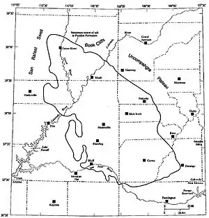
Its areal size is around 33,000 square miles (85470 km2). The combined sedimentary strata of the Paradox Basin are more than 15,000 feet (4600 m) thick in some places.[1]
Unlike most Rocky Mountain basins, the Paradox Basin is an evaporite basin containing sediments from alternating cycles of deep marine and very shallow water. As a result of the thick salt sequences and the fact that salt is ductile at relatively low temperatures and pressures, salt tectonics play a major role in the post-Pennsylvanian structural deformation within the basin.[2][3]
Natural resources
Natural resources extracted from the basin include petroleum, uranium, copper, and potash.
Much of the petroleum production in the basin has come from porous carbonate deposits, such as algal mounds, of Pennsylvanian age. Additional reservoir types include uplifted fault blocks and discontinuous clastic beds with both stratigraphic and structural traps. The principal productive horizons in the basin include the Mississippian age Leadville Limestone, the Pennsylvanian Age Hermosa Group (Honaker Trail, Paradox, and Pinkerton Trail formations) and the Permian age Cutler Formation.[4]
Discoveries in the cane creek formation have resulted in new oil production in the cane creek unit, near Moab, Utah.
See also
- Paradox Valley, which gave the basin its name
References
- Vito F. Nuccio and Steven M. Condon (1996) Burial and Thermal History of the Paradox Basin, Utah and Colorado, and Petroleum Potential of the Middle Pennsylvanian Paradox Formation, US Geological Survey, Bulletin 2000-O
- "Colorado River Basin Stratigraphy". Archived from the original on 2008-05-13. Retrieved 2008-06-11.
- Davis, Jim. "Glad You Asked: Why Does A River Run Through It? – Utah Geological Survey". Archived from the original on 2019-02-09.
- Brown, Alan Lee, 2002, OUTCROP TO SUBSURFACE STRATIGRAPHY OF THE PENNSYLVANIAN HERMOSA GROUP SOUTHERN PARADOX BASIN (PhD dissertation) "Archived copy" (PDF). Archived from the original (PDF) on 2010-07-23. Retrieved 2008-06-11.CS1 maint: archived copy as title (link) PDF file
