Paralia, Achaea
Paralia (Greek: Παραλία, Paralía, meaning "beach") is a town and a former municipality in Achaea, West Greece, Greece.
Paralia
Παραλία | |
|---|---|
 Paralia Location within the regional unit  | |
| Coordinates: 38°11′N 21°42′E | |
| Country | Greece |
| Administrative region | West Greece |
| Regional unit | Achaea |
| Municipality | Patras |
| • Municipal unit | 11.98 km2 (4.63 sq mi) |
| Elevation | 5 m (16 ft) |
| Population (2011)[1] | |
| • Municipal unit | 9,987 |
| • Municipal unit density | 830/km2 (2,200/sq mi) |
| Community | |
| • Population | 6,336 (2011) |
| Time zone | UTC+2 (EET) |
| • Summer (DST) | UTC+3 (EEST) |
| Postal code | 263 xx, 264 xx, 265 00 |
| Area code(s) | 2610 |
| Vehicle registration | ΑΧ |
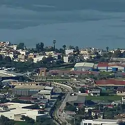
Since the 2011 local government reform it is part of the municipality Patras, of which it is a municipal unit.[2] The municipal unit has an area of 11.978 km2.[3] It is a suburb of Patras, about 6 km southwest of the city centre. The town population is about 6,500. It was a popular beach resort for residents of Patras till mid '80s. The new Greek National Road 9 (Patras - Pyrgos) runs south of the town.
The railway Patras - Pyrgos runs parallel to the coast, at about 200 m from the shore.
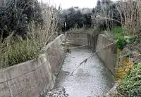
Ligias, a torrent in Paralia Patras
Panagitsa, a torrent in Paralia Patras, view from Omplos Mt.
Population history
| Year | Town population | Municipality population |
|---|---|---|
| 1981 | 2,730 | - |
| 1991 | 3,122 | 5,667 |
| 2001 | 6,124 | 9,156 |
| 2011 | 6,336 | 9,987 |
Subdivisions
The municipal unit Paralia is subdivided into the following communities:
- Mintilogli
- Paralia
- Roitika
See also
References
- "Απογραφή Πληθυσμού - Κατοικιών 2011. ΜΟΝΙΜΟΣ Πληθυσμός" (in Greek). Hellenic Statistical Authority.
- Kallikratis law Archived 2017-07-12 at the Wayback Machine Greece Ministry of Interior (in Greek)
- "Population & housing census 2001 (incl. area and average elevation)" (PDF) (in Greek). National Statistical Service of Greece.
External links
Places adjacent to Paralia, Achaea | ||||||||||
|---|---|---|---|---|---|---|---|---|---|---|
| ||||||||||
This article is issued from Wikipedia. The text is licensed under Creative Commons - Attribution - Sharealike. Additional terms may apply for the media files.