Pardesiya
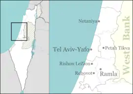
Pardesiya (Hebrew: פַּרְדֵּסִיָּה, Arabic: بردسيا) is a town in the Central District of Israel. Located on the Sharon plain, between Kfar Yona and the Lev HaSharon Regional Council, it was founded between 1937 and 1939.[2] In 2019 it had a population of 5,930;[1] its jurisdiction is 1,273 dunams (~1.3 km2)[3]
Pardesiya
| |
|---|---|
Local council (from 1952) | |
| Hebrew transcription(s) | |
| • ISO 259 | Pardesiya |
 | |
 Pardesiya  Pardesiya | |
| Coordinates: 32°18′10.03″N 34°54′39.41″E | |
| Country | |
| District | Central |
| Founded | 1938 |
| Government | |
| • Head of Municipality | Tal Gorki |
| Area | |
| • Total | 1,273 dunams (1.273 km2 or 315 acres) |
| Population (2019)[1] | |
| • Total | 5,930 |
| • Density | 4,700/km2 (12,000/sq mi) |
| Name meaning | Orchard place |
| Website | |
History

The lands of Pardesiya were purchased in 1928 by Jean-Yona Fisher, but remained unused. In 1937 Avraham Tabib of the Yemenite olim organization asked its members to come to the land to build a village, promising cheap land.[4] Twenty families came and in 1939 completed the construction. During World War II, the villagers found themselves unemployed and unable to pay taxes for their housing. The residents managed to settle the issue with the Jewish Agency for Israel and continued living in the village. After the war, a new neighborhood was built, as well as a ma'abara to absorb new immigrants. Pardesiya gained local council status in 1952.[2]
Geography and location
Pardesiya is located on the Sharon plain, bordering Kfar Yona on the east and Tzur Moshe of the Lev HaSharon Regional Council. Highway 4 borders the town to the west, and Road 5613 to the south. Its elevation is 35 m above sea level.[5]
Demographics
As of 2008, Pardesiya settles 6,318 residents.[6] 99.5% Jewish, with an additional 0.5% being other non-Arabs.[3] The age distribution was as follows:
| Age | 0 - 4 | 5 - 9 | 10 - 14 | 15 - 19 | 20 - 29 | 30 - 44 | 45 - 59 | 60 - 64 | 65 - 74 | 75+ |
|---|---|---|---|---|---|---|---|---|---|---|
| Percentage | 5.9 | 8.4 | 11.3 | 11.8 | 16.9 | 17.2 | 23.8 | 2.0 | 1.5 | 1.2 |
| Source: Israel Central Bureau of Statistics[3] | ||||||||||
References
- "Population in the Localities 2019" (XLS). Israel Central Bureau of Statistics. Retrieved 16 August 2020.
- HaReuveni, Immanuel (1999). Lexicon of the Land of Israel (in Hebrew). Miskal - Yedioth Ahronoth Books and Chemed Books. pp. 799–800. ISBN 965-448-413-7.
- "Local Authorities in Israel 2005, Publication #1295 - Municipality Profiles - Pardesiya" (PDF) (in Hebrew). Israel Central Bureau of Statistics. Retrieved 2008-05-22.
- "History of Pardesiya" (in Hebrew). Pardesiya Municipality. Archived from the original on 2010-02-20. Retrieved 2008-11-23.
- Vilnai, Ze'ev (1979). "Pardesiya". Ariel Encyclopedia (in Hebrew). Volume 7. Tel Aviv, Israel: Am Oved. p. 6132.
- "Demographic population report for 2008" (in Hebrew). Israel Central Bureau of Statistics. Retrieved 2010-04-23.