Parikino
Parikino is a settlement 24 kilometres (15 mi) upriver from Whanganui, New Zealand; the original pā site was across the Whanganui River.[1]
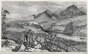
Parikino was originally a fortified settlement established in 1845 as security against a possible raid by a Ngāti Tūwharetoa taua (war party). The population of about 200 then gradually moved to the unfortified agricultural land across the river.[2] Parikino is home to the Ngāti Hinearo and Ngāti Tuera hapū of the iwi Te Āti Haunui-a-Pāpārangi.[1] The Ngāti Hinearo wharenui is called Te Aroha, and the Ngāti Tuera is Wharewhiti.[3] The meeting house Maranganui Tuarua, 3 km south of Parikino at Pungarehu,[4] was built for Ngāti Tuera by the carver Hōri Pukehika.[1]
Parikino Sports Day, consisting mainly of horseback competitions and family activities, has run every year since 1928; farm chores are traditionally put on hold for the day.[5]
One of New Zealand's most important contemporary photographers Ans Westra took a series of black-and-white photographs of children and teachers at the Parikino Maori School in 1963.[6]
There are three marae in the Parikino area. Parikino Marae and Ko Wharewhiti or Te Aroha meeting house are a meeting place for Ngāti Hinearo and Ngāti Tumango. Ātene or Kakata Marae and Te Rangi-i-heke-iho meeting house are affiliated with Ngāti Hineoneone. Pungarehu Marae and Maranganui Tuarua meeting house are affiliated with Ngāti Tuera.[7][8]
Education
Aberfeldy School is a co-educational state primary school for Year 1 to 8 students,[9] with a roll of 12 as of March 2020.[10]
References
- Beaglehole, Diana (20 March 2014). "Whanganui places: River Settlements". Te Ara: The Encyclopedia of New Zealand. Retrieved 21 November 2015.
- Walton, A. (1994). "Settlement Patterns in the Whanganui River Valley, 1839–1864" (PDF). New Zealand Journal of Archaeology. 16: 123–168.
- "Parikino Pā". Māori Maps. Archived from the original on 8 December 2015. Retrieved 21 November 2015.
- "Pungarehu". Māori Maps. Retrieved 21 November 2015.
- Hyndman, Ian (27 February 2013). "Parikino prepares to party". Wanganui Chronicle. Retrieved 21 November 2015.
- Peers, Robyn (3 October 2007). "Ans Westra: Images and Emotion". Christchurch Press. Retrieved 21 November 2015.
- "Te Kāhui Māngai directory". tkm.govt.nz. Te Puni Kōkiri.
- "Māori Maps". maorimaps.com. Te Potiki National Trust.
- "Ministry of Education School Profile". educationcounts.govt.nz. Ministry of Education.
- "Education Review Office Report". ero.govt.nz. Education Review Office.