Parish of Rooty Hill
The Parish of Rooty Hill, is a civil parish of the County of Cumberland.
.jpg.webp)
Map of the Parish of Rooty Hill, 1822.[1]
The parish is centered on the suburbs of Doonside, Mount Druitt, New South Wales and Rooty Hill, New South Wales. The boundaries of the parish are Eastern and South Creeks, and Richmond railway line on the north.
The Great Western Highway and Western Railway Line transect the parish.
The parish is one of the oldest cadasteral divisions in Australia with the administrative arrangements that would eventually become the parish existing as early as 1810. The name derives from a specific hill still known as the Rooty Hill, that is near Doonside railway station known for an abundance of roots.
view_from_Rooty_Hill-2.jpg.webp) View from the Rooty Hill, Rooty Hill, Sydney, looking across Morreau Reserve
View from the Rooty Hill, Rooty Hill, Sydney, looking across Morreau Reserve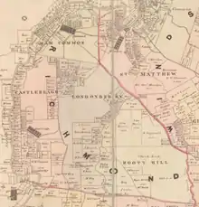 Map of the Parish in 1840.[2]
References
- PL Bemi,Map of the Parish of Gidley, 1822 (Surveyor General's Dept of New South Wales (signed) Edward Knapp LS).
- William Henry Wells, A map of the County of Cumberland in the Colony of New South Wales (William Baker, 1840).
This article is issued from Wikipedia. The text is licensed under Creative Commons - Attribution - Sharealike. Additional terms may apply for the media files.