Great Western Highway
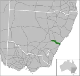
The Great Western Highway is a 201-kilometre-long (125 mi)[1][2] state highway in New South Wales, Australia. From east to west, the highway links Sydney with Bathurst, on the state's Central Tablelands.
Great Western Highway | |
|---|---|
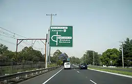 | |
Travelling westbound on the Great Western Highway at Springwood | |
 | |
| General information | |
| Type | Highway |
| Length | 201 km (125 mi)[1][2] |
| Route number(s) |
|
| Former route number | [3][4][5][6]
|
| Major junctions | |
| East end | |
| |
| West end | |
| Location(s) | |
| Major settlements | |
| Highway system | |
Route
The eastern terminus of the Great Western Highway is at Railway Square, at the intersection of Broadway with Quay Street, in the inner-city suburb of Haymarket and just south of the Sydney CBD.[7][8] From Railway Square, the Great Western Highway follows Broadway south and west. At the western end of Broadway, it branches south-west into City Road (Princes Highway). The Great Western Highway proceeds west from this junction and its local name changes to Parramatta Road and heads generally west towards Parramatta. Hume Highway (Liverpool Road) branches south-west at Summer Hill/Ashfield, and a short distance further west the majority of traffic is diverted off the highway and onto the M4 Western Motorway via the WestConnex tunnel at Ashfield. A short distance further west, still at Ashfield, the A4 arterial road ends at a major junction with the Great Western Highway (Parramatta Road) and Frederick Street (which proceeds south to join Hume Highway).
Just south of Parramatta, the highway meets Woodville Road and continues west onto an on-ramp for the M4 Western Motorway, while the highway-designated route turns sharply to the north along Church Street, before turning again at the southern fringe of the Parramatta central business district, and then continues due west across western metropolitan Sydney to Penrith, north of the central business district, where it crosses the Nepean River via the 1867 Victoria Bridge. At Leonay, the M4 Western Motorway reconnects with the Great Western Highway and the highway ascends the Blue Mountains, reaching its highest point at Mount Boyce, at an elevation of 1,093 metres (3,586 ft). It intersects at Mount Victoria with the Darling Causeway which heads north to connect with the Bells Line of Road. From Mount Victoria, the highway descends via Victoria Pass into the Hartley Valley and then passes through the western suburbs of Lithgow where it is joined by the Chifley Road, which links eastward back to the Bells Line of Road. The highway continues generally west, intersecting with the Castlereagh Highway west of Marrangaroo, and crosses Coxs River to ascend the Great Dividing Range and over the western ridge of the Sydney basin before dropping into the Macquarie Valley to reach its western terminus at Bathurst, at the junction of the Mitchell Highway and the Mid-Western Highway.[8]
At numerous points along its journey, the highway transverses or is transversed by the Main Western railway line. Major river crossings occur east of Emu Plains (Nepean), near Wallerawang (Coxs), and east of Bathurst (Macquarie).
It consists of two of Australia's most historic roads – Parramatta Road, and the full length of the former Great Western Road, from Parramatta to Bathurst.[9]
Major junctions
| LGA | Location | km[1][2] | mi | Destinations | Notes |
|---|---|---|---|---|---|
| Sydney | Haymarket | 0 | 0.0 | Broadway – Railway Square | Controlled offset four-way intersection; eastern terminus; continues southwest as |
| Chippendale | Controlled offset four-way intersection; continues east as | ||||
| Bay Street – Ultimo | no access to/from Bay Street westbound | ||||
| Hawthorne Canal | 4 | 2.5 | Battle Bridge[10] | ||
| Inner West | Summer Hill | 5 | 3.1 | Controlled Y intersection; transition south as the Hume Highway (A22); Great Western Highway / Parramatta Road continues west (no shield) | |
| Haberfield | 6 | 3.7 | Westbound access to M4 East only; Great Western Highway / Parramatta Road continues west as the A44 | ||
| 7 | 4.3 | Controlled four-way intersection; Great Western Highway / Parramatta Road continues west as the A44 | |||
| Frederick Street – Ashfield, Canterbury | Controlled four-way intersection; Great Western Highway / Parramatta Road continues west as the A44 | ||||
| Iron Cove Creek | 7 | 4.3 | Bridge over the creek (bridge name unknown) | ||
| Strathfield | Strathfield | 10 | 6.2 | Controlled T intersection; incomplete access from M4 to Great Western Highway westbound | |
| Homebush | 13 | 8.1 | M5 Motorway and Hurstville, Sydney Olympic Park, Ryde, Macquarie Park, Pymble | ||
| Haslams Creek | 15 | 9.3 | Haslams Creek Bridge[11] | ||
| Cumberland | Lidcombe | 16 | 9.9 | ||
| Duck River | 18 | 11 | Bridge over the river (bridge name unknown) | ||
| Parramatta | Clyde | 18 | 11 | James Ruse Drive (no shield) – Rosehill to | Controlled four-way intersection; incomplete access to/from Berry Street |
| Duck Creek | 19 | 12 | Duck Creek Bridge[12] | ||
| Parramatta | Granville | 20 | 12 | Woodville Road – Merrylands | Controlled four-way intersection; Great Western Highway / Church Street continues north as A44 |
| Parramatta | 21 | 13 | Church Street (no access northbound); Parkes Street (no access north-eastbound); | Controlled four-way intersection; Great Western Highway continues westbound as A44 | |
| O'Connell Street (no access northbound) | Controlled T intersection; Great Western Highway continues westbound as A44 | ||||
| Pitt Street (access to north) – Parramatta, Windsor; | Controlled four-way intersection; Great Western Highway continues westbound as A44 | ||||
| Cumberland | South Wentworthville | 23 | 14 | Coleman Street – Merrylands | |
| Entrance ramp to | Eastbound access to M4 only | ||||
| Wentworthville | 24 | 15 | to | ||
| Prospect | 29 | 18 | Prospect Highway – Wetherill Park, Blacktown, Baulkham Hills | Uncontrolled interchange (no access to Great Western Highway westbound from the Prospect Highway) | |
| Eastern Creek | 34 | 21 | Bridge over the creek (bridge name unknown) | ||
| Blacktown | Eastern Creek | 35 | 22 | No access to M7 southbound | |
| Wallgrove Road to Light Horse Interchange to Rooty Hill Road – Rooty Hill | |||||
| Ropes Creek | 40 | 25 | Bridge over the creek (bridge name unknown) | ||
| South Creek / Wianamatta | 44 | 27 | South Creek Bridge[13] | ||
| Penrith | Kingswood | 49 | 30 | ||
| Penrith | 51 | 32 | Castlereagh Road – Castlereagh, Richmond, Windsor | Great Western Highway (A44) continues southbound | |
| Mulgoa Road – Glenmore Park, Mulgoa to | Great Western Highway (A44) continues westbound | ||||
| Peach Tree Creek | 51 | 32 | Peach Tree Creek Bridge[14] | ||
| Nepean River | 52 | 32 | Victoria Bridge[15] | ||
| Penrith | Emu Plains | 56 | 35 | Uncontrolled dumbbell interchange; A44 western terminus; Great Western Highway transitions west as the | |
| Glenbrook | 57 | 35 | M4 transitions west as the | ||
| Blue Mountains | Springwood | 69 | 43 | Macquarie Road – Springwood, Winmalee, Richmond | Westbound access to Macquarie Road only |
| 70 | 43 | Hawkesbury Road – Springwood, Winmalee, Richmond | Eastbound access to and from Hawkesbury Road only | ||
| 71 | 44 | Ferguson Road – Springwood, Winmalee, Richmond | Westbound access from Ferguson Road only | ||
| Wentworth Falls | 96 | 60 | Scott Avenue – Leura | Scenic Drive | |
| Leura | 98 | 61 | Leura Mall – Leura | Roundabout interchange | |
| Katoomba | 100 | 62 | Yeaman Bridge Road – Katoomba, The Three Sisters | ||
| 102 | 63 | Bathurst Road – Katoomba, The Three Sisters | Eastbound access to Bathurst Road only; Scenic Drive | ||
| Mount Victoria | 117 | 73 | Darling Causeway – Bell to the | ||
| Lithgow | Hartley | 128 | 80 | Jenolan Caves Road – Oberon, Jenolan Caves | |
| Bowenfels | 135 | 84 | Magpie Hollow Road – Lake Lyell, Rydal, O'Connell | ||
| 138 | 86 | to the | |||
| Marrangaroo Creek | 145 | 90 | Marrangaroo Creek Bridge[16] | ||
| Lithgow | Marrangaroo | 146 | 91 | ||
| Coxs River | 148 | 92 | Jack Wilson Bridge | ||
| Lithgow | Wallerawang | 148 | 92 | Barton Avenue – Wallerawang, Wallerawang Power Station | |
| Bathurst Regional | Kelso | 195 | 121 | Littlebourne Street to O'Connell Road – O'Connell, Oberon, Goulburn | |
| 196 | 122 | Gilmour Street – Sofala, Ilford, Mudgee | |||
| Macquarie River | 197 | 122 | Evans Bridge | ||
| Bathurst | Bathurst | 201 | 125 | Roundabout; western terminus of the Great Western Highway; Road transitions to the Mitchell Highway (A32) | |
1.000 mi = 1.609 km; 1.000 km = 0.621 mi
| |||||
History
Sydney CBD to Parramatta and Penrith
Initial travel between Sydney and the settlement of Parramatta was by water along the Parramatta River. Sometime between 1789 and 1791 an overland track was made to provide an official land route between the two settlements.[17] Parramatta Road dates to the 1792 formation of a route linking Sydney to the settlement of Parramatta, formalised under the direction of Surveyor-General Augustus Alt in 1797. Parramatta Road became one of the colony's most important early roadways, and for many years remained one of Sydney's premier thoroughfares.[18] By 1810, Parramatta Road had officially open to traffic and was financed during a large portion of the 1800s by a toll, with toll booths located at what now is Sydney University and the Duck River.[8]
From Parramatta to Penrith, a road along the current alignment of the Great Western Highway (except at Prospect and Penrith) was constructed soon after completion of the Sydney-Parramatta Road.[8]
Emu Plains to Mount Victoria
In 1813, acting on the instructions of Governor of New South Wales Lachlan Macquarie, Gregory Blaxland, William Lawson and William Wentworth led an 1813 expedition that travelled west from Emu Plains and, by staying to the ridges, were able to confirm the existence of a passable route directly west from Sydney across the Blue Mountains. The existence of other, less direct routes had been known as far back as 1797, but due to the need to prevent convicts from believing that escape from the hemmed-in Sydney region was possible, knowledge of the expeditions confirming the existence of routes across the Blue Mountains was suppressed. Blaxland, Lawson and Wentworth travelled as far west as the point they named Mount Blaxland, 25 kilometres (16 mi) southwest of where Lithgow now stands. From this point they were able to see that the worst of the almost impenetrable terrain of the Blue Mountains was behind them, and that there were easy routes available to reach the rolling countryside they could see off to the west.
Mount Victoria to Bathurst
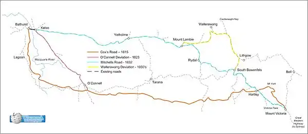
Macquarie then despatched Surveyor George Evans to follow Blaxland, Lawson and Wentworth's route and to push further west until he reached arable land. Evans travelled west until he reached the Fish River, and followed it downstream until he reached the site of Bathurst. Within a year, Macquarie commissioned William Cox to construct a road west from Emu Plains, following Evans' route, and this road was finished in 1815. Macquarie himself travelled across it soon after completion, established and named Bathurst, and named the road the Great Western Road.
The section of the Great Western Road as far west as Mount Victoria, with a small number of minor deviations, is still in use today as part of the Great Western Highway. West of Mount Victoria, Evans' route has been superseded, chiefly by Mitchell's new route constructed between 1832 and 1836.
Route development
Between present-day Flemington and Dogtrap Road (now Woodville Road), Parramatta Road travelled in a wide arc some 2 kilometres (1.2 mi) south of the present route, to avoid marshy areas around Haslams Creek and the Duck River. This was deviated in the 1920s to follow the present route.
At Mount Victoria, at the western edge of the Blue Mountains, the route of Cox's road turned north to Mount York, from where it descended into the Hartley Valley. This pass was the major piece of engineering on the original route, and when Macquarie travelled the new road in 1815, he named it Cox's Pass in honour of the builder. From the foot of Mount York the road resumed its westerly direction to where Hartley now stands. However, from here it ran via the present-day Glenroy, Mount Blaxland, Cut Hill Road, Pitts Corner, Phils Falls, Mount Olive Rd, Carlwood Road and Sidmouth Valley to a point 2 kilometres (1.2 mi) south of O'Connell. From here it continued westward, not crossing the Fish River, but crossing Campbells River 1,500 metres (4,900 ft) north of the present bridge at The Lagoon and ascending to another ridgeline where it turned north to Gormans Hill, to reach the future site of Bathurst from the south, not the east.
For the first one hundred years after this ceased to be the route of the Great Western Road it remained trafficable, but the destruction of the bridge at Phil's Falls on the Fish River in 1930 meant it was no longer a through route, and parts became untrafficable. However, most of this route remains in existence as a series of local roads.
The original route had only been in existence for eight years when, in 1823, Assistant Surveyor James McBrian identified an improved route on the approaches to Bathurst. This route turned north 2 kilometres (1.2 mi) south of O'Connell to run northwest to where Kelso is now located, then west across the Macquarie River into Bathurst. The section from south of O'Connell to Kelso is now part of the Bathurst-Oberon Road, and from Kelso into central Bathurst still remains as part of the Great Western Highway.
When Major Thomas Mitchell was appointed as Surveyor-General in 1828, one of the first matters to which he turned his attention was the improvement of the Great Western Road. Mitchell's attention was focussed on providing a more direct and easily graded route for the Great Western Road. To this end, he surveyed a route running northwest from Hartley via Mt Walker to Meadow Flat, crossing the Great Dividing Range at Mount Lambie, then running in an almost straight line westward via Browns Hill to Kelso, to meet the pre-existing road. This road remains in existence – from Mount Lambie west it remains as the route of the current Highway (with deviations) but the section adjacent to Cox's River was inundated by the construction of Lake Lyell for Wallerawang Power Station in the late 1970s.
Mitchell was also concerned to improve the worst sections of the road, which were the climb from the Cumberland Plain, on which Sydney sits, and the descent of Mount York, down the western side of the Blue Mountains.
In improving the eastern ascent Mitchell adhered largely to Cox's route, which follows the southern side of an east-falling gully to reach the plateau at where Blaxland is now located. However, he engaged Scottish engineer David Lennox to build a stone arch bridge, now the Lennox Bridge, across the mouth of a particularly deep side gully. This route, known as Mitchell's Pass, was completed in 1833 and superseded what is now called Old Bathurst Road, located to the north of the route. The Mitchell's Pass and Lennox Bridge served as the main route to the Blue Mountains for 93 years until 1926, when the Great Western Highway was re-routed via sections of the former Lapstone Zig Zag including the Knapsack Viaduct.[19]
After protracted arguments first with Governor Ralph Darling and then his successor Richard Bourke, and ignoring orders, Mitchell surveyed, designed and had built what is now known as Victoria Pass, where the highway drops from the Blue Mountains into the Hartley Valley. Midway down the road had to be supported on a causeway formed by massive stone buttressed walls, where a narrow ridge connects two large bluffs. This ridge had to be widened and raised to give the highway a route from the upper to the lower bluff. Mitchell cut terraces into the sides of these bluffs to form a passage for the road. It is a testimony of Mitchell's vision and engineering skill that this route, almost unchanged, and using his 1832 stonework, is still in use. Because this pass brought the road into the Hartley Valley several kilometres south of the Mount York descent, it necessitated a new route as far west as Hartley to meet Cox's Road. This also is still in use as part of the highway.
In 1929 the Main Roads Board deviated the route north from Old Bowenfels to Marrangaroo, using trunk road 55 (Mudgee Road). From Marrangaroo a new road was built westward, running south of Wallerawang to meet Mitchell's 1830 deviation immediately east of Mount Lambie. This route avoids the long, steep gradients either side of Cox's River, which were the main drawback of Mitchell's route.
The Great Western Highway today therefore consists of Parramatta Road to Parramatta, the Great Western Road to Emu Plains, Coxs Road to Hartley (other than Mitchell's deviations at Lapstone and Mount York), Mitchell's route from Hartley to Old Bowenfels, the Main Roads Board route from Old Bowenfels to Mount Lambie, Mitchell's road from Mount Lambie to Kelso, and McBrian's road from Kelso to central Bathurst.
Great_Western_Highway_Blaxland.jpg.webp)
Improvements
Early improvements
The first recorded major improvement to the route of the Great Western Highway was the construction in 1806 of ten bridges along Parramatta Road.
In attempts to improve the gradient of the descent from the Blue Mountains plateau to the floor of the Hartley Valley, Lawson's Long Alley was opened in 1824. This still did not prove satisfactory and construction of a second deviation, known as Lockyer's Pass, was commenced. However this route was not completed, as its construction was abandoned in favour of construction of Mitchell's route via Victoria Pass.
Originally the Great Western Road crossed the Nepean River at Penrith by means of a ferry adjacent to the Log Cabin Hotel. This was superseded in 1856 by a bridge which was destroyed by a flood in 1857. A second bridge was opened in 1860, and was destroyed by the record flood of 1867. In the same year a new bridge, Victoria Bridge, was nearing completion adjacent to the road crossing, as part of the Penrith-Weatherboard (Wentworth Falls) section of the Main Western Railway. Its deck was modified to accommodate road traffic as well as the single-track railway. This bridge continued in dual use until 1907 when the current steel truss railway bridge was built alongside, and the 1867 bridge was given over solely to road traffic. This bridge remains in use for the Great Western Highway. The design of this bridge is almost identical to that of the 1863 Menangle Railway Bridge, also over the Nepean River.
In 1870 the Denison Bridge, a wrought iron truss bridge, was built across the Macquarie River at Bathurst.[20] This replaced an earlier wooden bridge.[21]
Early 20th Century improvements
In the first few years of the 20th century the railway overpasses between Lapstone Hill and Mount Victoria were replaced as part of the duplication of the Main Western railway. These bridges were of brick arch construction. They were in turn replaced in the mid-1950s to obtain the necessary height clearances for overhead wiring for the electrification of the Main Western Railway from Penrith to Bowenfels.
In 1912 Victoria Pass was superseded by Berghofers Pass, which followed a similar route to Victoria Pass, but below it. It was more winding and thus longer, thereby affording a less steep climb. However rapid improvements in motor vehicle performance meant that in 1920 Victoria Pass was rebuilt to become the main route again.
After the ascent of the eastern escarpment by the Main Western Railway was deviated for the second time in 1913 to its current route via Glenbrook Gorge, the Great Western Road was also deviated at this point for a second time in 1926 by the then Main Roads Board, which rerouted it via the disused 1867 stone arch railway viaduct across Knapsack Gully and around the southern side of Lapstone Hill to gain the first plateau in the ascent of the Blue Mountains. As this viaduct had held only a single railway track, its deck was widened in 1939 to its present two lane configuration. The viaduct was closed to motor traffic when the M4 motorway was extended west from Russell Street to connect to the Highway at Lapstone in 1994.
West of Knapsack Gully, although now widened to four lanes, the 1926 route of the highway is still in use. It uses a long stretch of abandoned railway formation – the section from Zig Zag Street to Blaxland station is located on the original 1867 railway alignment. An indication of the need to divert the railway can be gained from the gradient of the highway as it climbs west from Hare St to Lovett Street.
A number of deviations were built in 1929:
- at Haslams Creek, Lidcombe, to straighten the road and provide a new bridge[22]
- between Warrimoo and Valley Heights, to remove an underpass and an overpass of the railway from the route of the highway
- at Eusdale, Yetholme (in three sections) and Melrose (all west of Meadow Flat), to ease gradients.
In 1930 the level crossing at Bowenfels was replaced by an underpass.
Victoria Pass was upgraded in 1932 to give a constant width of 8.5 m, with a minor deviation built at the foot of the pass.
Upgrading since World War II
In 1957 a short deviation immediately west of Linden eliminated two narrow overpasses of the railway, both of which had right angle bend approaches from both directions. These bridges would have had to have been replaced in any event to allow for overhead wiring for the electrification to Bowenfels of the Main Western Railway. Such replacements occurred east of Linden, further west of Linden near Bull's Camp, east of Lawson, at Medlow Bath and east of Mount Victoria, and in these cases the replacement bridges were located at a skew angle to eliminate right angle bend approaches, with the earlier bridges left for pedestrian use.
In 1958 the 'Forty Bends’, where the Highway runs along the foot of Hassans Walls approaching Lithgow, were eased. The fact that this section of the Highway is on the southern side of a very high escarpment poses severe ice problems during winter, due to the lack of sunlight.
In the early 1960s the highway was deviated east of Leura to cross under the railway at Scott Parade (which was itself part of the former highway route) and run along the north side of the railway to rejoin the previous route at Leura Mall.
In 1967, the highway was deviated to bypass Springwood shopping centre, eliminating two narrow underpasses of the railway from the highway route. The previous route remain in use for local traffic as Macquarie Road. In 1968 a dual carriageway 3 km deviation was opened at Prospect. This replaced the only winding section of the Highway between Parramatta and Penrith. The bypassed section was heritage-listed in 2014 as the best-preserved section of the 1818 alignment.[23]
From the late 1960s to the early 1970s the highway was almost entirely realigned and constructed to three lanes, being deviated as necessary, between Kirkconnell and Glanmire. Ironically this included reinstatement of most of the parts of Major Mitchell's 1830 alignment which had been deviated in 1929 to ease gradients.
This work was extended eastward to Mount Lambie in stages during the late 1980s and early 1990s. A second Cox's River deviation, to replace the 1929 deviation, was completed in 1993, between Marrangaroo and Mount Lambie.
At Katoomba the highway was deviated in 1985 to travel along the eastern side of the railway station, whereas the original alignment crossed the railway via a level crossing at the north end of Katoomba Street and ran along the western side of the railway. Immediately west of where the highway now crosses the railway due to this deviation, the highway was realigned over a distance of 1 km in 2004 to remove the sharp bend at 'Shell Corner'.
In Bathurst, the Denison Bridge (1870) was bypassed in 1991 by a realignment of the Highway where it crosses the Macquarie River into Bathurst city centre. Because of its heritage value it was retained for use by cyclists and pedestrians.
During 1991–1993 a massive cutting was made to improve and widen the alignment of the highway immediately east of Woodford. At the top of the southern side of this cutting can be seen the rudimentary excavation of the rock for Cox's 1815 road. This was severed in 1868 by the construction of the Springwood-Mount Victoria section of the Main Western Railway. The railway itself was deviated at this point in the 1920s when it was duplicated, and a cutting on the original alignment of the railway now forms the top section of the southern face of the highway cutting, the terrace in the face of the cutting being the bed of the original cutting.
In June 1993 the highway route was severed at Emu Plains with the closure to road traffic of the Knapsack Gully Viaduct. This occurred in conjunction with the westward extension of the M4 motorway from its terminus since 1971 at Russell Street, Emu Plains. This extension connects directly to the highway at Lapstone, bypassing the viaduct. The portion of the Great Western Highway west from Russell Street to Mitchells Pass Road is now only used by local traffic to access residential properties. Mitchells Pass, travelling is now one way eastbound between Lennox Bridge and the highway, due to its narrowness. Great Western Highway traffic therefore has to use the M4 between Russell St and Governors Drive.
A major realignment west from Mount Boyce (the highest point on the highway) to eliminate the Soldiers Pinch and other nearby sharp curves was completed in 2002.
Duplication and widening
From Railway Square to Woodville Road, the highway was widened to its present width when it was reconstructed in reinforced concrete in the 1930s. From Woodville Road west to The Northern Road the highway was widened, generally progressively westward, from the mid-1960s to the late 1970s. This section is a combination of six lanes with median strip, six lanes with wide landscaped median, and four lanes undivided. At The Northern Road in Kingswood the highway reverts to a four lane undivided configuration through Penrith shopping centre, widens to six lanes at the Castlereagh Road intersection, reverts to two lanes west from Castlereagh Road to Russell Street, and is then four lanes undivided with sealed shoulders from Russell Street to the base of Mitchells Pass, where it has been truncated.
Between 1981 and 2015 the NSW Government Roads & Maritime Services duplicated the highway between Leonay and 1 kilometre (0.62 mi) west of Katoomba, generally working westward.[24] This work incorporated the dual carriageway Springwood bypass, opened in 1967.
West of Katoomba, there is a further 1 kilometre (0.62 mi) of dual carriageway on the River Lett Hill, and 16 kilometres (9.9 mi) of dual carriageway from Magpie Hollow Road at Old Bowenfels to Lidsdale State Forest. This was completed as follows:
- Lawson road widening and realignment – completed in 2006[9]
- River Lett Hill – 2014/15
- Old Bowenfels to Bowenfels – completed in sections during the late 1990s
- Bowenfels to Marrangaroo Creek – mid-1970s
- Marrangaroo interchange with the Castlereagh Highway – 1970
- Marrangaroo interchange to Lidsdale State Forest (second Cox's River deviation) – 1993.
Four-lane undivided sections are the 2.5-kilometre (1.6 mi) of Victoria Pass (except for Mitchell's 1832 causeway, which is two lanes), and from Boyd Street in Kelso to the terminus of the highway at its junction with the Mitchell and Mid Western Highways in West Bathurst (parts have a raised median strip).
From Lidsdale State Forest as far west as Glanmire most of the highway is three lanes, with almost continuous overtaking lanes alternating between eastbound and westbound.
Current projects
- Repairs and enhancements from Victoria Pass to Lithgow. The bridge at Victoria Pass is being refurbished and kept as two lane (one each direction.)
- Forty Bends upgrade (from top of River Lett Hill to Magpie Hollow Road) – consists of extension of the length of three-lane pavement and measures to reduce the incidence of black ice in winter
- Duplication from Ashworth Drive to Stockland Drive Kelso (in Bathurst).[24]
Route numbers
When the national route numbering system was introduced in 1954, the full length of the Great Western Highway was designated as part of national route 32 (Sydney-Adelaide via Dubbo and Broken Hill), with the section from City Road to the Hume Highway (Liverpool Road) Summer Hill also being part of national route 31.
Current numbering is extremely confusing, as follows:
- City Road to Hume Highway (Liverpool Road) Ashfield – A22, following the introduction of the 'Metroads' in the late 1990s. Before M5 East was opened in late 2001 it was Metroad 5. After 2001 it was State Route 31.
- Liverpool Road, Ashfield to Wattle Street, Haberfield – no route number since the diversion via Stage 3, City-West Link on 2 June 2000.
- Wattle Street, Haberfield to M4 Western Motorway intersection at Strathfield – A44, following the opening of M4 East in July 2019. Before this, it was part of the A4.
- M4 Western Motorway intersection at Strathfield to Russell Street, Emu Plains – A44.
- Russell Street-M4 at Lapstone (Knapsack Viaduct now closed) – no number.
- M4 at Lapstone to intersection of Mitchell and Mid Western Highways in Bathurst (end of Great Western Highway) – A32.
The A32 continues along the Mitchell Highway as far as Nyngan, then follows the Barrier Highway to Gawler, 25 kilometres (16 mi) north of Adelaide, where it connects with the Sturt Highway (A20). The Mid Western Highway is A41 or B64 over its full length of Bathurst to Hay, where it meets the Sturt Highway (A20) and Cobb Highway (B75).
Route number changes
Before the North Strathfield-Mays Hill and Huntingwood-Emu Plains sections of the then Western Freeway were joined by the construction of the missing link from Mays Hill to Huntingwood, the section of the highway between Reservoir Road, Huntingwood and Russell Street, Emu Plains was signposted as national route 32. When Metroads were introduced, the highway east of North Strathfield and the full length of the Freeway were designated as Metroad 4. The section of highway from Wattle St to the Liverpool Rd became unnumbered following the opening of the final stage of the City-West Link, so that Metroad 4 commenced under freeway conditions at Anzac Bridge, joining the Harbour Bridge and Cross-City Tunnel.
From the introduction of the Metroads until the opening of the M5 East (General Holmes Drive to King Georges Road) in 2001, the part of the highway between Railway Square and the Hume Highway was designated as part of Metroad 5. When the M5 East was completed, the Metroad 5 designation was assigned to the freeway; those parts of the highways (both Great Western/Hume Highway) which had been part of Metroad 5 were then given over to a logical continuation of State Route 31 east beyond Metroad 3, which is now designated A22. From North Strathfield to Russell Street, Emu Plains the highway is now A44 (as is the section of Russell Street from the Highway to the M4).
When M4 East opened between Strathfield and Haberfield in July 2019, the M4 designation was rerouted onto the new motorway. As a result, the section of Great Western Highway/Parramatta Road between Strathfield and Haberfield was designated A44, replacing the previous A4 designation.
Route names
From Sydney to Blue Mountains:
- Broadway
- Parramatta Road (officially renamed Great Western Highway in 1928)
- Church Street (officially renamed Great Western Highway in 1928)
- Great Western Highway
- Henry Street
- High Street
- Great Western Highway
- Russell Street
- Great Western Highway
References
- "Great Western Hwy, Glebe NSW 2037 to Leonay, New South Wales 2750". Google Maps. Google Inc. 2020. Retrieved 15 December 2020.
- "Great Western Hwy, Glenbrook NSW 2773 to 328 A32, Bathurst NSW 2795". Google Maps. Google Inc. 2020. Retrieved 15 December 2020.
- "National Route 32". OZROADS: The Australian Roads Website. 2013. Retrieved 1 June 2013.
- "National Routes". OZROADS: The Australian Roads Website. 2013. Retrieved 1 June 2013.
- "Metroad 4". OZROADS: The Australian Roads Website. 2013. Retrieved 1 June 2013.
- "Metroad 5". OZROADS: The Australian Roads Website. 2013. Retrieved 1 June 2013.
- Roads and Martime Services, NSW Government. Schedule of Classified Roads and Unclassified Regional Roads. April 2017
- "Great Western Highway – History and Development". OZROADS: The Australian Roads Website. Retrieved 7 October 2013.
- "Great Western Highway: Heritage". Roads & Maritime Services. Government of New South Wales. Archived from the original on 26 October 2016. Retrieved 25 October 2016.
- "Battle Bridge over Hawthorne Canal". NSW State Heritage Inventory. Government of New South Wales: Office of Environment & Heritage. 29 October 2004. Retrieved 15 May 2019.
- "Haslams Creek Bridge". NSW State Heritage Register. Government of New South Wales: Office of Environment & Heritage. 17 April 2009. Retrieved 15 May 2019.
- "Duck Creek Bridge". NSW State Heritage Register. Government of New South Wales: Office of Environment & Heritage. 25 June 2008. Retrieved 15 May 2019.
- "South Creek Bridge (eastbound)". NSW State Heritage Register. Government of New South Wales: Office of Environment & Heritage. 17 April 2009. Retrieved 15 May 2019.
- "Peach Tree Creek Bridge". NSW State Heritage Inventory. Government of New South Wales: Office of Environment & Heritage. 22 October 2003. Retrieved 15 May 2019.
- "Victoria Bridge". NSW State Heritage Register. Government of New South Wales: Office of Environment & Heritage. 18 March 2015. Retrieved 15 May 2019.
- "Marrangaroo Creek Bridge". NSW State Heritage Register. Government of New South Wales: Office of Environment & Heritage. 17 April 2009. Retrieved 15 May 2019.
- Broomham, Rosemary (2001), Vital connections: a history of NSW roads from 1788, Hale & Iremonger in association with the Roads and Traffic Authority NSW, p. 25, ISBN 978-0-86806-703-2
- "Sandstone Kerb – Parramatta Road". State Heritage Register. Office of Environment and Heritage, Government of New South Wales. 2005. Retrieved 7 October 2013.
- "Lennox Bridge, Mitchell's Pass, Lapstone Hill". Blue Mountains, Australia, History. David Martin. 2003. Retrieved 7 October 2013.
- "Denison Bridge (Place ID 15953)". Australian Heritage Database. Department of the Environment.
- "Denison Bridge washed away". The Maitland Mercury & Hunter River General Advertiser. 2 June 1867. Retrieved 9 March 2011.
- "Haslams Creek Bridge". NSW Government: Transport: Roads & Maritime Services. 3 November 2001. Retrieved 4 September 2011.
- "Former Great Western Road, Prospect". New South Wales State Heritage Register. Office of Environment and Heritage. H01911. Retrieved 18 June 2018.
- "Great Western Highway upgrade". Roads & Maritime Services. Government of New South Wales. Retrieved 25 October 2016.