Park Hill, Oklahoma
Park Hill is an unincorporated community and census-designated place (CDP) in southwestern Cherokee County, Oklahoma, United States.[2] The population was 3,909 at the 2010 census.[3] It lies near Tahlequah, east of the junction of U.S. Route 62 and State Highway 82.
Park Hill, Oklahoma | |
|---|---|
 Park Hill post office in March 18, 2010 | |
 Location within Cherokee County and the state of Oklahoma | |
| Coordinates: 35°51′49″N 94°56′52″W | |
| Country | United States |
| State | Oklahoma |
| County | Cherokee |
| Area | |
| • Total | 34.9 sq mi (90.4 km2) |
| • Land | 34.4 sq mi (89.1 km2) |
| • Water | 0.5 sq mi (1.3 km2) |
| Elevation | 748 ft (228 m) |
| Population (2010) | |
| • Total | 3,909 |
| • Density | 114/sq mi (43.9/km2) |
| Time zone | UTC-6 (Central (CST)) |
| • Summer (DST) | UTC-5 (CDT) |
| ZIP code | 74451 |
| Area code(s) | 539/918 |
| FIPS code | 40-57300[1] |
| GNIS feature ID | U.S. Geological Survey Geographic Names Information System: Park Hill, Oklahoma |
Founded in 1838, Park Hill became the home of many important Cherokee leaders, including John Ross after their removal from the southeastern U.S. It has been called "the center of Cherokee culture."
History
Park Hill was a pre-established hamlet that became the home for many of the Cherokee after coming from the East on the "Trail of Tears". In 1829 the Park Hill Mission was established.[4] The mission had one of the earliest presses in Oklahoma, the Park Hill Mission Press. The first post office was established at Park Hill on May 18, 1838.[4] It was in Park Hill that Chief John Ross made his home in 1839,[5] as well as his nephew-in-law George Murrell, whose home still stands.[5] On May 6, 1847, the post office was moved to Tahlequah.[4] The Cherokee Female Seminary was built here in 1849.[5]
Park Hill was the center of culture for the Cherokees for many years,[4] and as such in 1940 the National Society of the Colonial Dames of America in Oklahoma erected a marker at Park Hill declaring it the "Center of Cherokee culture".
The post office at Park Hill was re-established April 22, 1892.[4]
In and around Park Hill are several important sites listed on the National Register of Historic Places, including the Murrell Home, the Park Hill Mission Cemetery (also known as the Worcester cemetery),[6] the Ross Cemetery, and the original Cherokee Female Seminary. The Cherokee Heritage Center in Park Hill, was built on the former grounds of the Female Seminary. The Echota Ceremonial Ground has been located in Park Hill since 2001, on the north side of town.[7][8]
Park Hill Mission, which antedated the community, was founded in 1829. The first person buried in Park Hill Mission Cemetery was Elias Boudinot, founder of the Cherokee Phoenix newspaper, who was assassinated in Park Hill on June 23, 1839. Samuel Worcester and his two wives were also interred here. The last burial in this cemetery was a Worcester daughter, Ann Eliza Worcester Robertson. in 1905. This cemetery was listed on the National Register of Historic Places on December 6, 2006.[6]
Geography

Park Hill is located south of the center of Cherokee County at 35°51′49″N 94°56′52″W (35.863727, -94.947829).[9] It is bordered to the north by Tahlequah, the county seat. U.S. Route 62 leads north to Tahlequah and southwest 25 miles (40 km) to Muskogee, while Oklahoma State Highway 82 leads south 31 miles (50 km) to Vian.
According to the United States Census Bureau, the Park Hills CDP has a total area of 34.9 square miles (90.4 km2), of which 34.4 square miles (89.1 km2) is land and 0.50 square miles (1.3 km2), or 1.48%, is water.[3]
Demographics
As of the census[10] of 2010, there were 3,909 people, 1,260 households, and 986 families residing in the CDP. The population density was 113.3 people per square mile (43.7/km2). There were 1,437 housing units at an average density of 41.6/sq mi (16.1/km2). The racial makeup of the CDP was 43.4% White, 1.3% African American, 40.3% Native American, 0.1% Asian, 4% from other races, and 10.8% from two or more races. Hispanic or Latino of any race were 6.9% of the population.
There were 1,254 households, out of which 47.6% had children under the age of 18 living with them, 56.4% were married couples living together, 20.3% had a female householder with no husband present, and 19.1% were non-families. 15.6% of all households were made up of individuals, and 5.6% had someone living alone who was 65 years of age or older. The average household size was 2.95 and the average family size was 3.28.
In the CDP, the population was spread out, with 30.8% under the age of 18, 14.1% from 18 to 24, 23.0% from 25 to 44, 21.8% from 45 to 64, and 10.2% who were 65 years of age or older. The median age was 28.8 years. For every 100 females, there were 96.2 males. For every 100 females age 18 and over, there were 93.8 males.[11]
The median income for a household in the CDP was $40,135, and the median income for a family was $37,299. Males had a median income of $32,308 versus $29,125 for females. The per capita income for the CDP was $11,816. About 37.8% of families and 40.8% of the population were below the poverty line, including 64.0% of those under age 18 and 13.4% of those age 65 or over.[12]
Education
Sequoyah High School is in Park Hill CDP.[13][14]
Notable people from Park Hill
- Elias Boudinot (1802-1839), editor of Cherokee Phoenix, assassinated in Park Hill
- Elias Cornelius Boudinot (1835-1890), son of Elias Boudinot, lived in Park Hill until his father's death
- Alice Brown Davis (1852–1935), Principal Chief of the Seminole Nation of Oklahoma
- John Ross (1790-1866), Principal Chief of the Cherokee Nation
- Mary G. Ross (1908-2008), the first Native American female engineer
- Tommy Wildcat (b. May 3, 1967), Native American flutist, storyteller, lecturer, and traditionalist
- Samuel Worcester (1798–1859), missionary to the Cherokee, translator of the Bible, printer and defender of Cherokee sovereignty. Lived, died, and was buried in Park Hill.
Gallery
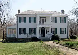
Murrell Home, built 1844-5 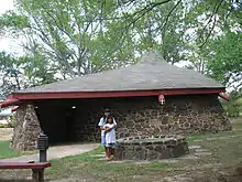
Ho-Chee-Nee Chapel at the Cherokee Heritage Center 
Tender Mercies Baptist Church
References
- "U.S. Census website". United States Census Bureau. Retrieved 2008-01-31.
- U.S. Geological Survey Geographic Names Information System: Park Hill, Oklahoma
- "Geographic Identifiers: 2010 Demographic Profile Data (G001): Park Hill CDP, Oklahoma". U.S. Census Bureau, American Factfinder. Archived from the original on February 18, 2015. Retrieved February 18, 2015.
- Shirk, George (1987). Oklahoma Place Names. Norman, Oklahoma, United States of America: University of Oklahoma Press. p. 288. ISBN 9780806120287.
- Morris, John (1977). Ghost Towns of Oklahoma. Norman, Oklahoma: University of Oklahoma Press. p. 229. ISBN 9780806114200.
- [United States Department of the Interior. National Park Service. "Park Hill Mission Cemetery - National Register of Historic Places Registration Form." December 6, 2006. Accessed March 4, 2016]
- Chavez, Will (2015-01-17). "Echota Ceremonial Ground has long history in area". Cherokee Phoenix (in English and Cherokee). Retrieved 2015-09-27.
- Murphy, Jami (2015-02-17). "Stomp dance raises money for Cherokee family". Cherokee Phoenix (in English and Cherokee). Retrieved 2015-09-27.
- "US Gazetteer files: 2010, 2000, and 1990". United States Census Bureau. 2011-02-12. Retrieved 2011-04-23.
- "2010 U.S. Census: Profile of General Population and Housing". Archived from the original on 2020-02-12. Retrieved 2012-12-09.
- "2010 U.S. Census: Age Groups and Sex". Archived from the original on 2020-02-12. Retrieved 2012-12-09.
- "American Community Survey 2006-2010 5-Year Estimates: Selected Economic Characteristics". Archived from the original on 2020-02-12. Retrieved 2012-12-09.
- "2010 CENSUS - CENSUS BLOCK MAP: Park Hill CDP, OK" (PDF). U.S. Census. Retrieved 2020-10-12. - The land with Sequoyah HS is on page 3.
2000 Map: "CENSUS 2000 BLOCK MAP: PARK HILL CDP" (PDF). U.S. Census Bureau. Retrieved 2020-10-12. - page 3 - "Home". Sequoyah High School. Retrieved 2020-10-12.
17091 S. Muskogee Ave.Tahlequah, OK 74465
- Compare the address to the CDP maps.
Further reading
- Editors. "Historical Notes". Chronicles of Oklahoma 19:1 (March 1941) 99-103. (accessed March 8, 2007)
- Shirk, George H. Oklahoma Place Names. Norman: University of Oklahoma Press, 1987. ISBN 0-8061-2028-2 .
- Wright, Murial. "Notes of the Life of Mrs. Hannah Worcester Hicks Hitchcock and the Park Hill Press". Chronicles of Oklahoma 19:4 (December 1941) 348–355. (accessed March 8, 2007)
Municipalities and communities of Cherokee County, Oklahoma, United States | ||
|---|---|---|
| City | 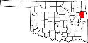 Cherokee County map | |
| Towns | ||
| CDPs | ||
| Other unincorporated communities | ||
| Indian reservation | ||
| Footnotes | ‡This populated place also has portions in an adjacent county or counties | |
| ||